METALLOGENY OF THE GEODYNAMIC SYSTEMS OF THE PULSATING - EXPANDING EARTH
ANNOTATION The present book consists of the following three parts: The first part is the “Explanatory Note” (2000) to the “Metalogenic Map of the Geodynamic Systems of the Pulsating - Expanding Earth " (scale 1:15,000,000), authors Krutoyarskiy M.A., Larin V.N., Magakian I.G., Smyslov A.A. The Explanatory Note describes the geodynamic systems of the Earth by means of directional, in the time and space, historical-geological development of the continents and oceans, and also of a transital areas between them. The Metallogenic map is a result of the metallogenic analysis and synthesis of all main geodynamic systems of the Earth in their development. To achieve this goal it was necessary to analyze the history of geological development of the Earth since its origin in space up to the nowadays on the basis of a uniform theory (hypothesis) of the primordial hydridic Earth, created by V.N.Larin (1980). There are a brief metallogenic characteristic of geodynamic cycles, stages and systems on the time of their development in the Earth. The analysis of distribution the reserves and resources of useful minerals along with their division into siderophile, chalcophile and lithophile geochemical elements, was made with the aim to segregate the largest and richest epochs of their generation on the Earth. Most important, that on the basis of one leading process of cyclic degassing of hydrogen at the warm up and decomposition of the hydridic earth’s core, it is enable to coordinate all the wide spectrum of the global geological phenomenons (formation of continents and oceans, geosynclines and platforms, epochs of tectono-magmatic activities and processes of ore genesis, connected to them), and come closer to understanding the causes of evolution and metallogeny of the geodynamic systems during the entire geological history of the Earth, from the earliest stages to the modern time. The second part is the article “Diamondiferous Epochs of Kimberlite Magmatism of the Earth” (2004) – author Krutoyarskiy M.A. The author has aspired to display a new method of Metallogenic analysis for such siderophile mineral as diamond. The new model of genesis diamondiferous kimberlites of the Earth is offered in the conclusion. The third part is the article ”Auriferous Epochs of the Earth” (2008) - author Krutoyarskiy M.A. While calculating the revealed reserves and resources of gold, two greatest auriferous epochs are detected – late Archean and Phanerozoic. They are connected with the cardinal changes of geodynamic and geochemical development of the Earth. Therefore, the author suggested a new “ Geodynamic classification of the gold deposits of the Earth”. The present book is addressed to geologists and explorers, scientific researchers, teachers and students of geological departments of the universities. PREFACE Attempt to solve various geological problems on the basis of the expanding Earth is not a new and in all cases did not make success. It explains that is not created yet the inconsistent conception of increasing the volume of the planet, especially to the core of Earth, about it composition we know nothing. However, if to reject the reference on nebula, that had been offered 200 years ago by Kant and Laplas in quality of Protosun systems, the authors (A.A.Smyslov, A.A.Gasheva, M.A.Krutoyarskiy) of "Metallogenic map of the geodynamic systems of the pulsating-expanding Earth “ have gone on the one correct way, having started his work from drawing up the geodynamic basis (geodynamic systems) of metallogenic map. They have named for a basis not a tectonic map, but a map of the dynamic systems. Such virtual structures, for example, in difference from static Krasny blocks, are standed out with dynamic developing together with the planet, reflecting the major cycles of its change, and consistented with its metallogenic profile. On my opinion, having choosen this one correct way, authors have found straight way, which resulted in correct binding to concrete geological structures the deposits of minerals, where “Cezam opened the vaults to his treasures”. Chronological connection of the deposits not to tectonic structures of floating continents, but to dynamic systems, as it was made by authors, heading by M.A.Krutoyarskiy, has allowed to open a lot of parameters of ore provinces, ore fields and ore deposits. To up build them in the chronological column stretched from Preproterozoic up to Anthropozoic, to define the coordinate of system to all objects on the continental spaces and oceanic basins, to characterize the genetic features of practically all kinds of minerals and such in the image to open the perspective for searches the deposits. Taking into account all above told, I have not found necessary to subtilize into details of the Metallogenic map, probably, at first time it made with such detail for the all planet. They having included extremely capacious of material, literally for all kinds of useful minerals (black metals, colored metals, nonmetallic minerals, precious metals, precious and semiprecious stones, jewel stones, brown and stone coal, petroleum, fuel gas, agro minerals, raw material for chemical manufactures, radioactive elements and others). Though in the work there is mistakes, misses, nonagreements and other deficits (so is absent the northeast block of Asia, from which it was extracted more than 3.5 thousand tons of gold and some thousand tons of tin concentrate). Nevertheless, not they, random errors, to define the largely and originality of the works. With due attentiveness studying the material submitted to me on the work " Меtallogenic map of the geodynamic systems of the pulsating-expanding Earth “ scale 1 : 15,000,000 I have come to the conclusion, that the work had been done by M.A.Krutoyarskiy with co-authors has not equal oneself, and the map with its dynamic systems, that are being the metallogenic basis, is unique.There is no doubt that the work should be issued by optimum edition. By its preparation for the edition, this work needs to be edited carefully. It will be splendour of modern geology, though I, as the reviewer of the works, don’t agree with some theoretical positions, but they, unfortunately, do not weaken to the experimental checkup. Academician of the Russian Academy of Sciences N.A.Shilo Part 1. EXPLANATORY NOTE to the “METALLOGENIC MAP of the GEODYNAMIC SYSTEMS of the PULSATING – EXPANDING EARTH” ( scale 1 : 15,000,000 ) M.A.Krutoyarskiy (1), V.N.Larin (2), I.G.Magakian (3), A.A.Smyslov (4) ( 2000 ) 1. NII of Arctic Geology; VNII of Okeangeologia, Russia; 2. Geological Institute of Russian Academy of Science, Moscow, Russia. 3. Mining Institute, Saint-Petersburg, Russia. 4. All Russian Geological Research Institute, Saint-Petersburg, Russia. INTRODUCTION The Metallogenic map of the geodynamic systems of the pulsating-expanding Earth (scale 1:15,000,000) demonstrates the general regularities of territorial distribution of endogenic and exogenic deposits of ore and many non-metallic minerals in the geodynamic systems of our planet. The map describes the geodynamic systems of the Earth by means of directional, in time and space, historical-geological development of the continents and oceans, and also of the transital areas between them. The deposits and ore displays of mineral resources, shown on the map, are subdivided into the major genetic types. According to its scale the map is survey and complex in content. Many published maps and materials were used at compiling the present Metallogenic map. They were created by the International Academy of Natural and Social Sciences (IANSS), the Interregional Geological Cartography Center (GEOMAP), the International Geological Congresses (IGC), the Russian Geological Research Institute (VSEGEI), the National Russian Research Institute of Geology and Mineral Resources of the World Ocean (VNIIOkeangeologia), the Russian Federation Committee of Geology and Exploitation of Mineral Resources (ROSKOMNEDRA); the Geological Services of USA, Canada, Brazil, South African Republic, India, China, Australia and others countries. The following scientists have participated in creation of the given Metallogenic map: A.A.Smyslov, I.M.Gasheva, M.A.Krutoyarskiy – the geodynamic fundamental of the map; A.Z.Aleyner, K.B.Ilyin, I.G.Magakian, O.F.Martynova, M.A.Krutoyarskiy, S.A.Snyatkov, G.L.Hodynkov – the mineral resources of the continents; S.I.Andreev, L.I.Anikeeva, A.I.Ainemer, A.M.Ivanova, S.G.Krasnov, I.Khramosta – the mineral resources of the World ocean. The responsible editor of the present Metallogenic map is M.A.Krutoyarskiy. The editors of the maps, utilized in this research are: S.I.Andreev, A.A.Smyslov, P.M.Tatarinov. The authors of the Explanatory Note to the given map are: M.A.Krutoyaskiy, V.N.Larin, I.G.Magakyan, A.A.Smyslov. The translators from Russian into English are: S.G.Krutoyarskaya and I. Ja..Simuni. The authors express their sincere gratitudes to O.K.Ksenofontov, I.U.Genovich, M.M.Levina and G.M.Krutoyarskiy for their comprehensive aid at the finishing stage of the work. The Metallogeny map and Explanatory Note is a result of Metallogenic analysis and synthesis of all main Geodynamic Systems of the Earth of their development in time and space. To achieve this goal it was necessary to analyze the history of geological development of the Earth since its origin in space up to the present time on the basis of the uniform hypothesis of the primordial hydridic Earth, designed by V.N.Larin in 1980. Russian mineralogist and geochemist Academician V.I.Vernadskiy wrote substantially in 1930 on the subjects concerning to the internal composition of the Earth: “Our understanding of the thermodynamic and chemical conditions in the deepest zones of our planet compels us to regard them as hospitable to hydrogen compounds. Chemical activity wanes; oxygen content abruptly declines to zero; the siderophilic metals commence to be dominant; and, most likely, there is increasing hydrogen. At the same time pressure and temperature rise, conditions characteristic of the depths, which should contribute to the preservation of hydrogen compounds and the dissolution of hydrogen in metals as well.”(Vernadskiy, 1960, v.4, b.2, p.13) The Metallogenic map consists of 6 sheets plus 2 sheets of legends. This map is provided with the Explanatory Note (in Russian and English). The Explanatory Note consists of five chapters: 1. Principles of the metallogeny and the map construction; 2. Classification of the geodynamic systems; 3. Legends to the map; 4. Metallogeny of geodynamic cycles, stages and systems; 5. Mineral reserves and resources of the World. There is an Electronic copy of the Metallogenic map on four CD ROM. This Metallogenic map has a scientific and references value. It may be used for analysis the metallogeny of separate geodynamic systems of the Earth, as well as for the study of the global regularities of distribution mineral deposits. The “Metallogenic map of the geodynamic systems of the pulsating- expanding Earth “ (scale 1: 15,000,000 ) and the “ Explanatory Note” had been demonstrated on the 31 st Intrenational Geological Congress in Rio de Janeiro, Brazil; August 9, 2000. 1. PRINCIPLES OF THE METALLOGENY AND THE MAP CONSTRUCTION While compiling the present Metallogenic map, we have used the principles of systematic analysis of evolution the Earth from its origin in space up to modern state. The final result of our research has been the separation of geodynamic systems and determination their metallogenic features. The geological structures are being understood as geodynamic systems of the Earth, in which there are processes of material differentiation and structural modification. The uniform geodynamic systems of the Earth crust and the upper mantle, which have arisen at the interplays of energy and matter, have been evolving by interaction between the global (core-mantle) and regional (crust) forces. The result of it is irreversible directed development of our planet. The main features of any system, including the geodynamic system are: structure (complex relations between elements); function (complex reactions of the system on variations conditions of internal and exterior environment) and history of its development (long-lived as a rule irreversible variations) (Gerar, 1865). We have applied the systematic analysis for the purpose to the study of development the geodynamic systems in the geological history of the Earth, which sequentially includes three major aspects: s t r u c t u r a l analysis, considering the complexity of the relations between system components, to wit between geological bodies in time and space; f u n c t i o n a l analisis, exploring the complex of reactions of the system under variations conditions of internal and external environment; h i s t o r i c a l analysis, studying the long-lived and unalterable variations of geodynamic systems. As the final outcome of these analyses appeared the creation of the models, which explained the pith of development of geodynamic systems and connected with them metallogenic features on the basis of the concept of primordial hydridic Earth. The planet Earth is a natural self-developing geodynamic system of the first order in which, under the influence of the external and internal forces, processes of energy release have been taking place, as well as material differentiation and structural reconstruction. The geodynamic systems of II, III, IV, V, and more small orders of the Earth crust and upper mantle were generated by interaction of the earth’s energy and matter. They are developed by influence of global (core – mantle) and regional (crust) forces that had resulted to the directional unalterable evolution of the planet. The geophysicists that analyzing the speeds of passing the lateral and crosscut seismic waves starting up at the largest earthquakes, have found, that our planet has a dense core, powerful mantle and rather thin crust. Later, it was found that these spheres are complementary stratified else on row shells (Table 1). 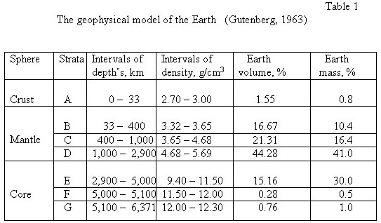 Many geochemical models of the chemical composition of internal spheres of the Earth were constructed, but to the present time only two were consolidated. Both propose the silicate-oxide composition of the crust and mantle, but differ in consistency of the core. In the first model the core is iron, and in the second - has the same silicate composition, as the mantle, but the oxygen joints at the center of the planet are consolidated and are metalized under the power of superhigh stresses. In silicates and oxides more than 90 % of the volume are occupied by anions of oxygen, the vacancy between which the cations Si, Mg, Fe, Al, Ca and other metals are involved. Therefore, both of the models postulate that oxygen is the most prevalent element in the composition of the planet Earth. According to V.N.Larin, the predominantly oxygen construction of the Earth is the major fundamental dogma in geology nowadays. What are the facts that support this idea? At first, the dense core and the presence of ferrous meteorites has been the predetermined thought about the accumulation of iron in the center of the planet, since iron alone has a high-gravity element widespread in the nature. Secondly, the Earth’s crust and the plutonic magmatic rocks have an oxygen-silicate composition. Thirdly, widely accepted view is that the meteorites reflect the composition of planets of the earthy type and on this presumption the «chondrite» model of the Earth is based (Marakushev, 1999). V.N.Larin (1980) made the comparison of the compositions of the Earth’s outer geosphere with the Sun’s composition, which revealed the existence of the interconnection between deficiency of any element and quantity of ionization potential of the first orbital electron. The deficiencies of elements sharply increase when ionization potential increases (Figure 1). That is to say, elemental concentrations in the Earth relative to their abundances in the Sun sharply decrease in parallel with rising ionization potentials. It should be noted, that in this case, as well as elsewhere in the context of our analysis, we are considering only the ionization potential of the first orbital electron. The meteorites as compared to the Earth are enriched with elements with high potentials of ionization (Au, Pt, Hg) and became poor by elements with low potentials of ionization (U, Rb, Cs, K). The matching compositions of basalts of the Earth and the Moon have not revealed any dependence in allocation of elements from their potential ionization that testifies to forming them from the same cosmos material. Thus, comparisons among chemical compositions of the Earth-Moon system, the Sun and the asteroid belt, as represented by meteorites, led to the discovery of a clear elemental order that is functionally related to the ionization potentials of the elements. This point needs specific emphasis. Elemental distributions depend exclusively on the ionization potentials, not upon other physical characteristics, such as atomic mass, atomic volume, melting temperature, volatilization temperature and so forth. This regularity’s evidence that during the process of elemental differentiation, matter was in ionized state, plasma, in the other words. A plasma state was possible only during the earliest period of the solar system. The coordination of element distribution with the ionization potential seems quite natural, because it is known that most of the present mass of the universe is in the plasma state. However, element separation within plasma is brought about by, and only possible in, a magnetic field. Scientific cosmology during the last two centuries has accumulated enough facts to invalidate most theories such as: 1) the accretion of protoplanetary matter around the Sun, and 2) the ejection of protoplanetary matter from the Sun by a cataclysmic event of some sort. The facts that confound these theories include the coincidence of the solar equator and the flatness of the ecliptic, the right-hand rotation of the planets, the small eccentricities of planetary orbits, the orientations and distribution of planetary momentum in the solar system, and other facts of cosmological science. The nebular concept, which comprises the idea of simultaneity in origin for the Sun and planets from a single nebular cloud, is supported by modern cosmo- logical facts. It maintains that the creation of the solar system commenced with a nebular cloud of dust and gas that made up the intra-stellar medium of our galaxy. Approximately 4.7 billion years ago, a supernova star exploded in the neighborhood of this nebula. As a result of this event, the nebula lost its gravitational stability and commenced to collapse. From its initial angular momentum, the nebular collapse moved to faster and faster rotation as collapse progressed. At the instant when centrifugal force equaled gravitational attraction, matter at equatorial latitudes started to flow outward. From this beginning the protoplanetary disk, oriented in the plane of the ecliptic, proceeded to form. Evolution from that point of instability turned the proto Sun into our star, its protoplanetary disk emerging with the full complement of planets. The theory of simultaneous origins of the planets and the Sun has prevailed generally for the last two centures (Kant & Laplace), notwithstanding that it fails to explain why 98% of the momentum of the system is concentrated in planets which have aggregate mass of less than 1/700 the mass of the Sun. Fred Hoyle developed a resolution of the enigma in 1958. He suggested that, during formation of the protoplanetary disk, a dipole magnetic field existed in which the magnetic flux lines were linked rapidly with partially ionized nebular matter, like “spokes of a wheel”. In this way the system could conserve rotational velocity at different distances from the axis of rotation. This model provides the appropriate mechanism for the transfer of momentum from the central regions of the collapsing nebula to peripheral regions (Hoyle, 1960). This aspect of Hoyle concept can be used to explain the origin of the previously recognized Cosmo chemical order. During protoplanetary disk formation, primordial matter, which had been “leaking” from the proto-Sun and spreading outward in the Sun’s equatorial plane, moved perpendicular to the lines of magnetic flux. Ionized particles, having only inherent thermal velocities, were unable to move through the flux and compelled to remain within the inner regions of the protoplanetary disk. At the same time, neutral particles were propelled outward, fractionated magnetically, that is to say, into peripheral regions of the disk. Particle conditions depended on ionization potential. If the ionization potential had been lower, there would have been more probability for an ionized particle to be captured by the magnetic field. Higher ionization potentials define higher likelihood for neutrality. The possibility for differentiation of ionized protoplanetary matter by the magnetic field has been suggested in earlier studies. Astrophysicist V.I.Moroz speculated that this process explains the differences between the inner and outer planets. The inner (“Earth-type”) planets are enriched in easily-ionized metals which could have been retained by the magnetic field of the proto-Sun; the outer (gas-giant planets), as their name implies, are made up mainly of gases, which have generally higher ionization potentials (Moroz, 1967). Deficiencies of inert gases also amenable to being explained as fractionation effects on these elements in the innerregions of the inner regions of the protoplanetary disk. At forming the protoplanetic disk the protosubstance, draining from the proto-Sun and spreading in plain of its equator, moved across magnetic power lines. The charged ions should be caught by a magnetic dipole and remain in the sun’s space. The neutral elements, on the contrary, should be extruded and left in exterior zones of the disk on its peripherals. Thus, there was a magnetic separation of charged ions on their potentials of ionization, in light of which the cosmochemical regularities of allocation elements in planets of the Solar System get simple and natural argument (Larin,1980). The nature of the location of metals with potentials of ionization lower than 8 ev on the diagram (Figura 1) demonstrates, that all elements are lower than the potential of ionization Si = 8,15 ev should be completely ionized. According to dependence Е = 3/2 kТ, where Е - ionization energy peer 7-8 еv, k- the Boltzmann constant, to this energy situation corresponds temperature Т of the order 60000 Сo, at which there was the complete dissociation of chemical combinations on elements and ions. Therefore, the Earth should have inherited the solar spectrum of elements with potentials of ionization up to 8 еv. It follows, that the relative abundances of metals on Earth must correspond to their relative abundances in the Sun. The conclusion that follows from the foregoing is that, among terrestrial metals, Si, Mg and to a lesser extent, Fe, should reflect a distribution representative of the Sun. These elements must dominate others on Earth. Al, Ca and Na should have less significant roles; the remaining metals represent but small to vanishing percentages of total Earth mass. S, C and N are all widespread on the Sun, where they occur in order next only to H and He. However, their elevated ionization potentials along with correspondingly higher deficiency coefficients imply relative concentrations on Earth that are less than anticipated values by two to three orders of magnitude. Oxygen is less in three orders than on the Sun. According to high potential of ionization of oxygen (13,6 еv), it should leave the zone of planets of earth grouped in the zone of forming of planets-giants, as it is supervised actually (Table 2). The general balance of element’s concentrations on the primordial Earth founded by the phenomena of the magnetic separation (Table 2), testifies against major geological dogma to dominance of oxygen in the composition of our planet. It is possible to assume, that the initial abundance of oxygen on the Earth was small, but during its development it was reallocated and concentrated in exterior geospheres. 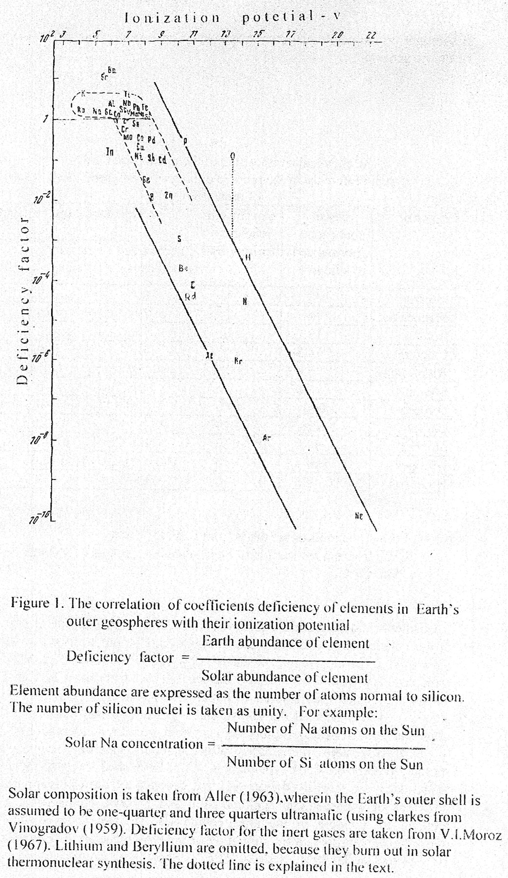 It must be remembered that the proto-matter, which “flowed” from the proto-Sun was dominantly hydrogen. If the hydrogen deficiency coefficient (relative to an ionization potential of 13.6 V) is taken as 10-3 – 10-4, the initial hydrogen concentration in the orbital zone of the Earth must have been high enough to allow all elements to exist as hydridic compounds with a stoichiometric form of EH – EH2 (Table 2). Thus, there is no problem for the retention of hydrogen throughout the process of proto-matter condensation, because metals, as explained below, have a strong affinity for hydrogen. There is, for example, a report on the condensation of iron vapor in an atmosphere of hydrogen in which metallic atom “attracted” a matching hydrogen molecule (Galaktionova, 1967). Hence, there is a significant likelihood that the primordial composition of the Earth was permeated with hydrides. At the same time, the percentages by weight of hydrogen in the whole planetary mass would have been about 4.5%, but reached 59 atomic percents. 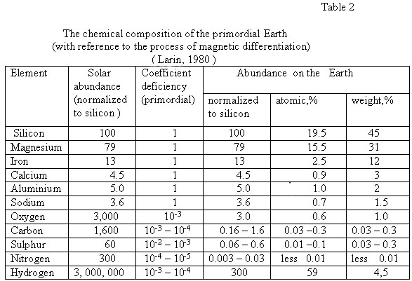 Notes: 1.Solar abundances are taken from L.Aller (1963); 2.The frequent association of Fe is taken into account of abundance Mn, Cr, Co. Cosmochemical regularities are an evidence for the plasma state of proto-matter in the nebular stage of solar system formation. The pinch effect, acting on the plasma at a certain point, precisely allowed generation of globules in the protoplanetary disk. The research carried out by T.N.Eneev and N.N.Kozlov (1977) shows that gravitational evolution of such a model can only produce a planetary system with all the known characteristics (planet numbers, orbits and rotational characteristics), if planetary accretion precedes condensation. In this scenario, immediately after accretion, extended gaseous globules should represent the Earth-type planets. With diminished levels of radiation (due to the decay of short-lived isotopes) and decrease of the Coulomb barrier, the processes of condensation, agglomeration and collapse commenced. The time required for collapse of the proto-nebula was the time between the loss of gravitational stability and the formation of the protoplanetary disk is estimated as 106 years (Kuroda, 1961; Reeves, 1976 ). Short-lived isotopes produced in this process are most likely to be 10 Be, 26Al, 53Mn, 60Fe, and others with half-lives that approximate 106 years. Within a gravitationally controlled globule of protoplanetary matter, the growth of larger bodies was impossible. The condensation process of planetary matter followed by its collapse into solid bodies is, exactly best thought, as a “snow fall” directed toward the mass center of the proto-planet, rather than the popular concept of our day, an energetic bombardment of embryonic planets by asteroid-sized, solid bodies. Thus, it is possible to consider, that the accretion of the planet Earth has taken place earlier than the condensation of protoplanet matter began, i.e. the accretion (growth from center to peripherals) preceded condensation. The comparison of compositions of the Sun and Earth allows affirming that in the matter, from which our planet was derivate, the relative distribution of elements has not transformed that was conditioned by the magnetic separation. If to assume that the condensation preceded the accretion, in this case it is not obviously possible to save without losses the matter issued from magnetic separator on all the stage of its accretion in the body of planet, so far as the no condensed phase had a lot of possibilities to be dispelled, for example, the inert gases. Detected by V.N.Larin (1980) cosmochemical tendencies open the new outlooks in the field of the planet chemistry. These tendencies also allow essentially confining optional versions of physical-mechanical compositions, which are aroused at the formation of the Solar system and the planet Earth. In order to understand the evolution of the primordial hydridic Earth and to determine the cause of planet’s present unique characteristics, it is necessary to review some aspects of hydrogen-metal interactivities in various environments. Almost all metals can react with hydrogen. Metal interactivity proceeds first with adsorption of hydrogen on the metal surface, then as occlusions within the metal, and thence to chemical reaction and creation of hydrides. Adsorption and occlusion are purely physical processes. With adsorption, a dissociation of hydrogen molecules into separate atomic nuclei occurs. With occlusion, the atomic nuclei give up their electrons, and the nuclei assume existences within the metal lattice in the manner of a proton gas. A single metal volume is able to occlude hundreds – even thousands of hydrogen volumes. That the metal lattice is preserved, albeit with slightly altered characteristics, is evidence that no chemical reaction has occurred. The third form of interactivity, chemical reaction between metals and hydrogen produces the whole range of chemical compounds known as the hydrides. These compounds have new lattice forms in which hydrogen is chemically bonded to metals and is represented as hydride ion, “H-“, a proton and two electrons. The existence of hydrogen in ionic form, a hydride ion, as well as in the free proton stage through occlusion, are proved today through extensive research (Galactionova, 1967; Mackay, 1968). A proposition made by Gibbs (1962), holds that the hydrogen proton in a metal lattice is an active form of the hydride ion. It is important to emphasize, that the high pressure considerably increases temperature stability of the hydrides. In fact, it may be said, that for dissociation to proceed under conditions of increased pressure, there is a requirement for higher temperature (Mackay, 1968). Therefore, hydrogen-saturated native metals under high and super-high pressures exist only in the hydridic state. As increasing temperature causes the dissociation of hydrides, the hydrogen ions pass into the proton gas state while still dispersed in their metal hosts. Finally, increasing temperature expels them from the metals. Purification of metal by purging, the flushing of hydrogen through it, has been used in steel industry for many years. Hydrogen flushing is known as an effective method for removal of oxygen, nitrogen and carbon from iron, chrome and others metals (Hopkins et al, 1951; Galactionova, 1967). Keeping this in mind, it is possible to outline the evolutionary course to be expected for the internal structure of a primordially hydridic Earth. The basis for the following evolutionary sequences determined by the traditional idea of initial radioactive heating. Gravitational differentiating and the phase transferring of matter in under crust depths at the early stages of development of the planet, apparently, produced, noticeable contribution to its energetic, but they had a damping nature. However, periodically replicated plutonic tectono-magmatic processes of activation should be linked, in main, with evolution of the Solar system and our Galaxy. One of the possible ways of transmission the galactic energy in the body of the Earth is passing the Solar system through galactic radiation belts (Kulinkovich, 1992). At intersection the galactic radioactivity, or magnetic belts the variable component of ionospheres currents sharply increases, which induces in the Earth’s core Fuko currents (Poletavkin, 1981). Apparently, it is accompanied by considerable emission of thermal energy involving partial melting of the Earth’s core, variance of volume of the planet, and as the result, activation of the tectono-magmatic processes. While warming up, the hydridic Earth should have differentiated into some geospherical layers, due to the fact that its interior hydrides became unstable. Hydrides situated at the planetary center, where pressure is maximal, would have been preserved from dissociation for relatively long time. Rather, the hydrides must have been encased in geospheres of metals saturated with occluded hydrogen. The saturated metals, in their turn, must have been encased within higher geospheres from which the hydrogen had been expelled. Such was the evolutionary process that originated the hydrogen-bearing interiors of our planet with central hydridic core and metallic mantle. It is easy to recognize that the thickness of the mantle during geological history has expanded while the core has shrunk. The metallic mantle, flushed with hydrogen from the interior, would have been scrubbed and freed of oxygen admixtures in the manner of laboratory techniques. Escaping oxygen, in its turn, must have become infused into the minerals of the outer geospheres before it could escape into the atmosphere. That explains the outwardly increasing silicate and oxide-rich composition of the outer solid geospheres. Evidently, the origin of extreme heat flows cannot be resolved without the invention of efficient heat-transfer agents. The best candidate for this role is hydrogen due to its heat capacity and migrations capabilities. The phenomenon is the high specific heat characteristic of hydrogen. For molecular H2 at 25oC this is 14,4 J/goK; for atomic H it is 21 J/goK, both orders of magnitude greater than other elemental specific heats. There are numerous data today that prove the predominance of hydrogen in fluids of the upper mantle (Marakushev & Perchuk 1972,1973; Lutz 1975; Letnikov 1976, 1977). These fluids are oxidized into water in the crust, although not always ever there, at least not completely (Betelev 1965; Vasil’ev et al. 1968). Even given the lowest estimates of hydrogen diffusion rates in metals, the time needed for it to travel from the core to the outer geospheres, through the metallic mantle, should not exceed 104 years. Had the entire mantle been composed of silicates and oxide minerals, the hydrogen would have been locked inside the planet, because its diffusion rate in silicates is several orders of magnitude below that in metals. Based on the forgoing reasons, V.N.Larin (1980) suggests a new geochemical model of the Earth, which is consistent with the latest geophysical data, but completely different from the current geochemical models. The main differences between this model and traditional models, is in the limitation of the silicate- and oxide-rich geosphere to depth ranges of no more than 350-400 km under the continents and even less under the oceans. In Larin’s opinion, the major portion of the Earth’s volume is non-oxides and mainly silicon and magnesium metal, but also incorporates iron and coactive calcium, aluminum, sodium, and other elements in lesser quantities. All these elements in the outer core contain dissolved hydrogen, whereas in the inner core they are present as metal hydrides (Table 3). V.N.Larin in his experiments has found out the new phenomenon: at high pressure the metals with dissolved hydrogen become liquids. This phenomenon is observed at room temperature. Thus, the outer core of the Earth must be liquid (metals with dissolved hydrogen), while at the same time “cold”. It shows that the conception of the periodically cold core does not present as a paradox (Larin, 1993). The main geologic-tectonic consequence of the concept of primordial hydridic Earth is considerable, probably, multiple increase of its volume during the geological history, that was determined by almost continuous decompression. bowels of the planet at the degassing of hydrogen and transferring hydrides in metals. The idea of the expanding Earth for the first time was expressed in 1859 by English military surveyor A.U.Drayson in the book « The Earth, the one on which we live: its past, present and future », where on the basis of set of surveying measuring, he had come to the conclusion, that the Earth is expanding with major speed. Then, independent from each other, I.O.Yarkovskiy (1899), Mantovany (1909), Khickson(1920), M.Bogolepov (1922), B.Lindemann (1927), О. Gilgenberg (1933), P. Dirac (1937), E.E.Milanovsky (1978), W.Carey (1988) and some other authors have published their observations about the expanding Earth. 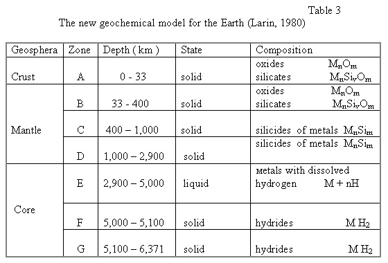 In the second half of our century the new data appeared on the structure of the bottom of the oceans, its sediments and rocks, the nature of the magnetic fields, legitimacy position of mid-oceanic ridges and global rift system, brought about a revolution in global geological ideas. By the beginning of the 1980’s, theoretical research was essentially extended in the field of geodynamics within which further evolution of the ideas and conceptions of fixism (V.V.Belousov, M.V.Muratov), мobilism (A.V.Peyve, E.V.Artyushkov, L.P.Zonenshain), as well as contracting and expanding the Earth (S.W. Carey, V.B.Neyman, V.N.Larin, E.E.Milanovsky and others) were accepted. Geological-tectonic and the geophysical features of the structure of the oceanic bottom allows us to consider them as the structures of gigantic extension. These could possibly be connected with general expansion of the planet Earth. The continents and their structures stand at the same places and are rigidly connected by their plutonic roots in the mantle, but, in accordance with the expansion of the planet, they diverge and between them oceanic depressions appear and grow. In the opinion of V.E.Khain (1970) a hypothesis of the expanding Earth could resolve the tighten discussion between fixism and mobilism, since it allows to fasten the persistence of the structural plan (the main credo of fixists) with pulling apart the continental plates and neoplasms of oceans (in which the mobilists are right). 2. CLASSIFICATION OF THE GEODYNAMIC SYSTEMS For segregation the geodynamic systems and their components the following parameters were used: a) the composition and structure of geological bodies, b) the age and evolution of litospheral stratums, blocks and segments, c) the energetic and other features of the thermodynamic state of the earth’s crust and upper mantle in modern or past geological epochs, d) the direction and, whenever possible, intensity of acting regional and global forces, resulting to vertical and horizontal movements of geological bodies (Smyslov,1983). The Geodynamic systems, that shown as a basis of the present Metallogenic map, have been subdivided on different age, scale, thermodynamic regime of degassing the protonic hydrogen out of the core, geodynamic and tectonic movements and types of the earth’s crust. The geodynamic systems are the self-regulating geological structures, where the processes of substantial differentiation, energetic and structural rebuilding have been arisen by cooperation of global ( core-mantle ) and regional ( crust ) forces of the Earth (Table 4). The hierarchy and classification of geodynamic subdivisions should be allow, alongside with usual parameters: (sizes, morphology, composition), the interconnection of the energetically sources and active forces, moving to directional and unalterable development of the Earth. In view of this position, the geodynamic zoning of lithosphere of the Earth was conducted, for which geodynamic system is accepted as the major one unit for measurement. In the hierarchy it holds the central place and corresponds in its scale to such morphotectonic units as continents and oceans, with a subdivision into global, regional and local types. As for morphology, the division make into polygonal and linear types (Table 5). The following polygonal geodynamic systems are being selected (based on the features of vertical movements): 1. with dominating elevation – the Precambrian cratons, shields, granite-gneisis domes, median massives; 2. with intensive elevation after considerable depression (till 5-10 km) – the polygon-geosynclinal-folded areas of Phanerozoic; 3.with directional and long-lived depression - the deep uncompensated whipping with maximum (10-20 km) for earth’s crust depression and power sediments. 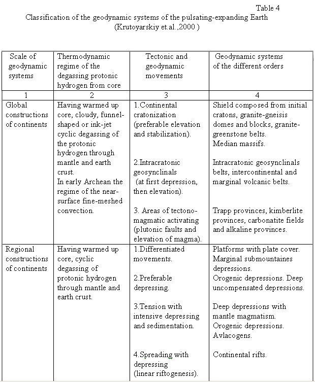 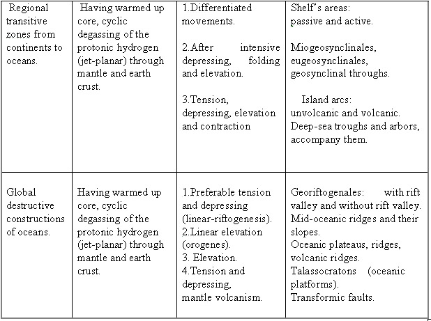 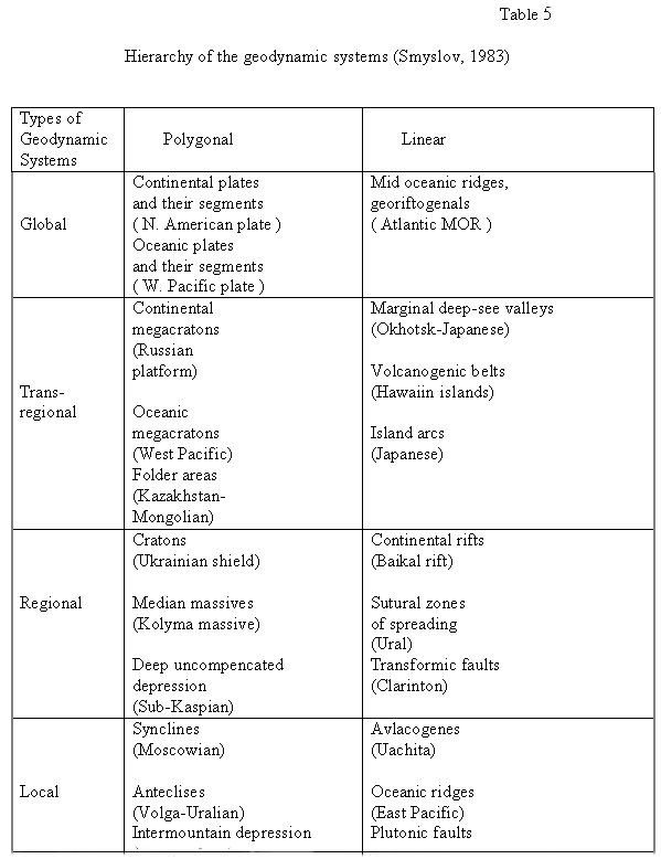 The geodynamic systems of the Earth, concerning their thermodynamic regimes, were subdivided in three types: have been stabilized ( had cooled), are still stabilizing (are cooling) and active (warming up). Three following types of lithosphere have been distinguished that appear in various stages of the development of the Earth, and which are typical for different geodynamic systems with consideration of duration and evolution of the substance and energy of the mantle-crust blocks on the continents and oceans: 1. ancient (Archean-Proterozoic) consolidated lithosphere and sharp differentiated continental earth’s crust of salic type with thickness 35-60 km; 2. ripen (Riphean-Paleozoic ) consolidated lithosphere with differentiated earth’s crust of salic-femic type with powerful about 20-35 km; 3. young (Mesozoic – Cenozoic) generating lithosphere of oceanic femic type, that began forming in Mesozoic and continued up to the present time along the georiftogenal, with earth’s femic crust of thickness near 6-10 km. The Sub-Caspian uncompensated depression is the example that before regards to the cover of Russian platform. Such type of depression is probably antipodes of median massives that have advantage to elevation. Peculiar feature of all types of polygon systems is the dominance of the crust material differentiation at the mantle energetic and dynamic supply, determining long-lived stable and directional elevation of structures or their depression. Essentially another processes and activing forces are peculiar for linear geodynamic systems, distinguished in independent groups, for which are characteristically extension (rifts, pull-aparts), more seldom compression (pulls) or combined moves (compression – extension), conventional by horizontal movements of geological bodies. However, in these structures at the dominant role of vertical moves of matter in the next stages are fixed vertical movements. For example, the downing in central parts of zones pull-apart (rifts) is combined with powerful accumulation of sediments and / or intrusion of mantle magmatic matter ( Smyslov, 1998 ). The linear geodynamic systems are usually disposed at the center or on the periphery of polygon mosaic structure, forming sutured zones of different scale. For example, the global spreading georiftgenalic zones are found in the center of oceanic depressions with the identical type of lithosphere. The transregional Benioff zones, the island arcs and the volcanic belts are disposed on boundaries of mantle-crust blocks. The regional and local continental rifts, plutonic faults, avlakogenes are usually located at the periphery of polygon geodynamic systems. The sutured zones of pulling apart are widely developed among the linear systems, along which the intrusions of mantle matter, such as hyperbasits, basic vulcanites, protrusions of ophiolites are impregnated. In some cases the rift’s depressions take place the powerful sedimentation and with the subsequent folding and forming of riftogenal-folded zones. As a whole, the linear geodynamic systems have a major vertical extension, and they swish the Earth’s crust on all its power and go away with their roots to considerable depth (100-200 km) in the upper mantle. Such systems on the features of differentiating of the matter and the nature of energetic and geodynamic supply can be regarded as mantle-crust. Between the extreme types of geodynamic systems (polygon and linear) there are systems with expressed linearity can be selected, the formation and evolution of which is conditioned by combination of horizontal and vertical displacements of the earth’s crust. Among them there are exponents of crust systems (edge troughs, salic volcanogenic belts, miogeosynclinals), mantle-crust (eugeosynclinals) and mantle (belts of mantle rocks) systems. The polygonal and linear geodynamic systems of material composition of geologic bodies are sectioned into salic, salic-femic and femic. On the Earth, as it was clarified in the last decades of our century, the unique polygon geodynamic systems are represented by plate structures of depression and subsequent elevation, are widely developed. Intensive disconsolidation of matter crust-uppermantle stratum and global manifestation of basic magmatism are peculiar for them.. On the continents they are introduced rather infrequently, but vast on the areas trapp’s provinces like as Tunguss syneclise, Кarru, Hindustan etc. On the contrary, in all ocean depressions the immersed oceanic plates with powerful basalt’s cover are widely spread. It is necessary to note, that during the tectonic-magmatic evolution the stage of submergence and stabilizing of oceanic platforms, which are accompany by areal type of basic magmatism, is replaced by the later stage of rifting formation with particular comatiit-tholeite and tholeite basalt volcanism (Staritsina et al., 1986). Besides the above mentioned global and regional geodynamic systems, there are local geodynamic systems, introduced by the structure of explosive or impact genesis, for example, kimberlite or basalt explosion pipes, cryptovolcans, meteoritic craters and astroblems. 3. LEGENDS TO THE METALLOGENY MAP The present Metallogenic map of the geodynamic systems of the pulsating-expanding Earth (scale 1:15,000,000) is compiled on the basis of the following published maps: 1. Geologic map of the World (1970) (scale 1:15,000,000); 2. Geodynamic map of the World (1987) (scale 1:45,000,000); 3. Map of mineral resources of continents of the World (1970) ( scale 1:15,000,000); 4. Map of solid mineral resources of the World Ocean (1991) (scale 1:25,000,000). In addition, some other published maps and materials have been utilized, which are mentioned in the subtitle of the map. The legend of the present Metallogenic map is subdivided into two parts: I. Segregation of the geodynamic systems and areas; II. Mineral deposits, typical for each of the geodynamic system and age. Part I of the legend holds the geodynamic systems (GDS) of different age that have been shown on the map. They are subdivided by the scale, thermodynamic regime of degassing protonic hydrogen out of the core, geodynamic and tectonic movements and types of the Earth’s crust (table 4). The geodynamic systems for the oceanic and continental segments of the lithosphere are shown on the Memallogenic map. They are the self-regulating geological structures, where the processes of substantial differentiation, energetic and structural rebuilding have arisen by cooperation of global ( core-mantle ) and regional ( crust ) forces of the Earth. Part II of the legend show the symbols of mineral deposits connected with different geodynamic systems. The deposits are subdivided according to mineral reserves into unique, large, middle and fine. On the map they are numbered by ten-degree geodesic trapeziums and have indexes of useful elements. The symbols of small deposits without numbers represent a large ore displays or deposits with unknown reserves. On the separate applications to the map, there are the lists of the titles of deposits; their index and numbers on the map are reduced. The state’s accessory (in alphabetic order or by ten-degree trapezoids) is indicated on the special applications to the map. There are the following genetic types of the deposits: magmatic, post-magmatic, weathering, sedimentary, placer, metamorphogenic, and also oil and fuel gas. The post-magmatic deposits are subdivided into the hydrothermal, skarn, greisen, albitite, sulphural, telethermal and carbonatite subtypes. The mineral resources are sectioned into deposits of metals, nonmetals and combustible minerals. Among metallic mineral resources the deposits of black metals (Fe, Mn, Ti, Cr), colored metals (Pb, Zn, Cu, Sn, Al), alloying metals (W, Ni, Co, Mo, V), infrequent metals (Nb, Ta, Li, Be, TR, Zr), noble metals (Au, Ag, Pt, Pd, Os), radioactive metals (U, Th, Ra) and small metals (Hg, Bi, As, Sb) are selected. Chemical raw, other nonmetals and jewel stone represent the nonmetallic mineral resources. Among chemical raw there are selected: the phosphates ore, apatite, various salts, pyrite, fluorite and barite. From other nonmetals there are asbestos, magnesite, graphite, icelandic spar, muscovite, phlogopite, vermiculite, kyanite and emery are subdivided. The jewel stones are represented by diamond, emerald, beryl, aquamarine, ruby, sapphire, topaz, turquoise, lazurite and opal. Stone and brown coal, fuel shale, oil and fuel gas adduce the combustible minerals. Among the detected mineral resources at the bottom of seas and oceans the following ore formations are selected: magmatic (Cr, Pt, Ni, Co), hydrothermal sulfide (Cu, Zn, Pb), hydrothermal – sedimentary polymetal-sulfide (Fe, Mn, Cu, Zn, Pb), oxidant-iron metalloferous sediments (Fe, Mn), sedimentary iron-manganese concretions and crusts (Fe, Mn, Cu, Ni, Co), phosphorites (Р), sea-shore and littoral placers of diamond, gold, platinum, cassiterite, monazite, titanic minerals and zircon. In addition on the passive shelfs, the giant deposits of oil and combustion gas are opened. Along the continental slope considerable accumulations of gas-gidrates (solid phase of water and methane) are detected. The metallogenic zoning on survey maps of such small scale it is possible conducting only at the level of the metallogenic provinces. The separation the structural metallogenic belts, zones, ore districts and knots is practically impossible; it would be overstrain the map. Whereas the fact, that every separate geodynamic system with their mineral deposits indicated one age metallogenic province, on the present map had not provided more detailed metallogenic zoning. 4. METALLOGENY OF GEODYNAMIC CYCLES, STAGES AND SYSTEMS We selected the following geodynamic cycles based on systematic analysis of the geological development of the primordial hydride Earth from protoplanetary up to the modern time: I . protoplanetary (4,600-3,600 Ma); II. permobilic (3,600-2,000 Ma); III. protocontinental and protooceanic (2,000-900 Ma); IV. platform-geosynclinal and oceanic (900-200 Ma); V. continental - oceanic (200 – 0 Ma). The other factors that were considered are: the harmonically analysis of oscillation of the earth’s crust (Grozdilov, 1974); the periodicity of the epochs of kimberlite magmatism on radiological dates as compared to the sidereal calendar about 215-225 Ma (Milashev,1994). Each of the geodynamic cycles is subdivided into three stages: early, middle and late. The exception from this subdivision is the protoplanetary cycle, in which only the middle and late stages have been selected. The early stage, apparently, falls into the accretion and the condensation stages of forming the planet from the gas-dust nebula (Figure 2). I. P r o t o p l a n e t a r y c y c l e (4,600-3,600 Ma) of development of the Earth had begun immediately after the collapse of the planet, when the gravity was approximately 3 times more, and the radius at 2.5 times less than the modern ones (Larin, 1980). The protoplanetary cycle is subdivided in two stages – l u n a r and n u c l e a r. I. 1. L u n a r s t a g e (4,600-4,200 Ma) was selected by analogy with the most ancient mafic rocks on the Moon, the age of which is dated by radiological dimension in 4,600-4,300 Ma. The oldest members of the world’s largest anorthosite massifs have mafic compositions and exhibit circular structural forms. These features are now recognized as characteristic of the earliest era in Earth history – a unique “lunar” stage in Katarchean (Glukhovskiy & Pavlovskiy, 1973). Most probably, at this time the Earth protocontinental crust had been of a gabbro-norite-anorthosite composition, pitted on the surface by basalt volcanic craters and calderas. It is possible to explain the formation of lunar craters on the Moon and the Earth in Katarchean not only by external actions (bombardment of the surface by asteroids and meteorites), but also by internal conditions of the development of these related planets. So, from the position of primordial hydridic Earth, at radioactive warming up, the hydridic core began to emphasize scattered gas jets of protonal hydrogen, above which in the upper mantle the areas of compressing and downing of silicides metals were arisen. The reaction of some more thin and plastic silicate crust above such areas of downing was formation depression craters and on the surface of the Earth orbed depressions, where the basalt magma was effused. Thus, than less the deep of location the focal point of a blast of the volcano, then wider on the surface was the diameter of a “lunar” crater, and vice versa. 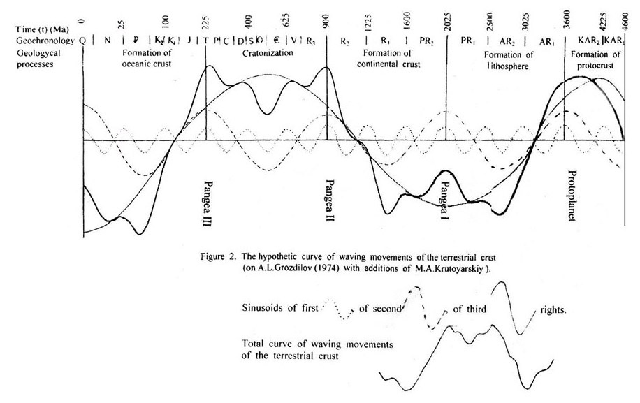 The most believable skyscape on the surface of the Earth in early Katarchean are vast orbed-oval deep depressions filled with basalt’s lavas (« the lunar seas»), which are disparted by low «continental plateaus », composed by massifs of anorthosites, gabbro-norites, gabbro-dolerites and products of their differentiation. The terrain surface at that time was warm up to several hundred of grades Celsius and was enwrapped in a dense carbonic atmosphere still completely dispossessed of oxygen, such as on modern planet Venus. The basic rocks of the lunar stage were subsequently overlapped by younger geological formations and immersed in the depth of earth crust, where as a result of regional metamorphism they were turned into eclogites, composing the upper horizons of mantle together with unltrabasic rocks. The type of magma at the «lunar» stage of development of the Earth is instituted as primitively basic (tholeiite-basalts, gabbro and аnorthosites) with clearly expressed homjdromic evolution. The low activity of oxygen in tholeiitic magma explains the restorer forms of metals in trapps and presence the native nuggets crystals of iron, aluminum and copper in them (Oleynikov et al., 1978). There are finds of native nuggets of iron in Siberian trapps and on the island of Disco. The tellure’s iron nuggets weighing up to several tons are met in Greenland (Betechtin, 1950). Аrchean and Proterozoic аnorthosites are specialized in iron, titanium, aluminum and phosphorus. On this basis, it is possible to guess, that Katarchean metallogenic epoch of the «lunar» stage of development of the Earth, was specialized on initial concentration for the siderophile (titanium, iron), as well as on the lithophile (phosphorus, aluminum) elements, reflecting the conditions of forming the primitive basalt crust. I. 2. N u c l e a r s t a g e (4,200-3,б00 Ma). In late Katarchean there was the formation of protocontinental «greygneissic» crust, which consisted completely of metamorphic magmatic rocks, represented by andesites, dacites, tonalites, trondhjemites and plagiogranites, coincident on midlle chemical composition to diorite with sharp dominance of sodium over potassium. In a lesser degree, the horizons of metamorphic sedimentary- volcanic rocks are found. The greygneissic complexes of rocks with absolute age 3,900-3,200 Ma. are found on all continents of the Earth. The separate dome-shaped elevations of these rocks vary in diameter from several hundreds up to thousand kilometers. In the late Katarchean there were «islands» of salic crusts folded by the greygneissic complexes of rocks rather multiplied composition, which have received the title «nuclear» (Pavlovskiy & Gluchovskoy, 1982). It is quite possible, that the large dome-shaped structure of ancient shields, observed on space snapshots, can be the relics of salic islands of Katarchean. Among them the dome Ungava (Canadian shield), Aldano-Timpton dome (Aldan shield), Singbum dome (Indian shield) and dome Pilbara (West-Australian shield) can be regard (Khain, Bozhko, 1988). In late Katarchean there were already aqueous basins, with depositions of sedimentary rocks and pillow-lava of the serial Isua in Greenland. However, water pools at that time were, apparently, small and flat, somewhat sunk in depression between dome-shaped elevations. The water was free of dissolved sulfates and oxygen, but contained chlorides. The lower hydrogen ions concentration in comparison with modern (рН = 7.0 instead of 7.5-8.5) precluded depositing carbonates from the water. The temperature of the water was above modern. The atmosphere was strongly different from modern and resembled venerian. The rotation rate of the Earth was considerably higher; the duration of day in Katarchean consisted of 5 hours. The major closeness of the Moon to the Earth caused power lunar affluxes. The solar radiating was more intensive (Monin, 1983). The geodynamic regime of the nuclear stage of development of the Earth differed by high geothermal gradients (54o C/km), waterless granulate metamorphism and fine-meshed near-surface convection in the upper mantle and crust. According to many researchers, the striking reaction of asteroids and meteorites on the surface of the Earth in the period between 4200-3800 M.a. determined the localization upraised of mantle jets and growth of sialic nuclear above them. In intermediate depressions between rising domes, there were, probably, downward convective currents and the accumulation of the sedimentary - volcanogenic depositions in the initial water basins (Khain, Bozhko, 1988). From the position of primordial hydridic Earth, as a result of radioactive warming up exterior layer of the core, the separation of disorderly streams of protonic hydrogen and the hydrogen blow-down of bowels of the Earth to the end of Katarchean and in the beginning of Archean there was the enrichment by oxygen the rocks of the upper mantle and earth crust with formation of silicate-oxide lithosphere. The earth’s crust at the depth of 25-30 km appeared composed above by «greygneissic» dioritic complex of rocks, and below by primitive basaltoic rocks. Metallogeny of the nuclear stage is less known. It is found, that the Katarchean «greygneissic” complex is enriched a little by Ni, Cr, Fe, V, but has low contents of lithophile elements, including U, Th, Rb, Ti, Zr, F, Nb, Ba, Sr, B, in comparison with normal granites (Khain, Bozhko, 1988). In the composition of « greygneissic » complex of rocks the layers of ferriferous quartzites, jaspilites, aluminous quartzites, gneisses and shales are being found. The most ancient deposit of ferriferous quartzites is found in a southwest part of Greenland in district Godhab-fiord in the complex Isua. The absolute age of these quartzites equals 3,760 Ma., and the reserves of iron ores compound here 2100 Mt. The ferriferous quartzites were generated, apparently, at the expense of redeposition of products of the chemical weathering basic rocks in adjacent fine aqueous basins. In the Western Greenland, large scheelites deposits dated to metavolcanic acidic and basic composition with intercalation of carbonate rocks and metapelites complex Isua (3,800 Ma) are detected, as well as in younger supercrustal complex Maline (3,000-2,800 Ma.). Scheelite is dated to аmphibolites with initial pillow-lava and tightly associates with the tourmaline (Andreev et al., 1997). The analysis of available materials allows making a preliminary conclusion, that the Katarchean metallogenic epoch was specialized on initial concentration of siderophile (iron, titanium) and, to a lesser degree, to lithophile (aluminum, tungsten, phosphorum) elements. At the expense of the chemical weathering of basalts, gabbro and anorthosites, the redepositions of products of the airing in superficial aqueous basins and subsequent processes of regional metamorphism were generated deposits of the indicated mineral resources. II. P e r m o b i l e c y c l e (3,600 – 2,000 Ma) of geological development of the Earth is subdivided into three stages: 1. early Archean (3,600- 3,000 Ma ); 2. late Archean (3,000 – 2,500 Ma) and 3. early Proterozoic (2,500 – 2,000 Ma). The geodynamic conditions and nature of geological processes in Archean are specified by particular features, when the surface of the planet was still strongly heated, the hydrosphere is practically absent, and the half-plastic lithosphere was in stage of forming, that does not allow to make conclusions on the principles of actualism. At this time complexes of rocks, unique in composition, were constituted, which are not present any more, or extremely rare among the later formations. The presence of comatiites, enderbites, charnockites, аnorthosites, granulites, jaspilites, testify to the higher thermodynamic level of magmatism, metamorphism and deformation of rocks. The regarded cycle of development of the earth crust is called by L.I.Salop (1982) as p e r m o b i l e , which one differed by overall tectonic mobility of the structures. The latter were represented by cratons, composed from granulite-gneisis, granite - gneisis, granulite-greenstone and granite – greenstone areas, with infrequent and small epicratonic sedimentary aqueous basins and intracratonic geosynclines. In the early Archean, oxygen-silicate lithosphere of the Earth was still strongly heated, the geothermal gradient compounded 54 o C / km, and the heat stream in 2-3 times exceeded modern (Crambling, 1981). The early Archean lithosphere, more probably, had elastic-tenacious consistency and was rather plastic. The degassing of protonic hydrogen from hydridic core of the Earth in accordance with raising thickness of the mantle and crust has become to turn from universal surfaces to lateral-jet. At the location of the thermal hydrogen stream in intermetallic midlle mantle (zone С) and saturation of protonic hydrogen the heat-conducting zone (tectonogen), the metals, composing it should be undergoing compression. As a consequence, in mouth part of the heat stream at intrusion it in silicate sphere of the upper mantle (zone В) will be reshaped a zone of downing, on which silicate mantle will be immersed in metallic (Larin, 1980). The reaction of the astenosphere to such downing will be the formation a lengthwise depression. The consequence of these processes on the surface of the Earth, will be appearance a protogeosinclinal baths and sedimentary – volcanic infill them. Alongside with it, if the location of such depressions originated in linking to a rifting zone, it acquired features «eugeosyncline» with early primitive basalt and comatiitic volcanism, which once was ended by the intrusion of granitoids sodium of rank. The foundation of such volcanic-plutonic greenstones belts, as a rule, is represented by introduction of more ancient «greygneissic» complex or granulites of Katarchean or Archean age. The Аrchean granite – greenstone belts are detected on all continents, occupying not less than two-third of the areas of the shields. The rest areas of protocratons are represented by granulite-gneisis formations of Archean age (Khain, Bozhko, 1988). In the Archean the lithosphere became more stable as evidenced by the appearence of large intrusive massifs, among them 3,500 – 3,300 Ma old granitoides (Pavlovskiy,1975). Their emplacement marked the first sign of an emerging granite crustal layer. Where the granitoids, characteristically with low-K and primary enderbite, were sporadic; and the crust remained largely mafic, later in the Archean, metamorphism became more diverse so that, along with granulites, scattered sediments were deposited. Nevertheless, these now-metamorphosed rocks still do not exceed the greenschist facies in volume. Everywhere, the feature left from the geodynamic regime of that era is persistently irregular in orientation and form. The close of Archean was marked by perturbation of the existing tectonic regime on a massive scale. An intense pulse of potassium granitization pervasively affected Archean mafic basement. The granite layer of earth’s crust was initiated and commenced to evolve and expand at this time. Typically Archean, anhydrous granulites gave way everywhere to the hydrous metamorphism of greenschist and amphibolites facies. Commencing in early Proterozoic time, geothermal gradients decreased rapidly, lithosphere stability increased, and sedimentation acquired a protoplatform character. However, sedimentation under these conditions, in contrast to that of the platforms of the Neogaicum, was accompanied by high-grade metamorphism (up to amphibolites grade) and intense granitization of the Archean mafic basement and its protoplatformal cover. The altered cover was then subject to folding on the peripheries of its growing granite-gneiss domes (Pavlovskiy, 1975). The fundamental manifestation of perturbation of the tectonic regime at the Archean-Proterozoic boundary was the emergence of extended linear feature, which expressed the existence of horizontally directed fields of stress and deformation (Pavlovskiy & Markov, 1963). These formations have been accepted into the literature as “greenstone belts”, which was differing from Phanerozoic geosynclinal fold belts (Markov, 1962). They were being smaller in area, relatively simple in internal structure (without observed differentiation into geanticlinal or intra-geosynclinal zones), absence of foredeeps, and a reduced tendency toward orogenesis (absence of typical molasse). Researches tend to view them as prototypes for later geosynclines of Neogaicum. Simultaneously with the evolution of greenstone belts, intense granitization of the crust continued through the early- and the part of the middle Proterozoic. As a result, about 80 % of the area of the present continental crust dates back to this span of time, making this period the main stage of granitization and granite formation in all of Earth’s history. II.1. E a r l y A r c h e a n s t a g e (3,600-3,000 Ma) of permobile cycle of geological development of the Earth represent by the protocontinental cratons, that are composed from granulite-gneisis, granite - gneisis, granulite-greenstone and granite–greenstone areas and belts. On the modern continents, they constitute deep eroded uplifted Precambrian shields. At the Northern Lavrasia hemisphere they are represented by Canadian, Baltic, Аnabar, Аldan and Chinese shields, and on the Southern Gondvan hemisphere - African, Guinean, Brazilian, Indian, East - Antarctic and West-Australian shields. In the central parts of shields granulite-basic and granulite-gneisis complexes dominate, which are almost deprived of carbonates formations. The last are dispersed in lugs on the margin parts of shields. On Archean shields the composite complex of magmatic, pegmatitic, hydrothermal, sedimentary and especially wide metamorphic of genesis deposits are detected. Among them there are the well-known world’s deposits of iron, titanium, manganese, muscovite, phlogopite, graphite, emery and kyanite. The displays of emery, sillimanite and great deposits of graphite are connected with granulite-gneisis belts of andalusite-sillimanite facies of metamorphism ( Sri-Lanka and Madagascar). The massifs of gabbro – anorthosites, containing apatite – ilmenitite-titanemagnetitite ores, are connected to the belts of sillimanite-kyanite facies of metamorphism, for example, the anorthosites of Aldan shield and Adirondike in Northern America. The ferriferous deposits Baikal (Аldan shield), Olenegorsk (Kola peninsula) are linked to granulite-gneisis belts of highly and modest gradient. To the indicated types of the metamorphism and deposits can be regarded Granville belt (Canadian shield), Limpopo belt (Southern Africa), Kaive belt (Kola peninsula), and also granulites of Stanovskoy zone (Aldan shield). Ores of argentums are connected with Archean formation of metabasics and kyanitekeeps schists of the Baltic shield; among them there are nickel-cobalt formation «fahlband», composing workable deposits Konsberg, Snarum and others. The very large titanemagnetite-ilmenite and hematite – ilmenite deposits, bound with anorthosite formation, which are found in Canada, Norway and Russia. In the East - Antarctic shield there is stratified pluton of anorthosites (massif Volta), where rich ilmenite- titanemagnetite ores have been detected. Most ancient pegmatites with absolute age 3,500- 2,800 Ma are found in the Canadian and Baltic shields, in Southern Africa, Hindustan, Western Australia and East Antarctic shields. The fields of ceramic and muscovite pegmatites are concentrated among high-aluminum and kyanites gneisses on the Baltic shield. The pegmatites with cassiterite and tantalito-niobite, raremetalic pegmatites with beryl-lithium mineralization are found in the craton Caapvaal of Southern Africa. The fields of muscovite and beryl, the largest in the world, are connected with granite pegmatites of the Bengalian belt in India. The rich seashore places of monazite, ilmenite and zircon were generated on the South India and Sri Lanka at the extensive denudation of the early Archean pegmatite. Micaceous, lithium - beryl and rare metal pegmatites are detected on the land Queens Mod, and in Prince-Charles mountains of East Antarctic shields. The quartz – crystal veins are known among quartzites and andalusite gneisses of Aldan and Ukrainian shields. Мetamorphic ledges of iron, represented by jaspilites and ferrous quartzites of early Archean age, constituted the largest deposits among the grey-gneissis complex of Imataky (3,400 Ma), on the Guyana shield and in the state Minas Gerais (3,100 Ma), as well as on Brazilian shield, and in Africa (Transvaal), India, Western Australia and other shields. The rich metamorphic deposits of manganese (gondite) are found in the same regions, where two thirds of the world mining of manganese is produced. II. 2. A r c h e a n g r a n i t e – g r e e n s t o n e a r e a s are represented by the paragenesises of subgeosynclinal greenstone belts and granite intrusions, by way of framing them. They occupy not less than two thirds of the area of the shields. Granulite-grenstones belts occupy the remaining part. Just opposite the Katarchean oval structures, the Archean greenstone belts perform the prolated structures with their length ranging from several hundreds up to thousand kilometers and with their width of tens to several hundreds kilometers. They are alternated with extended areas folded by granitoids, paragneisses and less of metamorphic sedimentary rocks. Among granite - greenstone areas, some age generations are being selected (3,800-3,500; 3,400-3,300; 3,200-3,100; 3,000-2,800; 2,700-2,600 Ma), that testifies to the particular cyclic of tectono-magmatic processes in Archean (Condy, 1983). In the constitution of the greenstons belt dominate volcanic rocks from ultra basic - basic up to acidic and even of alkaline composition under considerable prevalence of mafic rocks. Sedimentary and chemical deposits are present in fewer amounts. It has been found, that the ejection of magma took place predominantly in the water environment. The lavas, widespread in greenstons belts, have obtained the title comatiite compound the particular feature of Archean. The comatiites are represented by ultra-basic and basic effusive rocks with the speenifex structure, adduced by sceletal laminar crystal of olivine and / or pyroxene. As for their composition, the comatiites are forming the following petrographic rank of rocks: peridotites, pyroxenites and basaltic comatiites. Peridotite’s comatiites, apparently, represent the outcome of considerable (up to 50 %) melting of mantle rocks at rather high temperature (about 1,850o С) at the depths of 150-200 km. The mating in sections of the greenstones belts peridotite’s comatiites with tholeiite’s basalts testifies to irregular allocation of temperatures in Archean mantle and different depth of melting the rocks (Green, 1975; Vrevskiy, 1989). The nickel ores, directly bound with comatiites lavas and sills, are characteristic only for Archean greenstons belts. They are rarely combined with intrusions of ultrabasic rocks. The nickel ores were crystallized from sulphides melts separated from ultrabasic magmas. All large workable deposits of nickel ores are coupled with comatiites complexes of late Archean age (2,900-2,700 Ma). The major deposits of nickel of this type are installed in greenstons belts of Western Australia (cratons Pilbara and Yelgarn), Canada (belt Abitiby, Thompson), Southern Africa (belt Barberton, Merchison, Limpopo). The impurity of platinum elements together with sulphide-nickel ores, as well as cobalt and gold are noticed in volcanites of Western Australia (deposits Kambalda, Root-Well, Mann-Sholl). The platinum-gold ores in scarn are known among acidic vulcanites of vent phases in the field Coronation-Hill (Western Australia). The deposits of chrysotile-asbestos, talc and magnesite are connected with magnesium rocks of the greenstons belts. Low-sulphide quartzy veins and stockworks, dated to the greenstone volcanic rocks or to peripherals of granite plutons, breaching volcanites of the greenstone belts, represent Аrchean hydrothermal deposits of gold. There are such gold deposits in the belt Yellowknife on the Canadian shield, ore district Calgurly of Western Australia, field Кolar in India. For the first time in the history of the Earth in the late Archean greenstons belts, widespread occurrence have received sulphide ore deposits of copper, zinc, gold, silver and cadmium. Most ancient among them is the copper-zinc deposit Khuntoushan (3,100 Ma) on the north of China. With acidic volcanic rocks of greenstone belt Abitiby are coupled massive and streak-ingrained pyrrotite-pyrite-chalcopyrite ores with impurity of gold and silver (fields Noranda, Malarty). They resemble younger Cenozoic ores of type Kuroko in Japan. The ferriferous ledges (sometimes with impurity of gold) are widespread in the greenstone belts, where they associate predominantly with acidic and midlle volcanites (deposits Kostomuksha and Olenegorskoe on Kola peninsula; Fig-Tree in belt Barberton). Stratiformic gold–iron-sulphide ores are present in greenstons belts Zimbabwe and Abitiby. These data bring the conclusion that Archean greenstones belts for the first time in the geologic history of the Earth had became the large sources of such important mineral resources as nickel, platinum, gold, sulphides of copper, zinc and iron. In the area of greenstone belts there are reomorphic migmatite granitoids, which generate predominantly dome structures that frequently deform the rocks containing them. Besides these there are intrusions of magmatic granites. As a result of tectonic interplays domes of granites with adjacent rocks, there is a singular «lace» picture of geological boundaries of granite-greenstons belts. The displays of gold, copper and rare metal are generically connected with Archean granitoids of these belts. The auriferous quartz veins are dated to ekzo- and endocontacts of granite domes and intrusions breaching greenstones rocks of belts Limpopo, Barberton and Murchison in Southern Africa. The ingrained cupper-molybden-gold ores are found in district Timmince of the belt Аbitiby. Molybdenite porphyry deposit Pellapaxk is present in the greenstone belt Коlmozero-Voronye on Kola Peninsula. The richest deposits of rare metal pegmatites spodumene-microcline-albite of type are detected in greenstons belts Fort-Victoria (Bikita, craton Zimbabwe), Murchison (Gravelot, craton Kaapvaal), Greenbush in Western Australia, Bearnic-Lake in Canada. These late Archean fields provide sharp dominance of reserves Rb, Cs, Li, Be, Ta, Nb in the early Pre-Cambrian (Solodov, 1980). The overlaided volcanogen-sedimentary basins began to form already in the late Archean period. So, in the craton Kааpvaal in the South Africa after completion of generating greenstones belts, the overlaid riftogenic depression Witwatersrand had formed under continental conditions. They are located at the intersection of regional faults with subwidth direction of the belt Barberton with younger faults of the northeast direction. Two stages are being selected in the formation of similar continental structures, which are typical for other tectono-magmatic activation on the Earth, for example, in Transbaikalia, Mongolia, China, Rocky mountains of Northern America (Shcheglov, 1994). In the beginning, there was derivate overlaid volcanogenic depression, filled by bimodal effusives (2,900-2,800 Ma), which were breached by intrusions of granodiorites. At the second stage of activation (2,700-2,600 Ma) there were generated (overlapped on effusives) large (300 х 100 km) graben Witwatersrand, fulfilled by terrigene deposites of quartzites, conglomerates and shales. In the section of sedimentary stratas the conglomerates compose 16 independent horizons, for which are dated the unique golden ores, accompanied with pyrite miniralization and clastic minerals of uranium, platinum and diamonds. The field Witwatersrand has a compound polygenic genesis. There is rare combination of placer accumulations of gold, uranium, platinum and diamonds with sedimentary - hydrothermal gold ores or even gold – sulfide mineralization, forming unique of riches and minerals types field (Ramdohr, 1955; Shcheglov, 1994). Jacobina in Brazil and Тarqua in Ghana are apparently composed of the same type of gold deposits. II. 3. E a r l y P r o t e r o z o i c s t a g e (2,500 – 2,000 Ma). On the boundary of late Archean - early Proterozoic there was a sharp fall of the geothermal gradient (up to 46o C / km), stabilization of lithosphere and origin conditions for location linearly oriental structures in the earth’s crust. However, further accumulation of the factual material has shown, that the significance of the indicated boundary is exaggerated. Many features of tectonic regime, reference for the early Proterozoic, such as appearance protoplatforms and plutonic faults, the formation swarms of dikes was observed already in late Archean. On the other hand, greenstone belts still existed in the early Proterozoic, which is typical for Archean. On the whole, the structural plan of the early Proterozoic, principally and essentially differed from the Archean. As a result of alteration of the geodynamic regime in the early Proterozoic, the destruction of Archean continental crust began, which lead to location network of rifts and protogeosynclines, cracking ancient cratons into separate eocratons (Khain, Bozhko, 1988). In early Proterozoic time protoplatforms and protogeosynclinals tectonic structures began to form, among which the following geodynamic systems are selected: 1. eocratons, places with plate cover and intracraton depressions (such as syneclises and avlakogenes); 2. pericratonal protogeosynclinals; 3 inside and between craton’s rifts. The appearance of red color terrigene depositions on the plate cover of early Proterozoic platform’s structures already testifies to the presence of free oxygen in the atmosphere (2,200-1,900 Ma). The elemental composition of the hydrosphere has changed even earlier, at what point mass development of stromatolites in dolomites and appearance evaporates minerals - anhydrite, gypsum has begun. The presence at the basis of sediment sections of Proterozoic tillites in South Africa and Canada testifies to the ancient icing (2,400 -2,100 Ma) and another geographic location of continents at that time. Two epochs of icing (early Karelian and Kalevian) are selected in sedimental sections of early Proterozoic in Northern Hemisphere. Each of which is replaced by the epochs of evaporation (Akhmedov, 1996). Based on the conception of primordially hydridic Earth, the reduction of exothermic reactions of oxidation and endurable of oxygen to exterior geosphere of the Earth to the end of Archean has stipulated sharp temperature falling in the silicate-oxide cover and consolidation the lithosphere. It has predetermined the possibility of appearance in it the fields of directional deformations above the zones of emission hydrogen from mantle and has conditioned for location linearly orient (Pavlovskiy & Markov, 1963) and concentrically-spirally structures (Ivanov, Krutoyarskiy, 1988). The appearance of the dense network of subparallel oriented basic dykes and greenstone belts is associated with the beginning of the expansion of the Earth on the frontier between Archean and Proterozoic. The expansion of the Earth was accompanied by absorption of a great quantity of heat, which was supposed to change the essential image of the thermal regime of the internal spheres of the planet. Obviously, it is possible to attract the given factor, alongside with cutting of volume of reactions of acidification, for argument of sharp falling the geothermal gradient on the frontier between Archean and Proterozoic and as a consequent of stabilizing the lithosphere. The beginning of the process of the expansion of the Earth at that time has determined all further evolution of the geodynamic regime of the planet. The periodic expansion of the Earth is coupled with the cyclic (temporary) cease of degassing protonal hydrogen from hydridic bowels of the Earth, which stipulated disconsolidation of the exterior core, magnification of power of the mantle and abatement of radius of the internal core, on what the huge consumption of energy and heat was required. As an outcome, during late Archean and early Proterozoic, most probably, there was an abatement of gravity of the Earth from 3.0 up to 2.75 g, began the irrevocable lamination the upper mantle and earth crust on gypolite, pirolite, basalt, granite and volcano-sedimentary layers. The upper mantle up to depth of 110 km was represented by pyrolite of the pyroxene-olivine composition, and lower up to depth of 400 km by the undepleted mantle – gypolite make up of spinel-garnet (stratum В). The middle mantle (stratum С), since horizon Golitsyn, had an intermetallic composition (Larin, 1980). Together with expansion of the Earth, decompression of gypolite of the upper mantle takes place. When the pressure decreases lower 10 G Pa the transformation from spinel-garnet gypolite to pyroxene-olivine pyrolite occurs. Such transformation should be conducted by «lattice downthrown» of a lot of lithophile elements in connection with abatement of the isomorphous capacity of lattices of olivine and pyroxene in comparison with garnet and spinel. Such lithophile elements should be in the upper mantle in the geochemical unstable state, which promotes their mobilization. Most probably, they are the source of lithophile elements for plutonic intertelluric fluid, inducing the granitization on the upper horizons of the earth crust. As a result of the undepleted mantle during periods of activating and degassing of protonic hydrogen, a gab in huge amounts of lithophile elements and favorable conditions have arisen to bring about the formation of large and rich deposits of uranium, gold, infrequent and rare-earth elements, alongside with chalcophile and siderophile metals. Thus, in late Archean and early Proterozoic, the metallogeny sharply changes its image, which is closely connected with the alteration of geodynamic regime of development of the Earth (Krutoyarskiy et al., 2000). Metallogeny of early Proterozoic has inherited from late Archean the siderophile profile of giantest deposits of iron and titanomagnetite in gabbro-anorthozite massive Sadberry (Canada), as well as greatest deposits of nickel, copper, platinum, chrom, gold related to stratified intrusions of ultrabasic-basic rocks (Bushveld, SAR), norite (Sadberry); chromite (Great Dike, Southern Africa); chromite and platinum in the pluton Steelwater (West of USA). Sulphide of copper-nickel ores is detected in ophiolites of the belt Каtalakhti (Baltic shield) and in basic lopolite Sadberry (Canadian shield). In connection with potassium granites, pegmatites and metasomatic rocks, the largest deposits of the lithophile elements, in particular, uranium, thorium, infrequent terrains, gold (uranium belt Аtabasca, Canada) and uranium - thorium pegmatites were generated. The hydrothermal deposits of cassiterite and infrequent terrains are coupled with the granite-rapakivi (Baltic shield). The deposits of tin, tungsten and fluorite are connected to granites of Bushveld complex; and the copper-molybdenum formation is coupled with granite batholitic Fielsdreef (Africa). In the protoplatform’s sedimentary rocks of early Proterozoic the giantest deposits of iron jaspilites type are being detected in formations Guron (Canada), Мinas (Brazil), Pretoria (Southern Africa), Hamersly (Australia), Candina (China). The rich deposits of gold and uranium are detected in the buried quartz conglomerates Tarqua (Gana), Jakobina (Brazil), Wyoming and Guron (Canada); uranium and manganese - in red color depositions Коngo (Africa) are marked. In protogeosynclinal formations of early Proterozoic, the rich deposits of ferriferous quartzites and jaspilites have been detected (Canada, Baltic, Ukraine, Australia). Sulfides deposits of iron are dated to the formation Кuruna (Sweden). Coopers sandstones are opened in Udokan depression (Aldan shield), in the copper belt Hindustan. The richest deposits of uranium are connected with basal conglomerates Elliot-Lake, Haf-Lake (Canada) and in the Hills-Creek complex (Northern Australia). The gold is retrieved in molasses depositions of the formation Tarqua and together with jaspilites in the Kape province (SAR). With continental riftogen belts of early Proterozoic are connected the intrusion of mantle magmatic melts, which have generated transcontinental fields of dikes, large mafic-ultramafic laminated plutons such as Great Dike and lopolith Bushveld (Southern Africa), and later the intrusions of alkaline rocks and carbonatites, dated to the submeridional lineament of East Africa. The giantest deposits of ingrained and massive chromit-platinum and copper-nickel ores are coupled with laminated intrusions of the Great Dike and lopolith Bushveld. The pluton Steelwater, dated to the rift Cuinoy (West USA) is referred to the segregation type of chromit and platinum deposits. III. P r o t o c o n t i n e n t a l a n d p r o t o o c e a n i c c y c l e (2,000-900 Ma) of geological development of the Earth also is divided into three stages: 1. late Proterozoic (2,000-1,600 Ma), 2. early Riphean (1,600-1,200 Ma) and 3. middle Riphean (1,200-900 Ma). The community of conditions on all continents characterizes the end of the early Proterozoic. To the frontier of 2,000 – 1,700 Ma all protogeosynclinal basins practically have disappeared, all eocratons were closed and there was the supercontinent Pangea I to start up. The drainage of the overpowering parts of the marine basins at the end of early Proterozoic and outgoing the water from the continents points out on the formation already at this time alongside with Pangea I the image of the future Pacific ocean – Panthalassa I. The early Riphean age of Panthalassa appearance first volcanogenic-plutonic belts, able to be debated as marginal, indirectly reconfirm. There are such as the orogen Wopmay on northwest of the Canadian shield, the Eastern Australia belt, and also early Riphean ophiolites belt in the southeast of the Chinese shield. Thus, it is possible to guess, that to the end of early Proterozoic the polarization of the terrene surface, crust and lithosphere on protocontinental and protooceanic segments was completed. This completion occurs owing to solder continental eocratons along protogeosynclinal sutures in the supercontinent Pangea I (Khain, Bozhko, 1988). As a result of an abatement or temporary cease of the eduction of heat and protonic hydrogen from the bowels of the hydridic Earth at the end of early Proterozoic the state of the rest and formation of the supercontinent Pangea I had occurred. Then after rather a long-lived period of the tectonic rest, under powerful cover of the continental lithosphere, there was the tectono-magmatic activity with the singularity plutonic magmatism and metallogeny took place. In early Riphean due to the long-lived smelting plutonic horizons of the mantle the power of the continental crust was augmented up to 37 km, the stratum of depleted restite was increased to 83 km and the power of the initial undepleted mantle – hypolite was diminished to 180 km. The midlle gravity on surface of the Earth has compounded 2.5 g (Larin, 1980). The cooperative area of the continents reached in early Riphean about 92.5 M km2, and the radius of the protocontinental Earth was in 2.3 times less then modern. In early Riphean all types of geodynamic systems, inherent to the late Pre-Cambrian, were developed: shields and platforms depression such as syneclises, avlakogenes and volcano-plutons, intracratons and margin-continental geosynclines, also riftogenic zones and areas of tectono-magmatic activating. But the distribution by them was rather irregular. The most territory of the Pangea I was represented by the huge megashield with the heterogeneous foundation. Platforms covers occupied only very small areas; single were intracratons geosynclines and seldom avlakogenes. The marginal-continental geosynclines with suboceanic crust were developed only in the southeast edge of the Pangea I. In the middle Riphean the process of crack Pangea I was spread far to the West and has reached the modern Red Sea, where ophiolites and arc island volcanites are installed. It testifies to the formation of the ocean Paleotetis and the beginning of the split of the supercontinent Pangea I on Gondvana and Lavrasia (Khain, Boshko, 1988). However, after the Grenville orogeny (1,100-900 Ma) a new convergence of the continents appeared soldering them in supercontinent Pangea II. The regimes of the tectonic-magmatic activating of the type «protodiva» is a geology-historical category and their manifestation in the late Pre-Cambrian had become possible after the formation of extremely thickness and stabilized earth crust and lithosphere. Cleaving blocks movements, long-lived differentiating magmatic melts and evolution of fluids and hydrothermal linked with them, could possibly take place. The areas of tectonic-magmatic activating are referred to the rigid consolidated blocks of silicate-oxide lithosphere; in which astenosphere was missing or rather gentle exhibited. In the light of the hydridic Earth, the absence of the astenosphere causes specific processes of activating. Instead of wide geosynclinal basin, the narrow depressions such as grabens and graben – synclines, fulfilled by molasses settlings, will be formed. The folding is either missing at all, or is gentle exhibited, because the asthenosphere depression is absent. There is not metamorphism of sediments and sinfolding granitoids of gomodromes series. The magmatic rocks are represented by the mantle derivations with the heightened contents of potassium and volatile components. The impulses to manifestation of Riphean activating were the long-lived accumulation of thermal energy in mantle under the powerful cover of the stabilized lithosphere and the earth crust. A partial melting of matter in separate areas of the astenosphere came as a result of this process. It was accompanied by long-lived differentiation of plutonic mantle melts under the conditions of relative tectonic rest on alkaline-ultrabasic (kimberlites, lamproites), carbonatites, alkaline-basic (alkaline gabbroides), alkaline (syenites, monzonites) and alkaline-acidic (alkaline granites, rapakivies) magmatic magmas (Shcheglov, 1968,1993; Larin, 1980; Grigorieva, 1986; Milashev, 1990). The processes of tectonic-magmatic activating in Riphean period were pulsating, had planetary temporary value and similar expression on different continents. Three sequential stages of activating are being recognized: early (2,000-1,400 Ma), middle (1,400-1,100 Ma) and late (1,100-650 Ma). Each stage is characterized at the beginning by most vigorous tectono-magmatic manifestations, which gradually were dieing out and ended by periods of relative rest, when the peneplains with crusts of the chemical weathering are formed. The metallogeny of Riphean activating differs by the conjugation the deposits of siderophile, chalcophile and lithophile profiles in time and space, and also polymetales composition of many ore objects. Wide involvement of the volatile components in the composition of ores is typical (OH-, F, Cl, B, P), as well as infrequent elements, unrepresentative to Archean and early Proterozoic such as Sb, As, Bi, Se, and Hg. The formation of deposits in areas of protodiva had discrete character. The most productive epochs of tectonic-magmatic activating were (in billion years): late Karelian (2.0-1.9) and Goodson (1.9-1.8), Elson (1.5) and Got (1.4), Granville (1.1) and Katanga (0.85), Panafrica (0.65) and Baikal (0.60). The mineral deposits have close paragenic relation with the follow magmatic complexes. So, the diamonds are connected with kimberlitic pipes and dikes on Western and Southern Africa, India, having absolute age 1,400-1,300 Ma and also to pipes Premier (SAR) and Argile (Western Australia) with age 1,200 –1,100 Ma. The deposits of iron and titanium (Canadain and Baltic shields) are linked to subalkaline gabbroids and anothosites. The rocks of gabbro-monzonite-granite formations and derivative of acidic number are specialized on the lithophile elements (Sn, Be, Sr, Nb, Y, Li, Rb, U, Th) (Canadian and Baltic shields). The residuary melts of granites-rapakivi are accumulated alongside with others lithophiles elements Sn and F, but W, Mo, Cu, Fe, Pb, Zn ores are coupled to hydrothermal manifestations. The large deposit Ivigtut of cryolite (Аl, F) has been found in Southwest of Greenland, where the field Ilimaussak (U, Th, TR), is bound with syenites. The carbonatite bodies of middle age Riphean and younger are connected to the intercontinental riftic belt of East Africa. The compound complex Palabara is located to the east from Buchveld lopolite. It is composed of concentric intrusions of pyroxenites and syenites, with carbonatites, containing industrial ledges of copper, uranium, zinc and apatite, which are accompanied by magnetite, apatite, infrequent elements, fluorite, phlogopite and vermiculite. In the massives of alkaline basic rocks Pylanesberg carbonatites, the same complex of mineral resources with industrial concentrations of uranium, yttrium and fluorite is contained. Proterozoic carbonatites, found in Canada and India, are also regarded to the riftic structures. In Proterozoic, a great number of large and unique ores of моnomineral and complex uranium deposits have formed on ancient shields and platforms. Among them are selected the following types of deposits: nonconcordance; the complex uranium ores in hematite’s breccias of Оlimpic Dam (Australia); stratiformal uranium and vanadium-uranium deposits in the province Francevill (Africa); polymetal stratiformals and veins uranium deposits of the province Катаnga (Africa), Canadian and Ukrainian shields. Along with them, the uranium deposits appeared, as a rule, in epochs immediately following the above noted periods of tectono-magmatic activizations. The climatic factors influenced the intensity of processes of formation stratiformal deposits of uranium. At first, the stability of oxides of uranium in nonoxygen environment of late Archean and early Proterozoic has stipulated the possibility of origin uranium and gold placers, the formation of which in the later oxygen’s epochs has practically impossible. Secondly, with appearance of oxygen-rich atmosphere in the middle of the Proterozoic the dissolubility of joints of uranium and their migratory capacity in near-surface waters has increased. This factor promoted their delivery to carbonic chemical barriers, where in the renovated conditions the deposition of uranium and formation of numerous deposits of high-quality ores in post Karelian epoch took place. In further, owing to arising zones of leaching of uranium its contents in near-surface waters has declined, and the losses of metal on paths of migration of uranium waters have increased, because of development the biosphere, therefore possibilities of formation sedimentary deposits of rich uranium ores were confined in more younger epoch (Kudryavtsev, 1996). IV. P l a t f o r m i c – g e o s y n c l i n a l and o c e a n i c c y c l e (900 -200 Ma) of geological development of the Earth is subdivided into three stages: 1. late Riphean – Vend (900-600 Ma), 2. Cambrian-Silurian (600-400 Ma) and 3. Devonian – early Triassic (400-200 Ma). The considerable cycle of geological development of the Earth comprises the time from disintegration Pangea II up to origin vegeneral Pangea III, which was coupled to the new largest stage of the extension of the planet. This cycle consists of three tectogenic stages known as Baikal, Caledonian and Hertzian, which are unequal in value. The Baikal tectogenic stage (650-550 Ma) was preparatory, Caledonian (440-400 Ma) - basic, and Hertzian (360 - 250 Ma) – conclusive. Since the end of middle Proterozoic time, the structural-tectonic environment and geodynamic regime have been distinguished by huge stable blocks of platforms, separated by mobile geosynclinal’s belts. Concomitantly, the number of geosynclinal’s belts continued to shrink as lengths of surviving belts grew. That was especially typical of Proterozoic greenstone belts, in which, with every new tectonomagmatic cycle, the geosynclinal’s zones expanded and their number decreased. Basically, one may pose as a generalization of fold belts that, progressing from older cycles to younger ones` (Khain, 1964). There is more diversity of tectonic movement and intensity, more tectonic foreshortening, and more mountain building, while duration of episodes declined for unknown reasons. Processes of granitization and metamorphism at this stage were confined to fold belts. On platforms in quiet tectonic periods sedimentary cover accumulates. By contrast, from the end of the Paleozoic, and increasingly in Mezo-Cenozoic times, platforms became the venue of vigorous tectonic, tectonic-magmatic and magmatic events (riftogenesis, zones of activation, and eruption of trapps). In the late Riphean, during the period of 900-800 Ma, the integrity of supercontinent Pangea II was disturbed in connection with the establishment of series of mobile belts with the new formation of oceanic crust. The belts, separated from each other the megacontinent Gondwana from Lavrasia, in the early Paleozoic were developed in the real oceans (Prototetis, Japetus and Central - Asian) with the width of 2000-3000 km and the subsequent long-lived history of development. At the same time, geosynclinal’s belts which have arisen in the limits of Gondwana, differed by small width (on the paleomagnetic dates up to 300-500 km) and comparatively momentary of development (late Riphean–Vend). From late Riphean-Vend and then in Paleozoic, the development of these two groups of the supercontinents essentially originated by different paths. In Vend-Cambrian period the consolidation of Gondwana took place, which appeared as a uniform supercontinent during Paleozoic. But at the same time the disintegration of supercontinent Lavrasia into separate continents (Lavrentia, Siberia, Eurasia, Malasia) has begun, separated by oceanic belts Japetus, Central-Asian, Prototetis and Protopacific. It is possible to name this period as an epoch of forming mobile geosynclinal’s belts and oceans of Phanerozoic, on the one hand, and formation of platformal cover on continents, on the other hand (Khain, Seslavinskiy, 1991). The geodynamic processes are conditioned by the same geochemical causes of periodical warming up and decomposition of hydridic core of the Earth and degassing protonal hydrogen along depressed flatness zones in mantle and in the earth’s crust. The plutonic processes leading to formation of oceans, in the light of hydridic concept of the Earth, added up to location zones of extension on the base of mantle. Hereof the diapirs of plastic metals, «liquefaction» by protonic hydrogen, are pressed out through mantle to the upper geospheres. The new silicate crust of oceanic type is shaped on both sides of them, starting from central riftogenal zone. In reference to the decompress of the exterior core and mantle, the midlle gravity of the Earth in Paleozoic was diminished up to 2.0 g, and the radius was 1.6 times less than the modern (Larin, 1980). In late Riphean – Vend all types of geodynamic systems and regimes have developed. The new continents are isolated; the orogenic belts, mainly in Gondwana, have formed. The disparity of geodynamic regimes of southern and northern supercontinents can be clearly traced. In Gondwana the eocratons are consolidated and soldered under the influence of panafrican orogeny. On the contrary Lavrasia is disintegrated at the expense of the origination a new riftogenal belts and oceans. The large platforms such African and East-Siberian were shaped, on which intensive sedimentation in the syneclises and avlacogenes took place. The trapp syneclises and intracratonal geosynclinal’s troughs of ensialic and ensimatic types were formed. The marginal miogeosynclinals originated on the peripheries of the continents and eugeosynclinals on the oceanic crust formed in South-East Asia. The active edges of Ands type developed on continents in Vend. It is remarkable, that the regimes of tectono-magmatic activating of Protodiva type were widely exhibited on supercontinent Gondwana, while in Lavrasia they are almost absent (Khain, Seslavinskiy, 1991). Wide development on the peripheries of continents the marginal vulcanogenic belts, island arcs and ophiolites, testifies to the disintegration of Pangea II and the formation oceans on the Earth in late Riphean-middle Paleozoic. At the same time there were isolated platform areas and geosynclinal’s belts, bordering or sectioning them. The North American, East Europe, Siberian, Chine-Korean platforms were generated in the Northern hemisphere. On the supercontinent Gondwana the following platforms were formed: African, South American, East Antarctic, Australian and Hindustan. The mobile geosynclinal’s belts of Caledonian and Hertzinian tectonogenic stages in the northern hemisphere were represented by Appalachian, East Greenland, Innuit, Britan-Scandinavian, Taymyr, Ural-Ochotsk, Gobi-Khingan systems, and also West- and East-Pacific belts. On the continent Gondwana there was some number of narrow geosynclines in late Riphean, for example, Rybaro-Damar, Mauritanian, West-Kongo, Libya-Nyger, Mozambique, Cape Town. Along the mobile Paleozoic belt of Prototetis ocean there were Аrmorycan, West-European, Каvkaz-Pamyrean, Byrmean geosynclinals systems have formed. West-Brazilian and Argentinean Paleozoic geosynclines had existed in Southern America. Beside them Trans-Antarctic and East-Australian geosynclines belts had formed. The metallogeny of late Riphean – Paleozoic cycle of the development of the Earth had differed by very major variety of genetic types and specific mineral deposits, since they are related to different geodynamic systems, cardinally discrepant as for their geological conditions of formation, starting from vulcano-sedimentary plate covers of platforms up to geosynclinal-folded systems and finishing by oceanic basins. The metallogeny of platform’s geodynamic system we shall consider on the example of the Russian platform. It holds the leading position according to reserves and mining in Russia of such mineral resources as iron, phosphorus, potash and halite salt, sulfur, phlogopite, vermyculite, titan, manganese, mercury, bauxites, nepheline, diamonds, black and brown coals, fuel shales, gas and oil. In their crystalline foundation, the giant deposits of iron, nickel and copper, muscovite and graphite have been discovered. Some particular types of mineral resources are typical for each stage of tectono-sedimentary development of this platform. So, the sedimentary deposits of iron, manganese, titanium, and phosphorites and also placers of gold and diamonds are typical to the transgressive stage. The fuel schist with the impurity of iron, lead, zinc, barite, fluorite and phosphorites are peculiar for inundation stage of stability depression. The formation of giant deposits of potash and halite, iron and hard coal are typical for the regressive stage. The emersive stage of elevation of the platform and epochs of chemical weathering are specified by deposits of iron, bauxites, sulfur, vermiculite, black and brown coals, placers of titanic minerals and zircon. The periods of tectono-magmatic activating are characteristic for the emersive stage of elevation platform, with which the deposits of titanemagnetite, nickel and copper (trapp formation); magnetite, apatite, nepheline and rare-earth elements (nepheline-syenite formation), phlogopite and vermiculite (carbonatite formation); diamond (kimberlitic formation) are connected (Staritskiy et.al., 1989). The Siberian platform differs by the largest deposits of Vend, middle Paleozoic and early Mesozoic epochs of tectono-magmatic activating. They are represented by diamond’s kimberlite pipes of Yakut; copper-nickel with platinum and gold ores of Norilsk trapps; phlogopite–apatite-magnetite deposits of Коtuy-Maymechin carbonatite province; niobium-yttrium-scandium terra-rare of giant deposit of Tomtor carbonatite; iron-ore scarnoides of Angaro-Ilim province and the hard coals of Tunguska province (Krutoyarskiy, 1958; Malich et. al., 1997; Frolov et.al., 2003). On the African platform richest stratiformal deposits of copper, cobalt and uranium with the impurity of nickel and infrequent metals are connected to Vend- early Cambrian sandstones and dolomitic shales of Katanga formation in Zair, Zambia, Congo and Namibia. The copper-zinc-lead deposit Tzumeb rich of germanium are known in dolomites of the system Otavy. Similar of the genesis and age the giant deposits of zinc-lead ores with the impurity of germanium, cadmium, platinum and vanadium are available on the Brazilian platform (Jenuaria and Vazanti). The intrusion of potassium granites and formation of numerous pegmatites rich in rare metal (Be, Li, Ta, Nb, U, Zr) mineralization are connected with the periods of tectono-magmatic activating of late Riphean and middle Paleozoic (from 780 up to 360 Ma) within the limits of the Brazilian shield. The pegmatites concentrate in three large provinces: Minas-Gerais, on the plateau Borborema and in the Bolivia-Argentina belt. The rare metal pegmatites of the same type and age are widely spread on the African continent in Nigeria-Sahara, Marocco-Maly, and East African belts and on the island of Madagascar. The carbonate deposits of Africa, bound to the alkaline-ultramafic complexes of the late Pre-Cambrian and younger, which are dated to the zone of East African rifts, present the great practical interest as sources of niobium, zircon and infrequent grounds. The largest of them are pyrochlore deposit Luash in Zaire and bastnaesite field in Burundi. The metallogeny of late Riphean – Paleozoic geosynclinal folded systems, also differs in variety of genetic types and riches of mineral deposits that is determined by sialic or simatic composition of the substratum, where the location and development of the geosynclines had happened. So, for eugeosynclinals are peculiar the deposits of chromite, platinum, nickel and cobalt, asbestos, magnetite, copper and gold, genetically bound with маfic-ultramafic magmatic rocks of early stage of development are typical. To miogeosynclinals, the deposits of lithophiles elements, represented by tin, tungsten, molybdenum, gold, hydrargyrum, arsenic and antimony are dated, and also polymetals, rare-metal and rare-earth minerals, which are connected with granitoids of midlle and late stages of development. The telethermal deposits of fluorite, rock-crystal and other minerals are regarded to the final stages. In general, the metallogeny of geosynclinal-folded systems of late Riphean –Paleozoic age is rather well researched, therefore, considering the limits of the present explanatory note, for more detailed study, you may refer to numerous publications (Bilibin, 1955; Smirnov, 1962; Маgakyan, 1974 and others). The metallogeny of the oceans of considered cycle development of the Earth, such as Prototetis, Japetus and Central - Asian, interlinks with the mеtallogeny of geosynclinals-folded systems. They have been formed and generated at their peripherals or limited to rather narrow oceanic basins. After closing of the above-indicated oceans in Carbon - Permian time on their places, the Mediterranean, North Atlantic and Ural-Okhotsk folded belts were generated. They had soldered into one whole ensemble all the broken up continents of northern and southern hemispheres and the new supercontinent Pangea III was formed, surrounded from all sides by ocean Paleopacific. V. C o n t i n e n t a l – o c e a n i c c y c l e (200-0 Ma) of geological development of the Earth is subdivided into three stages: 1. early Mesozoic (200-100 Ma); 2. middle Cenozoic (100-25 Ma) and 3. late Cenozoic (25-0 Ma). As a result of the new largest cycle of the expansion of the Earth, which has begun in early Mesozoic, the supercontinent Pangea III begins to disintegrate into modern continents, separated by oceanic depressions of Pacific and the new formed Atlantic, Indian and Arctic oceans. The Lavrasians and Gondwanas supercontinents were also exposed to processes of riftogenesis and destruction, tectono-magmatic activating, transgressions and regressions of the seas with formation of various types of mineral deposits. The expansion of the Earth supposes a cyclicity of core decomposition. At the beginning of every cycle, hydrogen must have evolved rapidly. It must later have been reduced as fast decomposition set in. Intense hydrogen degassing should then have set off a geosynclinal cycle of tectono-magmatic events on the surface. The waning stage of degassing and decomposition of the core should have resulted in the expansion of oceanic depressions. Logically, after orogeny, continents should have quiescent tectonic regimes. Tectonic activity at this stage is restricted mainly to the expanding the Earth at rifts. As we correlate the causes of geological evolution with cyclic decomposition of the earth’s core, a logical conclusion to be drawn is that geotectonic episodes should be synchronous worldwide. This observation is a truism of major cycles, the Alpine, Kimmeridgian, Hercynian, etc. However, the major episodes may also have subsysles and spasms of orogeny due to physico-mechanical properties of the crust and mantle. The hydrogen degassing events, which replenish the water reservoirs of the hydrosphere, and the decomposition phenomena that responsible for ocean expansion, should combine to give eustatic oscillations of see level. Oscillations of this sort have caused marine transgressions and regressions over the platforms. The increment of planetary water resources from interior sources at the geosynclinal stage is considered responsible for transgressions over non-geosynclinal regions, whereas ocean basin expansion by deepening is thought to have triggered regressions. These interrelationships seem to tie in with the geological realities of distinct tectonic movements in geosynclines and on platforms. Expulsion of water to the surface must have occurred mainly at the orogenic stage, as the asthenoliths rose (Larin, 1980). V.1. C o n t i n e n t a l p l a t f o r m s. In Mesozoic-Cenozoic, the deposits of siderophile elements were widely spread on the platforms of Lavrasia, but the occurrences of chalcophile and lithophile elements are less expanded. The sedimentary deposits of iron and manganese are dominant. Among the diamond a rich placers and primary deposits of kimberlite, lamproite and impactite types prevailed. The examples of the last are Popigai and Kara ring’s structures in Russia and the meteoritic crater Devil in state Arizona USA (Маsaitis et al., 1998). Chalcophile elements are represented by hydrothermal and sedimentary deposits of gold and copper. Among lithophile elements there are sedimentary and hydrothermal deposits of uranium, vanadium, titanium, molybdenum, salts of sodium, potassium and barium, fluorite and icelandic spar. With carbonatites the deposits of infrequent and rare earth’s elements, especially, niobium, tantalum, rubidium, zirconium and cerium are connected. On the contrary, the deposits of Cretaceous and Paleogene tectono-magmatic activaties dominate on the platforms of the disintegrated supercontinent Gondwana. They are represented by the richest diamond kimberlites and lamproites on Southern and Central Africa, Western Australia, Northern America. There are rare metal, uranium carbonatite and rare-earth’s nepheline syenites, as well as vastly deposits of aluminium, nickel, cobalt in laterite weathering crusts and industrial placers of diamonds, gold, cassiterite, wolframite, uranenite, thorite, monazite, zircon and ilmenite. V. 2. G e o s y n c l i n a l – f o l d i n g s y s t e m s. The mineral deposits associated with geosynclinal systems of Mesozoic-Cenozoic cycle of development of the Earth, are subdivided into three global metallogenic megabelts: Mediterranean, East Asian and West American. In limits of these megabelts the deposits, bound with Kimmerian, Alpinian and Pacifican stages of tectogenesis, are emphasized. V.2.1. M e d i t e r r a n e a n metallogenic megabelt includes geosynclinal systems of the sub-latitudinal ocean Тetis, that overspreads from the Caribbean islands and Central America in west up to the island Timor of Indonesian archipelago in the east edge, on the distance more than 20,000 km. Metallogenic image of the Mediterranean megabelt in the Kimmerian stage is determined by the formation of comparatively large deposits of chromite among hyperbasites (island Тrodos, Gellenids); hydrothermal polymetallic deposits in connection with granitoids and keratophyres; sulphureous sulfide and copper sulfide deposits among sedimentary - volcanogenic depositions; zinc-lead stratiformal deposits (Northwest Africa). Minor deposits of iron-ore skarn and hydrothermal ore displayed by molibden, tin, tungsten, uranium, gold, cobalt and copper have subservient value in connection with intrusions of granites. Seldom there are the giant deposits of hydrargyrum (Аlmaden) and fluorite in zones of activating of the median massifs. The Alpine tectonic-magmatic cycle of the Mediterranean megabelt differs from Kimmerian by appearance of numerous hydrothermal deposits rich of gold, molybdenum, copper, hydrargyrum, antimony, arsenic, nickel and cobalt. The skarn deposits of моlybdenite, scheelite, magnetite, copper, are genetically bound with granites and small subvolcanic intrusions. Besides, there are a lot of rich copper-sulfide deposits among volcanogeno-sedimentary depositions and chromite ores in connection with hyperbasites. In weathering crusts on the ultrabasic rocks large deposits of silicate-nickel ores had been formed on island Cuba and on Indonesian archipelago. Placers of fine diamonds were found in Armenia and on island Borneo. V.2.2. P a c i f i c Mesozoic - Cenozoic geosynclinal megabelt encompasses the Pacific ocean by two branches, from which the East - Asian belt is arranged along east outskirts of the continent Asia, and the West-American belt is found in western part of the continents Northern and Southern America, that ended in the south on the Earth Greyam in Antarctic continent. The outspread of these belts is submeridional, and the total length exceeds 40,000 km at a width from 200 up to 2,000 km. The Russian Academician S.S.Smirnov at the first time in 1946 has created the conception about planetary structure of the Pacific ore’s megabelt composed from two contrast metallogenic zones in relation to oceanic depressiоn: the exterior is essential tin and the internal is essential copper. Now within the limits of the East - Asian belts there are installed three types of crust - continental, transitory and oceanic; whereas on the asymmetric to them West-American megabelt there are only two types - oceanic and continental, that are hard adjoining with each other. In this connection the metallogenic features of these belts have been explained. V.2.2.1. E a s t – A s i a n (exterior) мetallogenic belt has the continental crust in the fundament and extends from north to south as a global arc, convex to northwest, from Chukotskiy peninsula and Verkhoyansk mountains through Transbaikalian, Sikhote-Alin, East Chine, Malaysia to the island Borneo. The total length of this megabelt exceeds 12,000 km, and its width is varied from 200 up to 2,500 km. Metallogeny of the East - Asian megabelt is determined by granite magmatism of Kimmerian and Alpine stages of formation the geosynclinal systems and tectono-magmatic activating. Withim the limit of this megabelt the following мetallogenic provinces have been selected: 1. Verkhoyansk-Chukchian – of tin-tungsten and gold; 2. Transbaikalian - of tin-tungsten, gold-molybdenum, polymetallic and fluorite; 3. Sikhote-Alinian - of tin-tungsten, gold-argentine; 4. East-Chinese - of tin – tungsten, gold - molybdenum; 5. South-East Chinese - of tin–tungsten, hydrargyrum-antimony; 6. Маlaysian - of tin-tungsten. In the indicated provinces rich deposits of tin (Deputy, Ege-Khaya, Sinancha, Koster, Lyakhov, Kovalerov) are being opened and exploited. Then, the tin and tungsten (Iultin, Chaun, Amguem); gold (Darasun, Kimchjon); gold and argentum (Аgat, Maemi, Sopka Rudnaya); hydrargyrum (Rauchuan); molybdenum and tungsten (Djedin); lead and zinc (Теtjukha); antimony (Su-Guan-Shan); antimony and hydrargyrum (Khunan, Guansi, Yunnan) and several others deposits are being found. The South-Weast Asia is the richest tin–tungsten province, producing up to 75 % of a world mining of these metals; about 50 % of antimony, and there are also a lot of bismuth, hydrargyrum and molybdenum resources. The largest reserves of tungsten are concentrated in the province of Tszyansy (China). Malaysia is especially rich in tin, as well as the province Yunnan (China), the islands Banka and Billiton (Indonesia). In southeast districts of Asia from placers up to 25 % tungsten and not less than 60 % of world produce of tinstone are being mined. The southeast provinces of China are very rich by antimony and hydrargyrum. The largest in the world antimony deposit Su-Guan-Shan produces up to 50 % of world mining of antimony. V.2.2.2. О k h o t s k o – C h u k o t s k i y volcanogenic marginal belt occupies the intermediate position between Yana-Kolymskiy and Chukotskiy Mesozoic fold zones and Каmchatka-Koryaksky Cenozoic geosynclinal-fold of the Pacific zone. This volcanogenic belt is extended further to south along western coast of the Tatar channel and the East - China sea, having the total expansion about 6,500 km and width from 100 up to 500 km. Metallogeny of Оkhotsko-Chukotskiy volcanogenic belt is connected with effusives and extrusions, and also with granitoids of Cretaceous and Paleogene ages. In the metallogenic respect it is necessary to mark the leading value of molybdenum and tungsten, lead and zinc, aluminium (аlunite); and minor value of gold, argentum, hydrargyrum, antimony, tin; and a very small role of iron, copper, arsenic. V.2.2.3. E a s t - A s i a n (internal) мetallogenic belt is regarded territorial to the transitive area between the Asian continent and the Pacific ocean called t r a n s i t a l a c t i v e t y of type (Krasny, 1977). To the same type of transital is referred also Australia-Pacific metallogenic belt. The considering transitive area consists of marginal seas, hedge off from ocean by island arc systems and deep-water valleys (troughs). The marginal seas are underlaied one of continental (Bering, Okhotsk, East China), and others by oceanic crust (Philippine, Fiji). There are seas with bottom, under which occur crusts of transition type, and also of continental and oceanic types (Japanese, Coral, Таsman). The total extent of Asian and Australian transitive zones of the Pacific Ocean exceeds 20,000 km in length with the width from 1,000 up to 3,000 km. At the formation of shelf and deep-water depressions derived as well as processes of downing and riftogen spreading. The island arcs differ on length, types of volcanism and mineral resources. Volcanogenic rocks are represented by tholeiite, andesite-basalt, less often by dacite-riolite and alkaline-basalt magmas. Among the intrusive formations the granitoids and basic-ultrаbasic intrusions and protrusions were developed. The generation of these active transitive zones originated in Alpine and Pacific stages of tectonogenes. At the expense of geosynclinal-fold systems of the transmital areas there was upbuilding the territory of the Asian continent toward of the Pacific Ocean, since Riphean time. The entering in East - Asian and Australian-Pacific metallogenic belts transital zones the Каmchatka-Koryaksky highland, islands of Japan, Taiwan, Philippin, New Guinea, New Zealand, New Caledonia and Fiji are characterized by one-type of miniralization. It expresses by domination of copper-sulphide deposits (Кimlin, Krilyon, Oko, Kuroko) and low-temperature hydrothermal gold - silver ores (Kusikino, Chinkushi, Morobe, Khauraki, Vatukula); significant role of deposits of chromite (Khirako, Masinloc, Santa-Craus); laterite ores of iron, hydrosilicates of nickel with asbolane (Manikani, New Caledonia), and the presence of exhalyasion-sedimentary ores of manganese. Less value has locally developed copper-molybdenum ores, low-temperature hydrothermal deposits of hydrargyrum (Puipui), antimony and arsenic, sedimentary phosphorites and placers deposits of gold, platinum, magnetite and titanic minerals. V.2.3. W e s t – A m e r i c a n metallogenic megabelt is asymmetric to the East - Asian megabelt, but the transferring zones from the American continent to the Pacific ocean depression are principally differed. The active transital zone here is completely absent and the continental crust is contrasting osculated with oceanic crust. In west part of America there is only the one Cordilleras-Andes volcanic belt on the type of magmatism and metallogenic similar to internal island arc zone in East - Asian volcanic belt. Just with this internal belt of geosynclinal fold systems of the Kimmerian, Alpine and Pacific tectonic stages genetically connected the following deposits, having world value of copper (Buitt, Climax, Chukikamato, Potrerilyos); copper-molybdenum (Bingem, Chino, Cananeya, Braden, El-Tenetye); gold (Mother vein, Grass-Valley, Cliff); gold - silver ores (Коmstok, Kripa-Creek, El-Oro, Okampo, El-Rosario); argentum (Моrocco); uranium (Мaryvill, Jilpin); hydrargyrum (Stimbot-Spring, New-Almaden, Uitzuko); antimony (Santa-Lus-Potosy); polymetallic ores (Ledvill, Tintic, San-Eulaliya, Durango, Santa-Barbara). These deposits are disposed on Alaska, British Colombia, and Western states of USA, Mexico, Peru and Chile. The exterior West-American megabelt is well represented by the Hertzian and Kimmerian geosynclinal-fold systems only in Bolivia and on North-West Argentina, where they adjoin to the Brazilian shield, and they are less exhibited in Alaska, British Colombia, Western states of USA on the sites adjoining to Canadian shield. The exterior metallogenic belt in Bolivia and North-West Argentina is most rich by deposits of tin, tungsten and bismuth (Pepita, Antofagasta, Pakuni); tin and argentum (Chokaya, Potosi, Orura); ligneous tin, polymetals (Коlkechaka); selenium (Pakakhake) and especially of antimony (Tupisa, Orura) and on Alaska, British Colombia and Western states of USA – of gold (Golden-Creek, Yukon, Nome); chromite and platinum (Platinium); asbestos (Clinton-Creek, Cassiar); magnesite and talc. V.3. T r a n s i t i v e z o n e s f r o m c o n t i n e n t s t o o c e a n s are well known in the geological literature as t r a n s i t a l s (Krasny,1977; 1984). Depending on the regime of geodynamic development there are two principally different types of them - the passive and active transitals. V.3.1. P a s s i v e t r a s i t a l s are represented by shelf’s plates, overlaining on the heterogeneous folded granite-metamorphic foundation and are bounded by continental slope of the ocean. The continental structure can be cut off by the continental slope or can have agreeable bedding, extending the coastal plains. The power of sedimentary cover of passive shelfs varies from several hundred meters up to many kilometers, especially, in riftogenic uncompensated depression such as Mexican or Laptevian (up to 15 km). Magmatic rocks occur seldom and are basically represented by basalt dikes and volcanic overlying covers. The passive transitals are referred to the stabilized areas with steady long-lived submergences and low-grade structure of sedimentary cover at the considerable disjointed relief of the foundation. By their geology-tectonic structure, they resemble young platforms of the West-Siberian type. The passive shelfs are widespread in the Arctic segment of the Earth, surrounded by a narrow strip the Atlantic and places the Indian oceans, and also north of the Australian continent. In our opinion, at account of the outskirts of passive shelfs, there are upbuilding the continents with formation an young plain platforms. The mineral resources of passive shelfs are represented by buried alluvial, sea-shore-marine, less often by marine placers of gold, cassiterite, wolframite, monazite, magnetite, titanic minerals, zircon and diamonds. Within the limits of passive shelfs there are the largest oil- and gas-bearing provinces of the seas Northern, Barents and Beaufort in the Arctic regions; the underwater edges of the Atlantic Ocean by the beaches of Africa, Northern and Southern America, and also India and Australia, which have been detected and exploited. The manifestations of coals and fuel shales are widespread. The saliferous depositions and diapirs fold are being discovered on the Western (Baltimore - canyon) and the Eastern edges of the Atlantic Ocean, by Western beaches of Africa. The numerous deposits of phosphorites are found on passive shelfs. V.3.2. A c t i v e t r a s i t a l s are widely spread along the East - Asian and of Australian coasts of the Pacific Ocean. Marginal seas, separated from the ocean by island arcs and deep-water troughs. The bottom of marginal seas is underlayed by subcontinental or oceanic crust. For the island arcs andesite-basalt volcanism are typical, frequently with acting volcanoes, and the high seismic activity, especially in Zavaritsky - Benioff seismic zones, where the depth of deep focus earthquakes reaches up to 300 -700 km. The construction of these areas, in many respects, is stereotypical: the complementary pairs (island arc and deep-water trough) by the bunchy side are converted to the ocean. To the opposite part under the continent, starting from trough, the active seismic zone of Zavaritsky - Benioff submerges to the depth of 600-700 km. Many researchers regard the pair of deep-water trough and island-arc, including the marginal seas they delimited (e.g., Sea of Japan, Okhotsk Sea), as examples of modern geosynclines. Their positions on the periphery of continents suggest the growth of continents as expense of the oceans. Data on spatial distribution of earthquake focus, the type of stress and the magnitude of seismic energy release all imply of a viscous flow of the asthenosphere beneath island arcs and their marginal basins (Isaev, 1969). High head flow in marginal seas and on island arcs is attributed to heating of the asthenosphere by the viscous flow. Geophysical data testify of a shearing type of deformation at shallow- and medium-depth at seismic focus. The nature of motion of deep focus earthquakes is problemic. One’s suggest that it may be due to the change of volume mantle rocks, that is to say, compacting and decompacting of mantle substances (Sheinmann, 1968). Special attention is deserved for the bend in the dip of the focus, that typical of the Zavaritsky – Benioff zone at a depth about 300 km. This bend must not be neglected in any attempt to explain the mechanism of tectono-magmatic phenomena in transition zones. In the light of hydridic Earth hypothesis, deep-focus seismic activity must be associated with the entrance of the tectonogene, where the mantle likely exhibits a variable content of intermetalic compounds because of its saturation with hydrogen protons. Throat formation above the region of deep-focus seismicity is implied by specific patterns in the geomagnetic anomaly of Japan, which, according to T.Rikitake (1968), is due to deep penetration of the upper (non-conductive) layer B, which wedges into the electrically conductive (metallic, in our interpretation) mantle. The evidence for this wedging is inherent in the specific seismic patterns of the deep focus. For example, in an earthquake at a depth of 600 km in Peru, seismic strain recorded at the epicenter of a downward dislocation relative to the Earth’s surface (Verhoogen et al., 1974). Medium-depth seismicity logically correlates with infilling of the asthenospheric funnel-like depression, which is manifest at the surface in the form of the geosynclinal basin of a marginal sea. This interpretation accounts for the dip change in the plane of earthquake foci. Deep-water trenches and island volcanism must be due to the extreme distension of the oceanic crust and its rupture at the edge of the funnel-like depression, which is at the stage of being infilled. The oceanward position of island arcs and trenches may reflect an oceanward inclination of the funnel-like depression and lessening of its effusion under the continent. The island arcs must reproduced by hotter, less viscous, and more highly mobile mantle beneath the ocean. Shallower depths to the asthenosphere and attendant thinning from the continent oceanward of layer B in the transition zone may to some extent correlate with the regular decline towards the continent of the zone of medium-focus seismicity in the asthenosphere (Larin, 1993). Deep-water trenches are 50-100 km broad grabens produced by stepwise normal faults or to a combination of faulting and flexing. Structures on this plan are only possible by extension. The extension forces are also necessary to account for the crustal thinning that occurs on the oceanward margins of island arcs and continents. Under conditions of compression, crustal thinning would be improbable. Thus can be concluded that in the region where a trench formed, forces of extension were at work (Worzel, 1970). This deduction denies plate tectonic theory and favors the interpretation that follows from the primordially hydridic Earth theory. The foregoing evidence may be supplemented by considering some other problems, which appear too difficult for plate tectonic to handle. Why do unconsolidated sediments only accumulate sparsely in trenches? How do we explain the asiesmicity of the ocean distant from island arcs and trenches, given the imagined vigorous movement of the plates over the entire ocean floor? What explains the difference between coasts of the Atlantic and Pacific types? How does one correlate spreading and subduction on a global scale, given that regions of crust generation, median ridges and continental rifts are several times more extensive than the Zavaritsky – Benioff zones, which among themselves do not even constitute a unified or continuous system? Thus, in contrast to plate tectonic, the hypothesis of the primordially hydridic Earth requires no rigid structural relationship between spreading and Zavaritsky – Benioff zones. Although both of these result from hydrogen degassing of the inner geospheres, the zones are self-regulating and independent of one another. Their preferential positioning on the continent-ocean margin defines a discontinuity in the mantle that penetrates far into the planetary interior. The existence of a continental margin discontinuity is, in fact, supported in geophysics (Toksoz & Anderson, 1966). By dividing the mantle into suboceanic and cubcontinental blocks, the discontinuity comprises a network of important paths for the migration of hydrogen from the Earth’s core. Where it conducts a strong flow of hydrogen, the conjunction between continent and ocean, involving marginal seas and island arcs, is said to be of Pacific type of active transital. Lacking a strong hydrogen flow, the coast is described as Atlantic type of passive transital (Larin, 1993). The singularities of metallogeny of active transital are being reviewed above at the performance of East - Asian and Australian-Pacific megabelts. Here, it is necessary to add, that the oil-and-gas-bearing basins near the coasts of Sakhalin, Indochina, Indonesia, Philippine, California and the bay Cook on Alaska, are dated as the active transital, but on reserves they are considerably yielded to oil-and-gas-bearing provinces on passive shelfs. The significant feature of the active transitals is disposing them basically to most ancient and mature on the planet Pacific Ocean, thus all of them are separated from the ocean by deep-water trenches. The same extended deep-water seismic active trenches are located immediately along western beaches of Northern and Southern America. Thus, it is necessary to point out, that metallogeny and magmatism of the West-American continental belt, is practically, similar to metallogeny and magmatism of East – Asian arc-island belt. Many geologists refer marginal seas and island arcs of active transitals to modern geosynclinal systems. Therefore, it is possible to assume, that when there will be the inversion, folding and orogeny of the East-Asian geosynclinal belt, the Asian continent will be increased at the expense of the territory of the Pacific ocean, now restricted by deep-water trenches, and to be turned into mountain-plait belt, similar to West-American Cordilleras and Andes. In our opinion, the presence of the deep-water seismic active trenches, confining active transital, testifies about mature stage of geodynamic development of the Pacific Ocean, than it explains especially rich mineralization in comparison with other, younger oceans. V.4. O c e a n s. Under оceanic geodynamic systems we understand the bottom of the World Ocean behind exterior limits of the continental decline, which includes the couch of oceans and mid-oceanic ridges, or more specifically the oceanic platforms and georiftogenals. Underwater oceanic platforms are named in the scientific literature as thalasso-cratons, meaning under these tectonically stable areas of ocean bottom, undergoing predominantly downward vertical movement and practically aseismic. They occupy 193.8 million km2 that makes about 38% of the surface of the planet. Georiftogenals include mid-oceanic ridges and their slopes, forming oceanic crust while moving apart. Together they generate the planetary belt of linear elevations. Its communal extension is more than 70,000 km, which occupy the area of 55.4 million km2 or about 11 % of the entire surface of the planet. Separate mid-oceanic ridges have stretch up to 10, 000 km in length, with width of 1,000-4,000 km and height of 2-4 km. The axis of ridges have in plan characteristic rectangular-cranked design, composed of alternate lengthwise rifts sites and crosscut to them shift transformal faults. The rifts and transformal sites of tallasids arise simultaneously throughout at the expansion of the Earth and the breaking of the initial megablock of the earth crust. These zones are reasonably seismic active with infrequent epicenters of strong earthquakes. There is a permanent reproduction of oceanic crust in the axises of georiftogenal, accumulating at the spreading moving in counter parts of the boundary megablock, where the power of oceanic crust reaches 6-8 km. The extension of the bottom of oceans in axles parts of these ridges takes place in horizontal direction with the speed of 1-12 sm/year during the Pliocene and Holocene (Leontyev, 1982). The relative dispersion of the squares of continental and oceanic crust demonstrates that for the score of formation the oceans, it is possible to suppose the increase of the surface of the Earth approximately in 2.5 times and the decrease the gravity to 1g for the last geodynamic cycle of development of the planet by duration about 200 Ma (Larin, 1980). According to our model, the ocean was a simple and, most likely, a shallow, marine basin in the first (juvenile) stage of basin evolution. This period lasted until continuity of the asthenosphere was disrupted. As soon as that happened, oceanic structure changed, and there appeared along its axis a median uplift, as if reflecting the pattern of the newly forming ultra-deep diapirs flanked by the young silicate buffer, and rising nearer and nearer to the surface of the planet. While in the “youth” stage the mid-oceanic ridge was produced by the forcing out of old mantle blocks through the overlying cover. A piston-like action by deep sub-oceanic diapirs is envisioned. At later stages the newly formed silicate buffer comes to the surface, and the “mature” stage of oceanic evolution begins. No further structural change is envisioned, but dimensional increases, owing to spreading transverse to the ridge, and growth of the extension component in transform faults are possible. The interpreted deep structure of the ocean corresponds to the mature stage of its evolution (Larin, 1980). In the light of hydridic conception, the deep-seated processes that brought about formation and evolution of oceans can be traced to origins in the extension zones at the base of the mantle and above the planetary decompaction front, through which plastic matter in the form of diapirs ascends to the upper geospheres from the shell that envelops the Earth’s core. This plastic substance consists of metal made liquid by protonic hydrogen. The first pulse of tectonism presaging chimneys of weakness should have occurred at the base of the mantle at the interface with the decompaction front. Form there is should have spread upward and simultaneously filled with substances elevated from the deepest layer of the mantle. This layer may contain residual hydrogen in the diffuse form of a proton gas, its concentration already insufficient to compact metals but perhaps still sufficient to cause a sharp drop in viscosity, and thusly to provide effective plastic flow. The existence of a plastic layer at the base of the mantle is shown by geophysical data in the form of a significant decrease in seismic wave velocity in the 100-200 km zone directly adjoining the core (Bolt, 1973). ` The knowledge of fundamental legitimacies of location the mineral resources on the bottom of the World Ocean is possible only as interconnection with common course of evolution of the planet and stages of oceanization in Mesozoic-Cenozoic time. The genesis of mineral deposits in the World Ocean bears on itself the impression of global dissymmetry of the geological construction of the Earth that was resulting on formation continents and oceans, the metallogeny of which has essential differences. The mineral resources on the bottom of oceans, being researched now, are represented by deep-water polymetallical sulphides, metalic bearing slimy depositions, iron - manganous concretions and crusts of the different geochemistry elemental composition, edaphogenic ores depositions and phosphorites. Among probably new kinds of mineral raw materials in the ocean, it is possible to detect «thin» gold, manifestation of scheelite, hydrargyrum, antimony and volcanic sulfur (Andreev et al., 1991). In the future, the following deposits might present practical interest: the deep-water red clays in quality as aluminous raw and zeolite eoupelagic deposits. In connection with ultrabasic rocks, here should be detected manifestations of chromite, platinum, nickel and cobalt. For example, on island Gorgona of the Pacific Ocean in late Mesozoic comatiites are detected nickel sulphide ores with considerable contents of platinum and uranium (Lazarenkov et al., 1992). The enumeration of possible mineral resources at the bottom of oceans is far from being exhausted yet and they are waiting for their discovery and research. The deep-water red clays on pelagian parts of the oceans alongside with high contents of ores elements have high concentrations of potassium and uranium, which should be related with processes of silicatization of intermetallic compounds in axis parts of mid-oceanic ridges. The deep-water slimes are sometimes enriched with many ores elements. Within the limits of pelagian depression, the ocean’s bottom lower the level of carbonate compensation are inlayed by iron - manganous concretions, in which the extent of concentration of such valuable metals as nickel, cobalt, copper, molybdenum, zinc, lead, together with iron and manganese is even higher. The layers of sediments enriched with concretions, were frequently discovered while boring the bottom of the oceans. That fact testifies to the existence in the past favorable periods of formation and accumulation the same ores. Within the limits of subequatorial and equatorial zones of the World ocean (from 35o n.l. up to 47o s.l.) the largest planetary sublatitude megabelt of iron - manganous concretions and crusts with the length of 37,500 and width of 4,000-8,000 km was selected. Inside this megabelt the distribution of the iron - manganous formations is not homogeneous; therefore 3 more metallogenic belts and one subantarctic narrow belt in a southern hemisphere were discovered. Within the limits of these belts, as the result of geology-search operations, numerous fields and deposits of iron-manganous ores were discovered (Table 6). In the geological history of the Earth, the iron-manganese concretions and crust of Mesozoic - Cenozoic cycle represents an unique phenomenon, not having an authentically analogy in the past. As for the total amount of ores masses (about 110 Gt) they represent the largest on the planet complex resources of mineral raw materials of nickel (725 Mt), cobalt (445 Mt), copper (406 Mt), iron (14 Gt) manganese (22 Gt), and also in passing extracted molybdenum (32 Mt), platinum (9,7 Tt), gold (3,2 Tt) and other metals (Andreev, 1994). Massive and ingrained sulphide ores, oxide ores crusts and metal bearing sediments represent the hydrothermal and hydrothermal - sedimentary formations on the oceanic bottom. Massive sulfide ores consist of sulphide iron, zinc, copper and lead, compose at the bottom of the mid-oceanic ridges conical construction with the height reaching from 1 up to 70 m, the basis of which extends the maiden of hundreds meters. It is so-called “the white and black smokers” the underwater studies of which has allowed to clear up the genesis of sulphide ores from deposition sulphides out of hot hydrothermal and destruction columns up to metasomatic displacement of fossils by ore matter (Cherkashev et al., 1985). 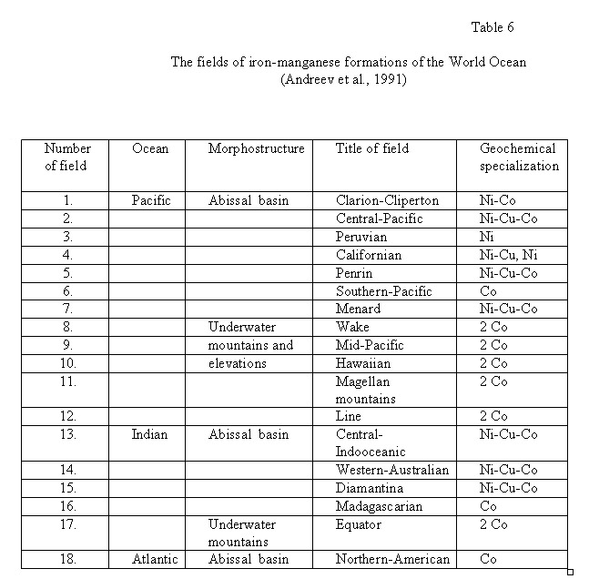 The metalliferous deposits on the composition of ores masses are subdivided into hydroxide, enriched by hydroxide of iron and manganese; and silicates - with essential contents of authigenic nontronite; and as for the composition of unores masses they are selected on carbonates and uncarbonates. The fields of the metalloferous sediments enclosed some known manifestations and deposits of sulphide ores. The scale of dispersion of metalloferous sediments on the flanks of East-Pacific elevations and in the nearest basins is huge. On the total mass of ore substance, contained in them, they are unmeasurably more than all other hydrothermal miniralization. Bores in sedimentary cover, especially on basis horizons, are dissecting the buried metalliferous deposits. Metalliferous deposits accompany the majority of manifestations of hydrothermal activity at the bottom of the ocean and in riftogenic seas of the Red seas type (Baturin, 1970). The enrichment of bottom oozes was related with supply of metals through volcanic exhalation. This possibility appeared natural, because the formation of ocean basins is accompanied by vigorous volcanic activity, particularly in the Pacific Ocean. However, a special geochemical study in the Pacific Ocean has showed the absence of any genetic relationship between ore and the effluents of volcanic emissions (Lisitsyn et al., 1975). Moreover, maps of dispersion halos of iron and manganese (Scornyakova, 1970) and any minor elements (Bostrom, 1971) in bottom sediments show that the source of these metals is not in the central Pacific, where active volcanic is observed, but in its southeastern zone, which is not characterized by intense volcaic activity. Indications from maximal concentrations of these various metals are in the median part of the East Pacific, where a “metal-bearing” zone stretching along the subeguator ridge axis for thousands of kilometres. This zone is a bountiful source of metals, providing vast areas with colossal ore reserves. So we have seen that certain metals are emitted in great quantity during the process of expansion of oceans, especially in relation to mid-oceanic ridges. The geochemical maps which have been composed for the bottom depositions of the Pacific and Indian oceans, allow assuming, that the rate of enriching sediments by ore elements is maximum in those places of mid-oceanic ridges, where the highest rate of spreading and the maximum of the heat stream are being registered (Bostrom, 1971). The complex mineralogical-geochemical and isotopic studies of the problem of ore matter at the Pacific Ocean have allowed to connect its genesis with the process of forming оceanic crust in the axial part of the East Pacific elevation (Origin..., 1973). However, the basalts spatially associated with ore deposits, as a rule, not show either heightened concentrations of metals, or signs of hydrothermal change. Therefore, the source of ore matter for metalloferous sediments is not immediately associated with basaltic magmatism and has diverse nature. The majority of the explorers link them with the recycling of basalts, to wit with leaching by sea waters some more ardent basalts at the depth of 1-2 km and subsequent elevation heated hydrotherms, enriched with ore components, with discharging them at the bottom of oceans under a cold strata of seawaters (Cronan, 1980; Lisitsyn et al., 1990). So we have seen that certain metals are emitted in great quantity during the process of expansion of oceans, especially in relation to mid-oceanic ridges. This phenomenon is so significant that it needs to be discussed in terms of any concept presupposing a global view of the geological evolution of the Earth. It should be noted that none of the ore-forming processes known at present could be considered responsible for the phenomenon in the question. To explain these virtually inexhaustible resources, one is obliged to impute a grandiose source, which is by many orders of magnitude larger than all known ore sources on the continents. * For this purpose we propose considering a process of silication as a possible source of the ore materials in oceans. This process involves intermetallic silicides in the interiors of mid-oceanic ridges. This intermetallic compounds preserve some substantial part of the metallic bond, and hence are capable of forming various alloys as well as solid solutions. For that reason the silicides of magnesium, iron, and other intermetals are able to retain in their lattices large admixtures of various other metals and probably of metalloids as well: phosphorus, carbon, sulphur, and e.t.c. Silicates, on the contrary, do not form alloys with metals, and their ability to form solid solutions is substantially inhibited. The rigidity of the Si-O bond prevents the formation of intrusive structures; and the cation-anion character of the crystal matrix in many cases restricts substitution between elements of comparable atomic radius, by the incompatibility of outer electron shell structures with electronegativity. Hence, the isomorphic capacity of silicate crystal lattices is rather small. The regeneration of silicides into silicates must therefore be accompanied by the evacuation of most other elements. This process releases a large number of “extraneous” (non-petrogenetic) metals and, probably, metalloids as well, because they are not capable of substantial isomorphic substitution in the silicon-oxygen lattice (Larin, 1980). Oceanic ores exhibit quite remarkable compositions. Their siderophilic elements are iron, manganese, cobalt, nickel, and vanadium. Their chalcophilic elements are zinc, copper, lead, silver, and gold. In oceanic sediments their main ore components are represented by the elements that have small affinities for oxygen, a fact which cannot be regarded as mere chance, because silication delivers, first of all, those elements whose oxygen bond energy is low, when oxygen is first available for reaction. According to our model, the supply of ore material to the planetary surface should be fully manifest as late as the mature stage of ocean evolution. At this stage the median ridge has formed and the regeneration of intermetallic compounds into silicates goes on under near-surface conditions directly beneath the rift valley bottom. At first the zone of silication is situated at a depth of more than 100 km and is hidden below the asthenosphere, which prevents persistent zones of tectonic weakness from becoming ore-bearing structures. Hence, ore manifestations gradually diminish downward in the sedimentary oceanic sequence. Consequently, drilling in oceans can reveal rather distinct time boundaries for each ocean, above which deposited ore is constantly a member of sedimentary sequences, while below the boundaries ore diminishes. It should be noted that these boundaries are apt to be closely dated to the emergence of tectonically defined mid-oceanic ridges. It is necessary to dwell the attention on oceanic riftogen zones, putting on the continents. For example, in the Western areas of Northern America, under which «disappear» the East Pacific Elevation, causing rift zones along a vast territory. So, under mountain areas of West of the USA the falling speed of seismic waves in the mantle (7.8 instead of 8.1 km/c) are installed, which testifies to partly disconsolidation of the matter of the mantle (Kherrin, 1972). The power of the continental crust here compounds only 30-40 km. The elevated mountain’s relief of this area, most probably, is connected with disconsolidation of the mantle and it’s hoisting, that is characteristic to the mid-oceanic ridges. Here, the heightened heat stream is being detected, and the nature of seismic is similar to those in the East Pacific Elevation. The enumerated facts allow coming to the conclusion, that the East Pacific Elevation is being submerged under the Western areas of the USA, does not disappear completely, and the processes inherent to the mid-oceanic ridge, are prolonged under continent, but at the major depths. A distinctive feature of these districts Cenozoic gold-silver-polymetallic deposits is hydrothermal – metasomatic type by the absence of its link with magmatic rocks and ubiquity high contents of iron and manganese minerals, places in the industrial amounts (deposits Buitt, East Tintic). V.N.Larin (1980) has expressed an assumption of a possible link of these deposits with processes of silication intermetallic silicides in root’s zones of rift, as the given type of mineralisation coincides in space and time with the phenomena of riftogenetic disintegration that continental province. The problem of mastery mineral’s resources of the World Ocean and, especially, the mining crop of iron-manganese concretions from the bottom of ocean, encompasses all ecological infrastructure of the whole Earth, therefore one of each step on this path should be examined, modeled and accounted for many years toward. 5. MINERAL RESERVES AND RESOURCES OF THE WORLD Меtallogenic examination would be incomplete without the analysis of distribution of the elicited reserves and resources of the useful minerals on geodynamic epochs, cycles and stages, and also for geochemical types including siderophile, chalcophile and lithophile elements (Figure 1). For this purpose, we have attracted the data of distributions of the world resources of mineral raw material during the epochs of mineral formations (Bikhover, 1984); rare and terrerare metals (Solodov, 1980); minerals resources of the World Ocean (Аndreev et al., 1991) and also the newest data on the world reserves of separate useful minerals, made by National department on mineral products of the Ministry of ores and energy of Federal Republic of Brazil (Mineral Summary, 2000) and Geological Services of USA (Minerals Yearbook, Metals and Minerals, 2004). The data of the world reserves of separate useful minerals given below is not quite authentic and correct, since it is summarized from some separate publications. However, the comparison of reserves of some useful minerals from various sources is showing that the sums of reserves is about of the same order, that testifies to sufficient objectivity of the data. In the tables and diagrams, presented below, the reserves of minerals are given in weight quantities and relative percentages on the separate temporary cycles and stages of geodynamic development of the Earth. In order to obtain more objective picture of the distribution epochs of the maximal ore generation of separate kinds of useful minerals, we have summarized the quantity of extracted metals and stayed in bowels of the Earth the reserves and resources of minerals on the time intervals of formation ores deposits. 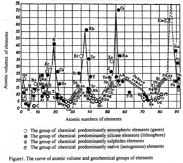 Reprinted with the permission of the Publishing House “Encyclopedia”. 5. 1. S i d e r o p h i l e elements include iron, manganese, vanadium, nickel, cobalt, chrome, platinum, diamonds, graphite and asbestos, the reserves of which are represented on the Table 7 and Figure 3. The analysis of data distribution reserves of iron testifies, that the most favorable epoch of formation iron ores on the Earth was the permobile geodynamic cycle in the interval 3,600-2,000 Ma, in which almost 85 % reserves of iron and 93 % - of graphite are concentrated. The last data of graphite evidences about the domination restorer conditions on the surface of our planet in that time. The reserves of manganese are distributed diametrically to iron, in spite of geochemical affinity between them. The reserves of manganese sharply prevail in newest continent-ocean cycle (200-0 Ma), composing 84 %, whereas in permobile cycle its concentration was about 16 %. It is remarkable, that the distribution of reserves of nickel and cobalt ores is similarly to manganese ores. So, the reserves of nickel and cobalt ores in last cycle accordingly make 95% and 99% with account of huge resources in iron - manganese formations of oceans. On the continents (without the amount of resources of these ores in oceans) the most productive epochs to formation deposits of nickel and cobalt ores were, accordingly, the permobile cycle in connection with greenstone belts (33 % and 67 %) and last Mesozoic-Cenozoic cycle (67 % and 37 %). In all probability, the favorable factors of accumulation of manganese, nickel and cobalt in Mesozoic-Cenozoic epochs are the generation the oceans connected to sharp expansion of the Earth, elevation of intermetalic mantle and mafic magma to the surface, and also domination of oxygenous conditions in the top geospheres of the planet. The distribution of the reserves of chromic (86 %), platinum (74 %) and vanadium (60 %) ores are genetically connected to the largest stratified intrusions of ultrabasic and basic magmatites, that have well-defined early Proterozoic maximum, dated to the early stage of protocontinental cycle. The second less significant peak of reserves of chromic (10 %), platinum (7 %) and vanadium (18 %) ores is connected with late Caledonian stage of geosynclinal cycle of the development. The distribution of the revealed reserves of diamonds represents practical and scientific interest, because it is genetically connected with alkaline-ultrabasic (kimberlite and lamproite) magmatites. The deposits of diamond of the that types are dated to the epochs of tectono-magmatic activaty on the platforms of follow ages: middle Riphean (1,200-1,100 Ma), Devonian (400-360 Ma), Jurassic (180-150 Ma), Cretaceous (120-70 Ma) and Cenozoic (50-20 Ma). Thus, the reserves of diamonds grow from ancient to the younger epochs, making 21 , 19 ,25, 29 and 3.5 % % accordingly. The finds of diamonds in late Archean and Proterozoic conglomerates have mineralogical interest, as an indicator of the displays of more ancient origin sources of diamonds. It is necessary to note, that diamond-bearing epochs coincides with the periods of maximal cratonization of the planet and the origin of Pangea II and Pangea III. The richest diamonds of kimberlite and lamproite deposits are date to Gondwana subcontinent. In our opinion, one of the possible reasons for the increasing of diamond resources in younger epochs of kimberlites in comparison with the ancient, is the rise capacity of restite - the depleted layer on the mantle from where extracted the lithophiles elements, and melting the alkaline-ultrabasic magma from more deep horizons of the spinel- garnet gipolite - the undepleted mantle. At the first sight, it is paradoxical to note the coincidence the peaks reserves of diamonds to reserves of asbestos in Devonian and Cretaceous periods, according to 50 % and 10 %. However it is not surprising, since both of these minerals are genetically connected with ultrabasic magma and testify epochs of activity of the deepest magmatic processes. 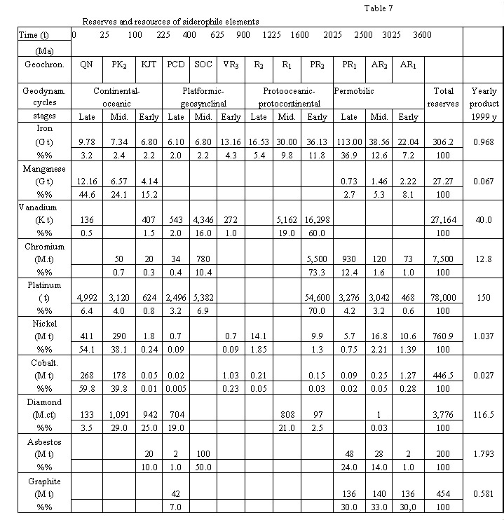 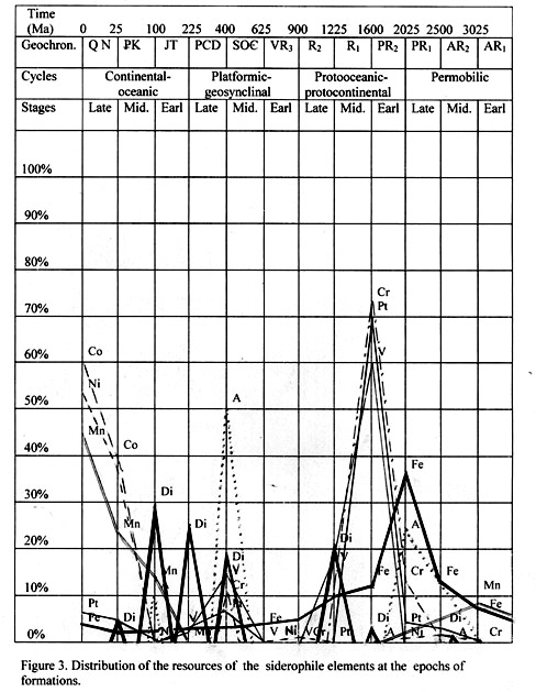 5. 2. C h a l c o p h i l e elements are represented by copper, molybdenum, zinc, lead, mercury, antimony, gold, and also silver. The data on reserves of the chalcophile elements are given in the Table 8 and Figure 4. The deposits of copper are paragenetic connected with various metals in different formation types. Sulphide copper-nickel ores are dated to early Proterozoic differentiated mafic intrusion (Sadbery, Manitoba, Pechenga e.t.c.). There are a lot of copper-sulphide deposits, copper sandstones with the significant content of cobalt (Каtanga-Rodesia copper belt in Africa, Udokan deposit in Siberian) and numerous Mesozoic-Cenozoic copper-porphyritic and copper-molibdenum deposites in the Pacific Ocean copper megabelt. The resources of copper were distributed irregularly. The greatest reserves of copper concern to Mesozoic – Cenozoic Pasific megabelt and Neogene iron - manganous concretions of the Pacific Ocean, accordingly 22 % and 38 %. Copper-sulpfide deposits of late Paleozoic contain about 13 % reserves of copper, and in copper sandstones of late Proterozoic age – 9%. Other reserves of copper are dated to copper-nickel sulphide ores in magmatic deposits of Protorozoic and Archean Age, with about 9 % and 6 % respectively. The deposits of molybdenum are connected with granites and are represented by molibdenit-quartz veins, stockworks, and zones of breaking and less often by skarnes. The prevailing reserves of molibdenum are dated to molibdenum and copper-porphiry formations of Cenozoic age to the West American copper belt (98 % on land). Besides, at the bottom of the Pacific and other oceans the huge reserves of molibdenum (32.2 Mt) are presented in the iron-manganous formations as an impurity. Zinc, lead and silver, frequently together with copper, forming complex polymetallic deposits of hydrothermal, sulphide, skarn, stockwork, sedimentary-metasomatic, stratiform and telethermal types. The maximal reserves of these metals are dated to the latest stages of the two last cycles of geodynamic development of the Earth. Thus, to the Alpine stage of Cenozoic in Mediterranean and West American metallogenic megabelts zinc 23 %, lead 10 %, and silver 42 % of world reserves are dated. The second maximum of resources of these metals is connected with Hercynides tectonic stage of late Paleozoic, where is counted up zinc 32 %, lead 48 % and silver 23 % of world reserves. The considerably smaller resources of the specified metals are dated to Katanga and Kibary stages of Riphean tectonogenes. The gold refers to the noble metals of chalcophile group and is frequently, paragenetic, connected with silver and copper, however distribution of world reserves of gold in time differs essentially. The maximum resources of gold are related to the unique Witwatersrand deposit of sedimentary-hydrothermal-metamorphic genesis on late Archean age. From this deposit is obtained 45,000 t. of gold, and 35,000 t make prognosis resources, that corresponds about 46 % of all world resources of gold. Other less significant reserves of gold coincide with Alpine (18 %) and Cimmerian (27 %) stages of tectonogenes, where hydrothermal and sedimentary deposits of gold represent them - quartz, gold - silver, gold – blackschist and gold placers formations. 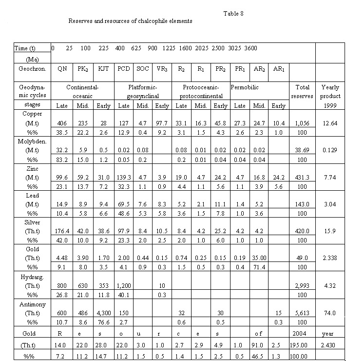 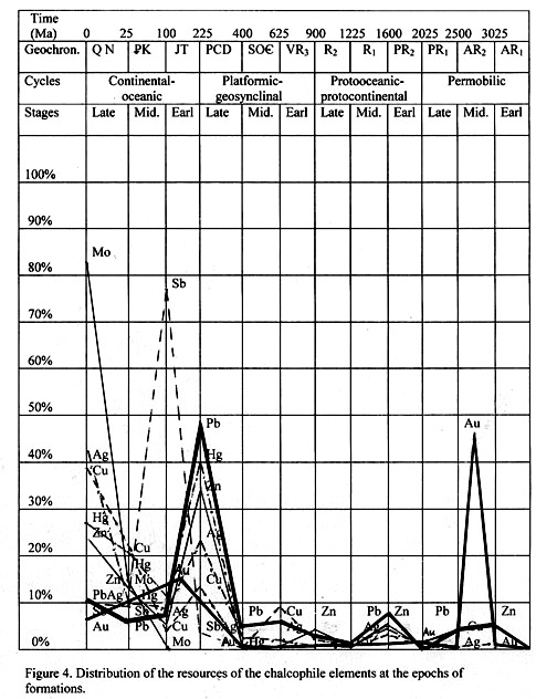 Mercury and antimony are complementary metals that meet commonly together in variable amounts in deposits of hydrothermal genesis. The maximum reserves of mercury are dated to the late stages of two last geodynamic phases and are connected to the late Hercynian (40 %) and Alpine (48 %) tectonogenetic stages. The reserves of antimony in time intervals were distributed a little differently, because the richest late Cretaceous deposits of Southern China, containing about 77 % of world reserves of antimonies, whereas 19 % of antimony is related to the Alpine stage. However, it is not excluded, that the age of the Chinese deposits of antimony is more ancient (late Hersynian), since their presence between Devonian and Triassic depositions without any clear connection with Cretaceous granites and are controlled by large breaks zones. As a result of the spent analysis of the distribution reserves of metals of the chalcophile group, it is possible to make a conclusion, that maximum resources of these metals are connected with the late stages of the two last cycles of geodynamic development of the Earth (late Hercynian and Alpine), that was caused by epoch of the maximum expansion of the Earth and activity of tectono-magmatic processes. The exception makes the unique richest Witwatersrand deposit of gold of late Archean age and, perhaps, the antimony deposits of Cretaceous age (?) on Southern China. 5. 3. L i t h o p h i l e elements are represented by tin, wolfram, aluminium, uranium, thorium, niobium, tantalum, fluorine, potassium, sodium, barium, lithium, rubidium, cesium, beryllium, strontium, radium, yttrium, cerium, zirconium and other rare metals, the reserves of which are given in the Table 9 and Figure 5. Tin and tungsten are complementary metals and more often usually found in the deposits of hydrothermal, greisens, pegmatite, stockwork and skarn types genetically connected with acid granitoides. The maximum reserves of tin (60 %) and tungsten (73 %) are dated to Cimmerian stage of tectogenesis, less - to Alpine (10 % and 15 %) and the late Hercynian (18 % and 9 %) stages, the deposits of which are territorially disposed in external zones of the Pacific Ocean metallogenic megabelt. Aluminium, basically, is extract from bauxites, which formed at lateral chemical weathering of various rocks in conditions of the humid tropical climate on the continents, or from deposition of weathering products in the littoral zone of the seas. Four epochs of weathering of bauxites are known in the geological history of the Earth. The reserves of the bauxites were distributed in such manner that the most productive of them appear to be the late Palaeogene-Holocene bauxites, containing 88 % of the world reserves, less in the middle Devonian-Carbon - 7 %, Cretaceous - 4 % and early Cambrian bauxites- 1 %. The formation of bauxites originated at the times of tectonic rest and formation of the peneplains. Uranium. More than half account reserves of U3O8 on the planet is dated to Precambrian epoch – 54%, and less in Paleozoic - 12 %, then in Mesozoic - 24 % and in Cenozoic formations - 10 % are included. To magmatic deposits of uranium (mainly in acid and alkaline granites and pegmatites) are related 6-7 % of reserves. In the late Archean and early Proterozoic uranium - gold metamorphic conglomerates and quartzstones are included 15 %; in the hydrothermal and infiltrational stratiformal deposits of discordant type there are more than 48 % reserves of uranium. The remain resources of uranium are contented in carbonatites, skarns, bituminous schists and placers deposits. From 13 well-known epochs of uranium formations, the most productive are Kenoran, Guron, Gudson, Katanga, Hercynian, Alpine and Caucasian. The most importance epoch of uranium metallogeny find out when all the uranium ores (already found, reserves and resources) are taken into account. So, according to the data of М.V.Schumilin (1996), only 63 % of the world resources of uranium are connected to Protozoic epoch. Table 9 Reserves and resources of lithophile elements 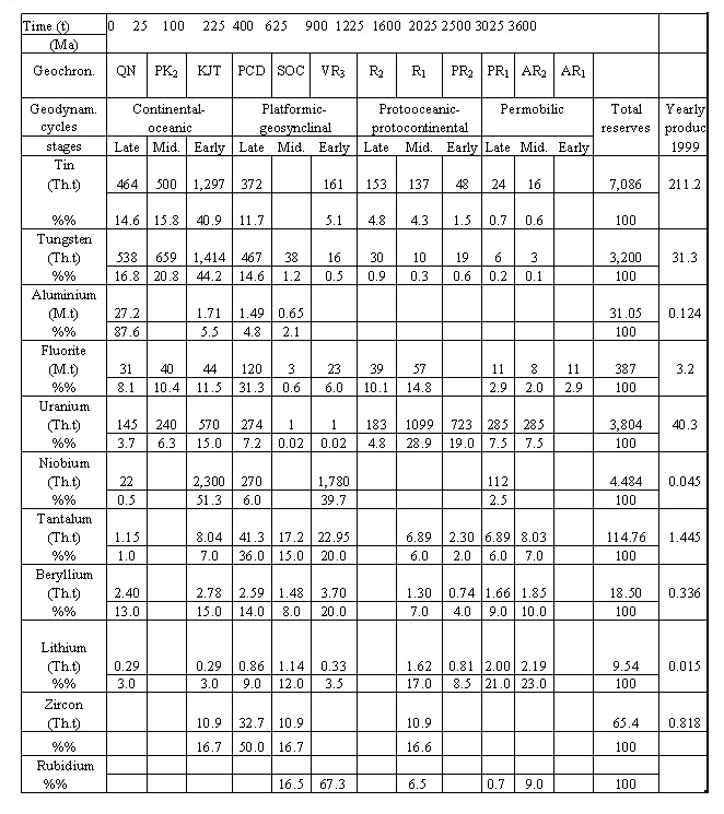 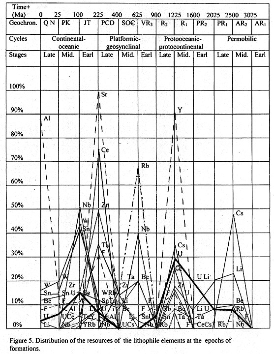
The significance of the geological history of the Earth in Proterozoic period from positions of uranium metallogeny are the level of "maturity" of continental crust, shielding of cratogenic fundament by powerful cover of sedimentary rocks and increasing of partial pressure of oxygen in the atmosphere. The cosmos rhythms are not crucial for formation of large deposits of uranium (Lyachnitskiy, Markov, 1996). It is characteristically the connection of uranium epoch to the marked above final stages of geotectonic cycles. They are accompanied by raising the continents and regressing the seas, that is to say, with geocratonic conditions, especially at formation the supercontinents of Pangea I, II, III, accordingly, after Karelian (1,900-1,700 Ma), Grenville (1,100-900 Ma) and Hercynian (290-230 Ma) epochs of foldering. It is necessary to note, that 63 % of large deposits of uranium is located on the supercontinent Laurasia and only - 37 % on the Gondwana. Thorium is genetically connected to sodium granites, syenites and pegmatites, in which it is attended as accessory thorium contents minerals. Besides, there are rare pneumatolytic and hydrothermal deposits of thorite in association with barite, fluorite, hematite and other minerals. The industrial contents of thorium are established in some gold – uranium metamorphic conglomerates and quartzstones of early Proterozoic age, for example, in the deposit Blind-River (Canada), where the reserves of ThO2 about 3,300 t are calculated. For the account of denudation all primary sources of thorium are formed rich alluvial and seacoast placers deposits of monazite in Southern India and Brazil, which are the basic raw material for manufacture of thorium. It is interesting to note, that 75 % of the discovered large deposits of thorium are located on the continents Gondwana, whereas 25 % - on the continents of Laurasia. Rare, dissipated and terra-rare elements have brightly expressed lithophile geochemical specialization. The rare metals Ta, Nb, Be, Li, Rb, Ce, Sc, Zr, Hf, B; dissipated elements - Cd, Ga, Ge, Tl, Re, Se, Te, In; terra-rare elements №№ 58-71 lanthanum both cerium groups and Y are represented. General part of these specified elements is dated to the crust alaskites and subalkalines granites and genetically connected with them pegmatites, greisens and metasomatites with raised alkaline. The next one of most significant sources of these elements is geocratonic conditions, especially at formation of uniform supercontinents Pangea I, II, III, accordingly, after Karelian (1,900-1,700 Ma), Grenville (1,100-900 Ma). Rare, dissipated and terra-rare elements have brightly expressed lithophile geochemical specialization. The rare metals Ta, Nb, Be, Li, Rb, Ce, Sc, Zr, Hf, B; dissipated elements - Cd, Ga, Ge, Tl, Re, Se, Te, In; terra-rare elements №№ 58-71 lanthanum both cerium groups and Y are represented. The most part of these specified elements is connected with alaskites and subalkalines granites and genetically connected with them pegmatites, greisens and metasomatites with raised alkaline. The next one significant sources of these elements is mantle rare metals alkaline granites, carbonatites, miaskites, agpaite nepheline syenites and metasomatites. Metamorphic, placers deposits and, especially, exogenic sources, such as mineralized natural waters and salt-water have an important value for industrial production of many rare elements. As judged by the discovered reserves of these metals (Solodov, 1980), three basic metallogenic epochs of rare metal are being emphasized: Sumian - on the boundary of Archean and Proterozoic (2,6-2,4 Ga); than Grenville - in medial Riphean (1,2-1,1 Ga); and Kimmerian - in Mesozoic (230-140 Ma) (Table 9, Figure 5). On the continents the early Proterozoic rare elements deposits are located on Archean shields; middle Riphean - within the limits of ancient platforms, and Mesozoic – on the Precambrian middle missives, young platforms and less in geosynclinals belts. It is necessary to note, that rare metal deposits more often meet on Laurasian continents in comparison with Gondwanian, approximately in the proportion of 3:1. This fact testifies to the irregular spatial dislocation of these rare metals on the planet, as well as uranium and thorium. Меtallogenic epochs of rare metal are precisely dated in time and in space to the periods of tectono-magmatic activity after a long period of tectonic rest on the continents. The close geochemical connection of the rare lithophile elements and alkalines, especially potassium, testifies to the unified deep source. On the opinion of V.N.Larin (1980), the juvenile source of lithophile rare and alkaline metals, it is necessary to consider the pyrolite layer of the mantle. Extraction of rare metals from pyrolite is carried out by deep intertelluric fluid, the occurrence and character of which is determined by degassing of hydrogen from the core of the Earth. The increasing amount of rare metal in the areas of tectono-magmatic activity is caused by accumulation in upper mantle the layer of pyrolite in connection with the expansion of the Earth, appropriated fall of gravity, reduction of gradient of pressure in mantle and transformation spinel-garnet in olivine-pyroxene (pyrolite). It is accompanied by “lattice downthrou” of isomorphous impurity of lithophile elements. At the establishing of intertelluric fluidic flow these elements are exposed by "flotation " and are involved in processes of formation rare metal ores in the upper parts of terrestrial crust. Thereby, the consideration of evolution terrestrial crust and upper mantle of the continents on the basis of the hypothesis of the primordial hydridic Earth, allows us to come closer to the understanding of the internal reasons determining legitimacies of the distribution of lithophile rare metals in time and in space. 5. 4. O c e a n i c o r e g e n e s i s. The lamination of external geosphere of the Earth on the crust, pirolite and gipolite with rather contrast distribution in them potassium, rubidium and, accordingly, radiogenic strontium caused in the past time the contrast between the geochemistry character of the allocation these elements in the zone of sedimentation at the depending from process of ocean formation, which resulted to consequent disclosure of more and more deeper horizons of the planet. The carbonates of calcium fix the isotope composition of strontium in the water, from which they are fallen out, that allows to consider the evolution of the ratio 87 Sr/ 86Sr in the ocean’s water of the Earth. The curve, describing the evolution of isotope composition of strontium in the oceans on the time, has appeared rather singularity (Figure 6). Three cardinal perturbations are clearly prominent on it, which, obviously, reflects essential changes of the image of the Earth. The data show exponential increasing of the relation 87Sr/ 86Sr in waters, circumfluent of the planet during the period from 3,0 up to 1,1 Ga years back. The extrapolation of this curve untill now has resulted to the modern value of the isotopic relation of strontium in continental crust. However, in late Precambrian, approximately on the boundary of middle and upper Riphean, this relation sharply deviates from the exponential dependence (perturbation А) that testifies to the appearance of a source with the low isotope attitude of strontium exposed on extensive territory. According to V.N.Larin (1980), it is, most probably, connected with the beginning of active ocean formation, during which low potassium has emanated the tholeiite basalts in huge amounts, what accompanied the formation of oceanic depressions. It is possible to connect the sharp failure of the curve (perturbation В), coming on the end of Paleozoic and beginning of Mesozoic, with the acceleration of processes of ocean formation in Mesozoic era, when there was disclosure the Atlantic and Indian young oceanic depressions alongside with proceeding expansion of the existing Pacific Ocean. The acceleration of the ocean formation, connected with expansion of the Earth, by all means should cause the strain, and at the end the break of mantle layer restite in middle part of the ocean couch, accompanied by rise and output on the surface the again formed silicate mattress of the layer B, arising by the way of metasomatism of the intermetalic layer C of the upper mantle. The content of Rb in intermetalic connections of the layer C should indicate initial concentration of this element on the planet and, hence, should not be less, than in gipolite. In this connection, the sharp increase of the relation 87Sr/86Sr in oceanic carbonate sediments (perturbation С) is explained. At the pressure of level 10 GPа and above, the formed silicate mattress should be represented by spinel-garnet mineral association, whereas at reduction of pressure will prevail ever more pyroxene-olivine paragenesis. As far as the isomorphic capacity of lattices olivine and pyroxene is much lower, than at garnet and spinel (in the attitude of potassium, uranium and others lithophile elements), that the change of mineral paragenesis, formed by metasomatic way in the bowels of mid oceanic ridges, necessarily should be accompanied by increasing gab of these elements. Just here it is possible that huge source which was caused the late Jurassic perturbation C in geochemistry of potassium and strontium in the zone of sedimentation at the bottom of oceans of the Earth (Larin, 1980). Deep-water red clays of pelagian parts of the oceans along with the high contents of ores elements have the sharply increased concentration of potassium and uranium. In the light of what has been stated above, it should be connected, as far as the ores matter, to axial parts of oceans, with process of silication intermetalic joints of the upper mantle. Admit the community of sources for these elements and ores matter, and also the same cause of conditionality of characteristic "failures" on the curve evolution potassion and radiogenic strontium in Mesozoic-Cenozoic, it is possible to involve the data of isotopic strontium for defining the time of the beginning of entrance ores matter through the axial zone of oceanic couch. According to the curve, reflecting variation of the relation strontium at ocean during the Phanerozoic (Figure 7), the first portions of ores matter could begin to enter from the end of late Jurassis time (150-140 Ma), and from the beginning of Cenozoic the process of endure of ores matter has become more intensive. However, we should keep in mind, that the given estimate is received on waters of the World Ocean and, apparently, reflects the time of occurrence ores matter in the Pacific Ocean depression. It was established before other oceans and, accordingly, earlier in it the processes of ores generation were caused by approach to the surface of the planet, the zone of silication should have started. Other oceans could enter this stage of development much later, therefore the fields of iron - manganese formations, copper-nickel-cobalt, sulphide-polymetalic and others ores are less developed. 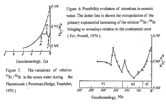 Finishing the brief review of evolution of the oceans, it is necessary to dwell on the problem of sources of water in the Earth. Some researchers assume that water has space origin; other scientists admit the jevenilic source of waters connected with the magmatic processes and volcanic degasation. However, the appearance of oceans on the Earth since the middle Riphean time, their intensive development in Paleozoic and, especially in the Mesozoic-Cenozoic period, makes it difficult to connect it to the mentioned above sources of water. According to the hydridic conception, free water would appear only in the degassing fluids when the silicate-oxide layer of the planet was completely formed. This most probably occurred at the end of the Archean, when the early, areal granulite, anhydrous metamorphism was completely replaced by hydrous amphibolites. Thus, the superficial hydrosphere had appeared and could permanently exist only from the end of Archean. Since then the hydrosphere has steadily grown. The scale of this growth in the Mesozoic and Cenozoic can be evaluated with the aid of oxygen isotopes. Ocean water isotope distribution at present is usually taken as the standard: 18O=0 in seawater. If we make the assumption that during the Mesozoic and Cenozoic, a 200 meter thick layer of marine sediments with 18O= +30 o/oo had accumulated, then 1000 meter deep layer of juvenile water with 18O= +6 o/oo should be added to the hydrosphere in order to preserve the oxygen isotope distribution in the ocean water at the observed lever. Thus, ocean volume would have had to increase approximately fifty percent during this period (Larin, 1993). From the positions of the hydridic conception, the cause of appearance huge quantity of ocean water is the intensive decomposition of the hydridic core in Phanerozoic and degasation of hydrogen, which during the process of rising to the surface of the planet took out from mantle and lithosphere oxygen. Both of these elements in the upper surface condition are connected together forming the water, that filling the oceanic depressions, arising during the expansion of the Earth. CONCLUSION The reduction of time intervals of the geological-tectonic cycles and stages from the protoplanet stage until nowdays, based on the conception of the primordial hydridic Earth, is explained by gradual decrease of volume the hydridic core. Each cycle begins by warming up and decomposition of hydrides in the external sphere of the internal core, that causes warming up and increase the pressure of hydrogen in the external core. This process causes degassation of hydrogen and subsequent decompression the external zone of the core. Therefore, with each cycle the borderlines of the external and internal core remove to the center of the planet at some certain interval. But the volumes of matter involved in decomposition of the hydridic core have shortly decreased from early cycles to the latest cycles. Consequently the time of degasation and decompression should be reduced, to wit the continuance of cycles of decomposition of hydridic core and correspondingly the tectono-magmatic cycles should be decreased. Nowadays, the internal core makes less than 1 % of the volume of the planet, and it is natural to suppose, that the faster expense of hydridic reserves in the core necessarily will cause the contravention of habitual cycles in future of the Earth. In this plan it is possible, that the Alpine cycle are the last full processed geodynamic cycle of the development of the Earth. One may be suppose that the present stage is transitive to a new type of the geodynamic regime, which will come from the moment of complete depletion of the hydridic reserves of the planet, to wit from the moment of disappearance of the internal core of the Earth. The concept of the primordial hydridic Earth, that is developed by V.N.Larin (1980) represents highly perspective, since it is based on the precise cosmochemistric laws and will be coordinated to the modern data on physics of the core and mantle of the planet, simplifies the solution of the problem of geomagnetism and cycles of development the planet. Most important, that on the basis of one leading process of cyclic degasing hydrogen at the warm up and decomposition of the hydridic core, it is enable to coordinate all the wide spectrum of the global geological phenomena (formation of oceans, geosynclines, platforms, epochs of tectono-magmatic activities and processes of oregenesis, connected to them), and come closer to the understanding of the reasons of evolution of the geodynamic regime during entire geological history of the Earth, from the earliest stages to the modern time. Especially, it is necessary to emphasize, that the hydride hypothesis "forces to work " globe in all its volume - from the internal core up to terrestrial crust. This realization opens grandiose prospects in its practical application to research the past, present and predict the future of our planet. The task of the new ХХI century will be the creation of any uniform theory of evolution of the Earth, on the basis of which, the problems of metallogeny and searches of mineral deposits will be decided. The " Metallogenic map of the geodynamic systems of the pulsating-expanding Earth " and the “Explanatory note", proposing to the attention of the geologists, is the first attemption to the solution the problems of metallogeny on the basis of hydridic concept of the Earth. REFERENCES Аller L., Abundance of Chemical Elements. – Izdat.inostran.liter., Moscow, 1963, p. 357. (in Russian). Ainemer A.I., Konshin G.I., Placers of the Shelf Areas of the World Ocean. - Leningrad., Nedra, 1981, p. 261. ( in Russian ). Andreev S.I., Anikeeva L.I., Ainemer A.I., Ivanova A.M., Krasnov S.G., Khramosta I., Rosenkranz O., Explanatory Text to the Map of the Mineral Resources of the World Ocean (1: 25,000,000). – St.Petersburg - Prague, 1991, p. 69. ( in Russian ). Andreev S.I., Metallogeny of Iron-Manganese Formations of the Pacific Ocean. – St.Petesburg, Nedra, 1994, p. 191. ( in Russian ). Andreev S.I., Gramberg I.S., Krasny L.I., Shcheglov A.D., Main Features of Geology and Minerageny of the World. - VSEGEI, St.Petersburg, 1997, p.43. ( in Russian). Baturin G.N., Deep-Water Ore Deposits of Hydrothermal Origin. In book: “History of the World Ocean”. Nauka, Moscow.,1971, pp. 257-277. ( in Russian ). Belousov V.V., The Earth Crust and Upper Mantle of Continents. – Nauka, Moscow, 1966, p.123. ( in Russian ). Belousov V.V., The Earth Crust and Upper Mantle of Oceans. – Nauka, Moscow, 1968, p.255. ( in Russia ). Betekhtin A.G., Mineralogy. – Izdat.geol.liter., Moscow.,1950, p.952. ( in Russian ). Betelev N.P., On Presence of Hydrogen in Natural Gases in the Southeastern Ust’urt.- Doklady Akad. Nauk USSR, 1965, vol.161, N 6, pp. 1422-1425. ( in Russian ). Bilibin Ju.A., Metallogenic Provinces and Metallogenic Epochs. – Moscow., Gosgeoltechizdat, 1955, p.86. ( in Russian). Bikhover N.А., Distribution of the World Mineral Resources on Epochs of Ores Formations. – Moscow., Nedra, 1984, p. 576. ( in Russian ). Bolt B.A., The Fine Structure of the Earth’s Interior. – Scientific American, 1973, vol. 228, N 3, pp. 24-33. Bostrom K., Origin of Sediments in Active Ridges in the Indian and Pacific Oceans.- Theses for International Geochemical Congress. Moscow, vol. 2, 1971, pp. 806-807. Bostrom K., Origin and Fate of Ferromanganesian Active Ridge Sediments. – Stockholm, Contrib. Geol., 1973, vol.27, N 2, pp.149-253. Carey S.W., Theories of the Earth and Universe. A History of Dogma in the Earth Sciences. - Stanford University Press, California, 1988, p.447. Cherkashov G.A., Krasnov S.G., Egiazarov B.Kh.,Ainemer A.I., Ashadze A.M., Opekunov A.Ju., Hydrothermal-Sedimentary and Hydrothermal Formations in the World ocean. - Moscow, VIEMS, 1985, p. 66. (in Russian). Glukhovskiy M.Z., Pavlovskiy E.V., On the Problem of Early Stages of the Earth’s Evolution. – Geotektonika, 1973, N 2, pp. 3-7. (in Russian ). Сondy K., Archean Greenstone Belts.- Moscow, Izdat. Mir, 1983, p. 390. (in Russian) Cronan D.S., Introduction: Metallogenesis at Oceanic Spreading Centers. -J. Geol. Soc., 1980, vol. 137, part 4, pp.369-372. Explanatory Note to " Меtallogenic Map of the World Ocean " (scale 1:10,000,000), editor-in-chief Andreev S.I. – St.Petersburg., Rotoprint VNIIOkeangeologia, 1998, p.211. (in Russian). Faure G., Powell I.L., Isotope Strontium in Geology.- Moscow., Izdat. Mir, 1974, p.214. ( in Russian ). Galaktionova N.A., Hydrogen in Metals. – Metallurgiya, Мoscow., 1967, p.303. ( in Russian ). Gerhardt Ch. F., Introduction a ' L'etude de la Chimie par le Systeme Unitaire, Paris, 1848. Grambling J., Pressures and Temperatures in Precambrian Metamorphic Rocks.- Earth Planet. Sci. Lett., 1981, v.53, pp. 63-68. Geodynamic Map of the World, scale 1:45,000,000, editor Smislov A.A. – VSEGEI , Leningrad.,1987. ( in Russian ). Geodynamic Map of Russia., scale 1 : 10,000,000, editor Smislov A.A. – Goskomvus, 1996. ( in Russian ). Geological Map of the World, scale 1:15,000,000, editor Nalivkin D.V. -VSEGEI , Leningrad., 1970. ( in Russian ). Geology and Mineral Resources of the Antarctica.- Works VNIIOkeangeologia. - Мoscow, Nedra, 1990, p. 232. ( in Russian ). Gerhardt Ch.F., New Chemical Etudes of Unitary System. – St. Petersburg., 1865. ( in Russian ). Grigorjeva L.V., Precambrian Tectono-Magmatic Activity (Geology and Metallogeny).- Leningrad., Nedra, 1986, p. 224. ( in Russian ). Grinson A.S., Formation and Dislocation Kimberlites in East part of the Siberian Platform in Connection with Features of its Deep Structure. - Izv. АS USSR, ser. geol., M.,1984, N 3, p. 54-65. ( in Russian ). Grozdilov A.L., Harmonic Analysis of Waving Movements of the Terrestrial Crust. - In the book.: Problems of geology of the polar areas of the Earth. NIIGA, Leningrad, 1974, pp. 47-54. ( in Russian ). Gusev G.S., Zaykov V.V., Zaykova E.V., Kovalev A.A., Leonenko E.I., Mejelovsky N.V., Mints M.V., Rundquist D.V. (scientific editor).- Bases of the Metallogenic Analysis of the Geological Cartography. (Metallogeny of Geodynamic Backgrouds). - Мoscow, Roskomnedra, Geomap, MANPO, 1995, p. 468. (in Russian). Gutenberg B., Physics of Earth Interior. – Izdat.inostr.. liter., Moscow., 1963. p.263 ( in Russian ). Herrin E., Regional Changes of Р-wave Velocity in the Upper Mantle Beneath the North America. - In book: The earth’s crust and upper mantle. - Мoscow, 1972, pp. 198-202. (in Russian). Hoyle F., About the Origin of the Solar Nebula.- Questions of cosmogony. Moscow, 1960, edit.. 7, p. 15-49. (in Russian). Ivanov M.K., Krutoyarskiy M.A., Spiral Structures of the Lithosphere and Prognosis of Metallogenic Region. - Actual directions of metallogenic research. – Theses of the reports of scientifically practical conference. VSEGEI, Leningrad., 1988, pp. 40-41. ( in Russian ). Isaev E.N., On Viscous Flow of the Asthenosphere below Island Arches. – Doklady Akad. Nauk USSR, 1969, vol.184, N 2, pp. 406-409.(in Russian). Khain V.E., The Geosynclinal Process and Evolution of Tectonosphere. – Izv. Akad. Nauk USSR, ser.geol., 1964, N 12, pp.3-17. ( in Russian ). Khain V.E., Whether there is a Scientific Revolution in Geology? - Nature, N 1, Moscow, 1970, p.7-19. (in Russian). Khain V.E., Regional Geotectonic. Oceans. Synthesis.- Nedra, Moscow,1985, p.292. (in Russian). Khain V.E., Bojko N.A., Historical Geotectonic. Precambrian. - Nedra, Moscow, 1988, p. 382. (in Russian). Khain V.E., Seslavinsky K.B., Historical Geotectonic. Paleozoic.- Nedra, Moscow,1991. (in Russian). Kozlov N.N., Eneev T.M., Numerical Modelling Processes of Formation Planets from the Protoplanet Cloud.- Preprint institute of applied mathem. AS USSR, Moscow, 1977, p. 80. (in Russian). Krasny L.I. Problems of Tectonic Systematic. – Moscow., Nedra, 1977, p.174. (in Russian). Krasny L.I. About the Great Pacific Ocean Geosection. – Reports AS USSR, 1978, N 5, pp.1148-1150. ( in Russian ). Krasny L.I.. Global System of Geoblocks.- Мoscow, Nedra, 1984, p. 223. (in Russian). Krutoyarskiy M.A., Principles and Methods of Drawing up the Map of Diamond Prognosis in Northeast part of the Siberian Platform. – In book.: " Principles and methods of drawing up the prognosing maps " - Мoscow, 1966, pp. 57-66. (in Russian). Krutoyarskiy M.A., About some Kimberlites bodies of the basin river Omonoos of region Olenek. – Zapisky VMO Akad. Nauk USSR, p.87, edit.2.- Moscow - Leningrad, 1958, pp.166-180. (in Russian). Krutoyarskiy M.A., Milashev V.A., About the Dependence of Morphology of Diamond Crystals from Facial Conditions of Formation Kimberlites of the Siberian Platform. – Zapisky VMO Akad. Nauk USSR, p. 83, edit.6, Moscow - Leningrad, 1964, pp. 697-703. (in Russian). Krutoyarskiy M.A., Makar’eva E.M., Metallogenic Regions of the Northeast part of Peninsula Taymyr.- Izdat. Sevmorgeologia, Leningrad, 1989, pp. 93-109. (in Russian). Kudryavtsev V.E., Possibility Reasons of Formation an Unique Uranium Deposits in Proterozoic. – Izdat. VSEGEI J. Region. geol. and metallogeny, N 5, St-Petersburg, 1996, pp. 136-144. (in Russian). Kulinkovich A.E., Physical Models of Galactic Geology. - Conceptual bases of geology.- Zapisky St.-Petersburg Gorny Institute, 1992, v.134, pp. 87-94. (in Russian). Kuroda P.K., The Time Interval between Nucleosynthesis and Formation of the Earth. - Geochim. et cosmochim. acta, 1961, v.24, pp. 40-47. Larin V.N., The Hypothesis of a Primordial Hydridic Earth.- Moscow, Nedra, 1975, p.101. ( in Russian). Larin V.N., The Hypothesis of a Primordial Hydridic Earth. – Second edition, reworked and supplemented. Moscow, Nedra, 1980, p.216. (in Russian). Larin V.N., Hydridic Earth: the New Geology of our Primordially Hydrogen Rich Planet.- Polar Publishing , Calgary, 1993, p.247. Lazarenkov V.G., Malich L.N., Sahyanov L.O., Platinummetallic Mineralization in Zonal Ultrabasic and Komatiites Massives. – Leningrad, Nedra, 1992, p. 217. (in Russian). Leontjev О.К. Marine Geology. -Мoscow, Top School, 1982, p. 344( in Russian). Letnikov F.A., Fluid Regime in Tectonic Zones. – Degazatsiay Zemli i Geotectonika, Symp. Theses, Moscow, 1976, pp. 30-32. ( in Russian ). Letnikov F.A., Particulars of Fluid Regime of Endogenous Processes in the Crust and Mantle. – Fluidniy Rezhim Zemnoi Kory i Verkhey Mantii, Symp. Theses, Irkutsk, 1977, pp. 5-9. ( in Russian ). Lisithin A.P., Bogdanov Ju.A., Gurvich E.G., Hydrothermal Formations of Rift Zones of the Ocean.- Moscow, Nauka, 1990, p.256. (in Russian). Lutz B.G., Chemical Composition of Continental Crust and Upper Mantle. – Moscow, Nauka, 1975, p.166. ( in Russian ). Lyachnitsky Ju.S., Markov K.A., Connection the Epochs of Formation Useful Minerals with the Periods of Galactic Year. - Problems of research of the Universe. Edit. 19, p.2, New ideas in natural sciences. – St.-Petersburg, 1996, pp. 240-246 ( in Russian). Mackay K.M., Hydrogen Compounds of the Metallic Elements.- Spon Limited, London, 1966, p. 239. Magakyan I.G., Metallogy (the Major Ores Belts).- Мoscow, Nedra, 1974, p. 304. (in Russian). Mаlich N.S. (editor-in-chief)., Explanatory Note to Metallogenic Map of the Siberian Platform (1:2,500,000). – Leningrad., VSEGEI, 1989. (in Russian). Map of the Useful Minerals of Continents of the World ( scale 1:15, 000 000). Editor Tatarinov P.M. – VSEGEI, Leningrad, 1970. ( in Russian ). Map of the Mineral Resources of the World Ocean ( scale 1:25,000,000 ) with Explanatory Text. Editor-in-chief Gramberg I.S. - St.-Petersburg -Prague, 1991. ( in Russian). Marakushev A.A., Perchuk L.L., Origin and Evolution of Trans-Magmatic and Metamorphic Fluids. – Intern. Geochim. Congress, Moscow, 1972, vol. 3,1. pp.3-14. ( in Russian ). Marakushev A.A., Perchuk L.L., Thermodynamic Model of Fluid Regime of the Earth. – Ocherki Fiziko-Khimicheskoi Petrologii, Moscow, 1973, vyp. 4, pp. 102-130. ( in Russian ). Marakushev A.A., Origin of the Earth and the Nature of its Endogenic Activity. – Moscow, Nauka, 1999, p.255.( in Russian). Markov M.S., Particulars of Development of the Earth’s Crust in Early Precambrian.- Geologiya i Petrlogiya Dokembriya, Moscow, 1962, pp.70-76. ( in Russian ). Masaitis V.L. (editor), Mashchac M.S., Raichlin A.I., Selivanovskaya T.V., Shafranovsky G.I., Diamondbearing Impactites of the Popigai Astrobleme. – St.-Petersburg: Izdat. VSEGEI, 1998, p.179. (in Russian). Мilanovskiy Е.Е., Pulsation and Expansion of the Earth – the Possible Key to Understanding its Tectonic Development and Volcanism in Phanerozoic.- Moscow, Nature, 1978, N 7, pp. 22-34.( in Russian). Мilashev V.A., Kimberlites and Deep Geology. - Leningrad, Nedra, 1990, p.167. (in Russian). Мilashev V.А., Environment and Processes of Formation of Natural Diamonds. – St.-Petersburg, Nedra, 1994, p.144. (in Russian). Mineral summary., National department. of Mineral Production. - Brazil, v.20, 2000, р.120. Мineralogeny of the Arctic region. – Gigest of scientific works VNIIOkeangeologia, St.-Petersburg, 1994, p. 177. ( in Russian ). Моnin A.S., Katarchean.,. – Geology and Geophysics, 1983, N 7, p.3-15. (in Russian). Оleynikov B.I., Okrugin A.I., Leskova N.V., Petrologic Value of the Finds of Native Aluminium in Basites.- Doklady Akad. Nauk USSR, 1978, N 1, p. 191-194. (in Russian). Origin of Metalliferous Sediments from the Pacific Ocean., - J. Dymond, J.B. Corliss, G.R. Heath, C.W.Field, E.J.Dasch, H.H.Vech. - Geol. Soc. of America bull., 1973, v.84, N 10, p.3355-3371. Pavlovskiy E.V., Origin and Development of the Continent’s Earth Crust. – Geotektonika, 1975, N 5, pp.3-14. ( in Russian ). Pavlovsky E.V., Gluchovskoiy M.Z., Problems of Thermotectogenesis.- Geotektonika, 1982, N 6, p.7-25. ( in Russian ). Pavlovsky E.V., Gluchovskoiy M.Z., Problems of Thermotectogenesis.- Geotektonika, 1975, N 5, pp. 3-17. ( in Russian ). Peive A.V., Tectonica of the Middle-Atlantic Ridge. ( in Russian ). Peterman Z. E., Hedge C.E., Tourtelot H.A., Isotopic Composition of Strontium in Sea Water Throughout Phanerozoic Time. - Geochim. et Cosmochim. acta, v. 34. 1970, p. 105 - 120. Pinsky E.M., About the Planetary Laws of Metallogeny Uranium.- Region. geol. and metallogeny, 1999, N 8, p.100-107. ( in Russian ). Poletavkin I.G., Space Energetics.- Мoscow., izd. Nauka, 1981( in Russian). Ramdohr P., Neue Beobachtungen an Erzen des Witwatersrands in Sud Africa und ihre Genetische Bedentung.- Berlin, Acad. Verlag, 1955, p. 44. Rititake T., Electromagnetism and the Earth’s Interior, Elseyier. –Nedra, Leningrad, 1968, p.331. ( in Russian ). Salop L.I., Geological Development of the Earth in Precambrian. - Leningrad., Nedra, 1982. ( in Russian ) Sheinmann Yu.M., Essays of Deep Geology.- Nedra, Moscow, 1968, p. 231. ( in Russian ). Smirnov S.S., About the Pacific Ocean Ores Belt. - Izvestie AS USSR, series geolog., N 2, 1946. ( in Russian ). Smirnov V.I., Metallogeny of Geosynclinals. - Izdat. AS USSR, Moscow, 1962, p. 178-181. ( in Russian). Smyslov A.A., Geodynamic Systems of Lithosphere. - In book.: Deep structure and geodynamics of lithosphere.- Nedra, Leningrad, 1983, p. 208-235. Works VSEGEI, new series, p. 317. ( in Russian ). Smyslov A.A., Geodynamic Systems of the Earth and their Evolution. – St.-Petersburg. Mining institute. In book: New ideas in science about the Earth. – Publ. MGGA, Moscow.,1998, p.326. ( in Russian ). Skornyakova N.S., Dispersed Iron and Manganese of the Pacific Ocean. – Osadkonakoplenie v Thihom Okeane, Moscow, 1970, pp.159-202. (in Russian). Solodov N.A., The Main Types of Deposits of Rare Lithosphere Metals and their Role in Mineral-raw Base - In book: Ores geochemistry and geology of magmatic deposits. Мoscow, izd. Nauka, 1980, p. 43-61. (in Russian). Staritsina G.N., Tomanovskaya Ju.I., Tabunov S.M., Magmatic Formations of the Basalt Fundament of the Pacific Ocean. – Leningrad., Nedra, 1986, p. 151. (in Russian). Staritsky Ju.G., ( editor-in-chief) Explanatory Note to Меtallogeny Map of Russian Platform (1: 2 500 000), - VSEGEI, Лeningrad, 1987. (in Russian). Shcheglov A.D., Metallogy of Areas of Autonomy Activity. – Nedra, Leningrad, 1968, p.180. ( in Russian ). Shcheglov A.D., Metallogeny of the Middle Massives. - Moscow.,Nedra, 1971, p.148. ( in Russian ). Shcheglov A.D., Govorov I.N., Nonlinear Metallogeny and the Depth of the Earth. - Мoscow, izd. Nauka, 1985, p. 328. ( in Russian ). Shcheglov A.D., About Metallogeny of the South African Republic, Genesis of Gold Ores Witwatersrand Deposits and Problem of Opening of their Analogues in Russia. - St.-Petersburg., VSEGEI, 1994, p. 44. ( in Russian ). Sheinmann Ju.M., Essayis of Deep Geology.- М., Nedra, 1968, p. 231. ( in Russian ). Shumilin M.V., Balance of World Manufacture and Resources of Uranium. – Razvedka i ochrana nedr, 1996, N 3, p. 10-11. ( in Russian ). Toksoz M.N., Anderson D.L., Phase Velocities of Long-Period Surface Waves and Structure of the Upper Mantle. – J. Geophis. Res., 1966, vol. 71, N 6, pp.1649-1658. Vasil’ev V.G., Kovalskiy V.V.,Cherskiy N.V., Origin of Diamonds. – Nedra, Moscow, 1968, p.260 . ( in Russian ). Verhogen J., Turner F., et al. h Introduction to General Geology. –Mir, 1974, Moscow, vol. 2, p.845. ( in Russian ). Vernadsky V.I., History of the Earth’s Crust Minerals. – Selected Works, Izdat. Acad. Nauk. USSR, vol.4, book 2, Мoscow, 1960, p. 956. ( in Russian ). Worzel J.T., Continents Margin Structure and Development of Oceanic Troughs. – Okrainy Kontinentov i Ostrovnye Dugi, Moscow, 1970, pp.289-302. ( in Russian ). Part 2. DIAMONDIFEROUS EPOCHS OF KIMBERLITE MAGMATIS OF THE EARTH Krutoyarskiy M.A. (2004) INTRODUCTION At the compiling the "Metallogenic Map of Geodynamic Systems of the Pulsating - Expanding Earth” ( scale 1: 15, 000, 000 ), we had analyzed timing, spatial, tеctonic and magmatic conditions of the formation kimberlite and lamproite, enriched by diamonds (Krutoyarskiy et al.,, 2000). The data of ages an alkaline-ultramafic and kimberlite magmatism was taken from Milashev (1994), Erlich & Hausel (2002). The favorable epochs of kimberlite formation, enriched with diamonds, was defined by Krutoyarskiy (2000). The morphology of diamond’s crystals in kimberlite, that testifies about the facial condition of the formation diamond deposits, were determined by Krutoyarskiy and Milashev (1964). The newest data of the crystallization diamonds from gas mixture of hydrogen and hydrocarbon in alkaline-ultramafic melts had been taken from the works: Portnov (1982); Navon (1991); Hunt et al., (1992); Marakushev et al., (1995). The petrochemical conditions of diamondiferous kimberlite were elicited by Milashev (1965, 1994). The hypothesis of primordial hydridic Earth had been created by Larin (1980). The amount of the extracted diamonds from kimberlites and placers on 2000 year and also their prospective reserves in the bowels of the Earth are counted up by Krutoyarskiy, 2004. The conclusion was made that the resources of diamonds grow from ancient epochs to more young. It is detected that the epochs of formation deposits rich of lithophile terra-rare elements and diamondiferous kimberlites coincided. It is caused by processes of the transformation undepleted mantle into depleted, which passed to increasing the thickness of upper mantle and formation the cratons. There are considered the physical and chemical conditions of crystallization diamond from a mix of hydrogen and hydrocarbons gases in the deep alkaline-ultramafic and kimberlite melts. The zoning of distribution diamondiferous kimberlites within their provinces is connected with the facial conditions of safety diamond’s crystals in the primary sources. A new model of formation diamondiferous kimberlites of the Earth is offered. 1. TIMING OF DIAMONDIFEROUS KIMBERLITES AND LAMPROITES It was determined that among the multiple (more than 15) epochs of alkaline-ultramafic magmatism in the geological history of the Earth (Milashev, 1994; Erlich, Hausel, 2002) the kimberlite deposits, enriched of diamonds, were dated only for five epochs: middle (1500-1400 Ma) and late Proterozoic (1200-1000 Ma), middle Paleozoic (370-350 Ma), middle (200-145 Ma) and late Mesozoic (113-84 Ма) (Krutoyarskiy , 2000). Besides that diamonds were found in Cenozoic (60 -20 Ma) kimberlite and lamproite. On the fact of the presence diamonds in Witwatersrand gold-bearing conglomerates in South Africa, it may be suppose the diamond-bearing kimberlites in late Archean (2700-2600 Ma). Thus, it was elicited seven diamond-bearing kimberlite epochs, but among them only five kimberlite epochs were rich of diamonds. Based on the available data, the intervals between occurrences of diamond-bearing kimberlites and lamproites decreased since late Archean to nowadays from 1200 - 1100 up to 800-700; 300-250; 150-100; 60-40 и 30-20 Ма (Table 1, Figure 1). Table 1. Timing of diamondiferous rocks and structures on the Earth 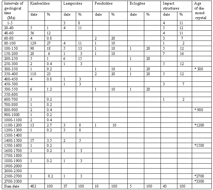 Most likely, it is connected with the decrease of the periods of tectono-magmatic activity on the processes of irregular reduction of the volume of decomposed hydridic core and increasing of the thickness of mantle during the pulsating-expanding evolution of the Earth. The reduction intervals of the geological tectonic cycles from the protoplanetary stage to nowadays, based on 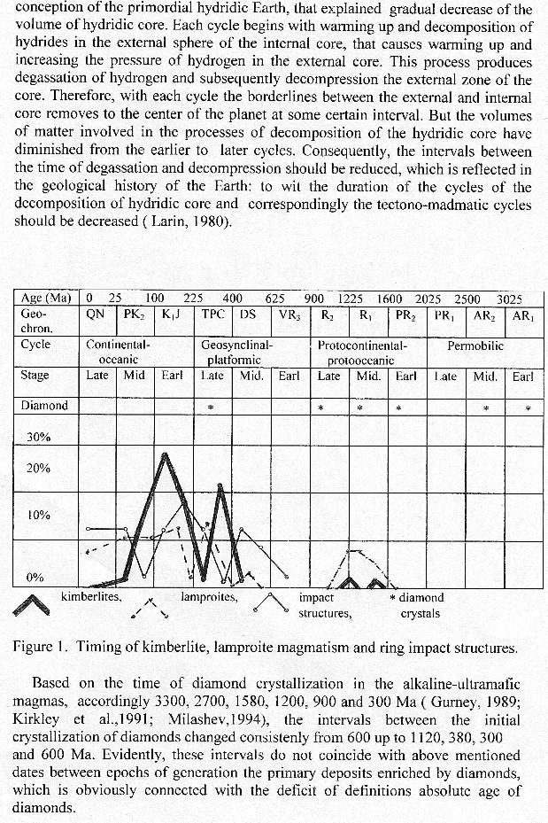
Many researchers affirm, that all diamonds in kimberlite and lamproite are xenocrysts and are formed in the garnet peridotites and eclogites in the upper mantle and then picked up by the kimberlite magma during their ascent to the Earth’s surface. Accordingly, there is no genetic connection between the time of the formation of diamonds and the kimberlites (Gurney,1989; Kirkney et al., 1991). However, the fact of the presence in kimberlites of pipe Premier (1200-1180 Ма) diamonds (1200 Ма) with the identical absolute age, testifies to the crystallization these diamonds from the same sources in the upper mantle, where this kimberlite magma is generated. Besides, if the kimberlite dikes, sills and pipes would be a simple elevators for lifting diamonds from the mantle sources to the surface, then it is reasonable to assume that in two coeval and adjacent kimberlite bodies the contents, morphology and grade of diamonds should be identical. However, in real nature, it has not been observed, behind a very rare exception. For example, in the kimberlite field Kimberley (Southern Africa) there are more then 95 bodies, five of which are the world famous diamond deposits of late Cretaceous age (95-84 Ма), there are pipes Kimberley, De Beers, Wesselton, Dutoitspan, and Bultfontein. All of them are situated side by side on the area of 8х8 km2, with intervals from 2 up to 4 km. But they have different chemical composition of kimberlites; various contents, habits and the quality of diamond crystals (Du Toit, 1957). All this testifies to the advantage of crystallization diamonds from the various sources at the evolution of kimberlite melts in each body. 2. DISTRIBUTION OF DIAMOND RESOURCES IN KIMBERLITES AND PLACERS The distribution of established resources of the diamonds, which are genetically connected to kimberlite and lamproite, represent practical and scientific interest. The deposits of these specified types enriched with diamonds are dated to the epochs of tectono-magmatic activity on the platforms in mddle Riphean (1450-1400 and 1200-1100 Ma), lateDevon (370-350 Ma), late Mesozoic`(113-84 Ma) and Cenozoic (60-20 Ma). The total recovery of diamonds from ancient to younger epochs from magmatic deposits and placers, make accordingly 23.5%, 19%, 54% and 3.5% (Table 2). The finds of the diamonds in late Archean and early Proterozoic conglomerates still have a mineralogical interest (Krutoyarskiy, et al., 2000). In order to observe the more objective picture of distributions diamonds in kimberlites and lamproites we had calculated the reserves of diamonds that leftover in discovered fields. The total amount of diamonds resources, including the crops and reserves that had been found in the bowels of the Earth to 2000 year from late Proterozoic, middle Paleozoic, Mesozoic and Cenozoic are accordingly 16%, 18%, 52% and 14% ( Cole et al.,1998; Erlich, Hausel, 2002; Krutoyarskiy et al.,2000; Milashev,1994; Miller,1993; Mineral Yearbook, 1993-2004 ) (Table 2,3,4). Table 2. Recovered reserves and resources of diamonds in the kimberlites, lamproites and placers of the Earth (in million carat - Mc) 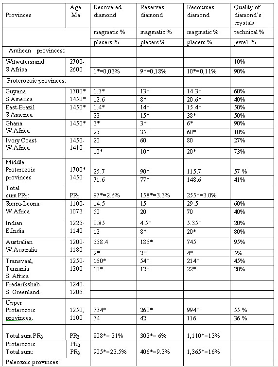 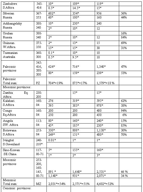 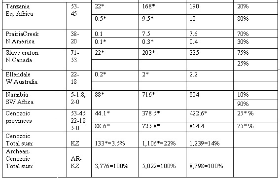 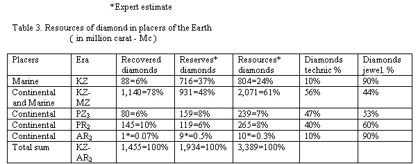 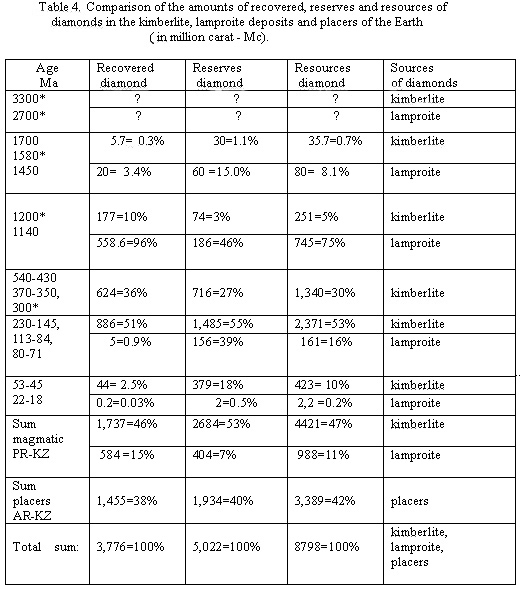
We have to sum up the resources of diamonds from Cenozoic placers with the Mesozoic dates, because basically, the primary sources of these diamonds, were the Cretaceous and Jurassic kimberlites, especially on the African continent and Sibirian, that total amount are no less than 60%. Thus, we come to the conclusion that the resources of diamonds in the bowels of the Earth were periodically increasing from ancient epochs to the present time. The majority of rich and middle diamond-bearing kimberlite provinces and deposits were opened on the subcontinent Gondwana, about 75% of them, especially in Southern and Equatorial Africa. On the platforms of the subcontinent Laurasia were detected mainly midlle and weakly diamond-bearing kimberlites pipes, sills and dikes, among them there are only 25% rich deposits. On the average of the Earth only about 2.5 % of the diamonds mines have been explored. The relative amount of exploited bodies reaches 10-14% in the central zones of diamond rich kimberlite provinces, whereas in the intermediate zones of diamond-pyrope subfacies are known only rare and weakly diamond-bearing kimberlites, in amount approximately 20% , and even mineralogical presence of diamonds is established on peripheries of the provinces. Thus, we come to the conclusion that the resources of diamonds in the bowels of the Earth were periodically increasing from ancient epochs to the present time. This conclusion has practical and scientific significance. In our opinion, one of the possible reasons of the increasing resources of diamonds in younger epochs of kimberlite magmatism in comparison with more ancient is the increasing thickness of depleted (pyroxene-olivine) pyrolite layer of the mantle (restite). From the pyrolite layer the lithophile elements are taken away, and the formation of kimberlite magma had originated in more deeper horizons of the non-depleted mantle, composed by garnet peridotite and pyroxenite (hypolite), where have been more favorable thermodynamic conditions for crystallization diamonds (Krutoyarskiy at al., 2000). 3. EPOCHS OF FORMATION DEPOSITS OF LITHOPHILIC ELEMENTS AND DIAMONDS The epochs of display the diamond-bearing kimberlites have coincided with the epochs of generation deposits of lithophilic elements, enriched by terra-rare elements and rare metal. All of they are situated on the cratogene platform structures of the Earth and have the age 2500, 1225, 625, 400, 225, 100 Ма (Figure 2, Table 5) (Krutoyarskiy et al., 2000). The extraction of rare metals and alkaline are proceeded by the deeply originated intertelluric fluids from the pyrolite layer of the depleted mantle. These fluids have periodical arisen by the degassing protonic hydrogen from the core of the Earth, which connected to the adequated stage of tectono-magmatic activity. The new stage of the formation terra-rare lithophilic elements in the same block of the earth's crust is possible only in connection with a new stage of expansion of the Earth and the appearance of new volumes of pyrolite, due to disintegration garnet peridotite layers of the non-depleted mantle (Larin, 1980). At the same time in the non-depleted mantle (hypolite) on depths of 170-250 km, arise the " hot points " above the jets of protonic hydrogen and partial melting of the garnet peridotite begins. As the result of this process within the upper mantle an alkaline-ultramafic magmas and displays of diamond-bearing kimberlites and lamproites are being formed. Table 5. Reserves and resources of lithophile terra-rare elements and diamonds 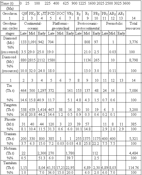 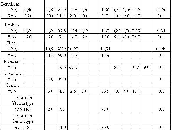
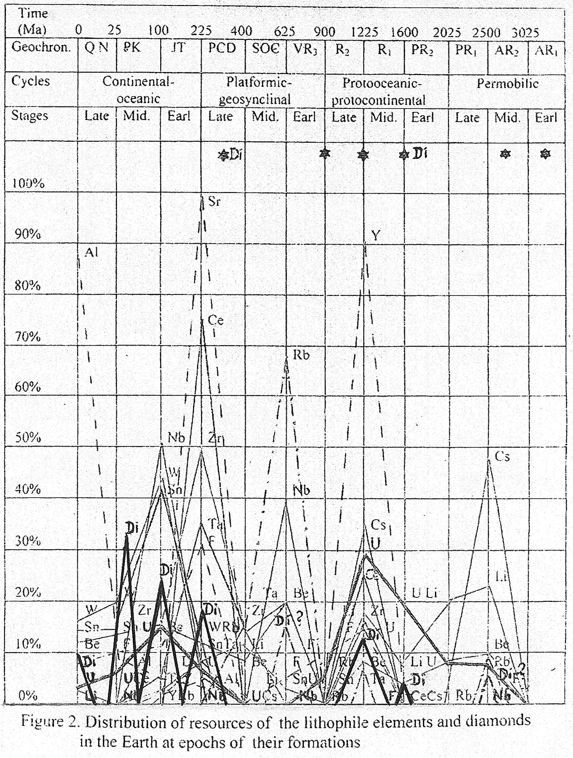
Меtallogenic epochs of formation deposits of lithophilic rare elements coincide in time and space to the periods of tectono-magmatic activity after long periods of tectonic rest on the platforms. The close geochemical connection of the terra-rare lithophilic elements and alkaline, especially potassium, testifies to the united depth of the source. In the opinion of V.N.Larin (1980), the juvenile sources of these elements are the olivine-pyroxene rocks of the depleted upper mantle. The extraction of lithophilic elements from pyrolite layer is carried out by deep intertelluric fluid, the appearance and character of which is determined by degassing of hydrogen from the external core of the Earth. The accumulation contents of terra-rare elements in the areas of tectono-magmatic activity is caused by increasing the thickness of pyrolite layer at upper mantle in connection with the expansion of the Earth, as well as the corresponding fall of gravity, reduction of gradient of pressure in mantle and transformation spinel-garnet peridotite to olivine-pyroxene rocks. It is accompanied by “lattice downthrown” of isomorphous impurity of lithophile elements and alkaline, especially potassium. At the appearance of intertelluric fluidic flow these elements are exposed by "flotation " and are involved in processes of formation rare metal ores in the upper parts of terrestrial crust. The sources of the potassium and water, that were necessary for generation alkaline-ultramafic melts in the upper mantle and formation K-richterite-olivine and leucite lamproites, you have to search not in processes of obduction ocean’s plates and convection, as major researchers assume (Gurney, 1989; Kirkley et al. 1991), but at the natural evolution of the pulsating-expanding Earth. Thus, at the consideration of evolution terrestrial crust and upper mantle of the continents on the basis of the hypothesis of the primordial hydridic Earth, allows us to come closer to the understanding the internal reasons of determining foundations of the distribution of lithophile rare elements and diamond-bearing kimberlites and lamproites in the time and space. 4. EPOCHS OF CRATONIZATION AND KIMBERLITE MAGMATISM As a rule, the diamond-bearing kimberlite provinces are located within the largest cratons on the platforms and shields with a powerful cover of sedimentary-volcanic and metamorphic rocks. This observation was first made by T.N. Clifford (1966) in Africa and is known as Clifford’s Rule. There are approximately 5,000 kimberlites, worldwide of which 500 are diamond-bearing, and almost exclusively occur on Achaean cratons. Diamond-bearing lamproites are located in Proterozoic mobile belts adjacent to Archean cratons (Janse and Sheahan, 1995). All well-known diamond enriched kimberlite and lamproite bodies are connected with epochs of the greatest cratonization of the Earth, comprising the interval from 1200 up to 100 Ма (Figure 3). At that time the subcontinents Pangea III and II were generated. Except for already known deposits, other diamond-enriched kimberlites with age 900 and 600 Ма, can possibly be discovered. The subcontinent Pangea I, which existed among 2700-1600 Ма, had a rather small amplitude of elevation, and probably because of it, rare and insignificant displays of diamonds are connected with kimberlite and lamproite magmatism. On the contrary, the protoplanetary cycle of the development of the Earth up to 3100 Ma was differed with its intensive tectonic movements and formation of numerous rather small cratons (Salop, 1982). Diamond-bearing garnet peridotites, eclogites and kimberlites could be dated to that cratons, for example, with age 3300 or 2700 Ma (Table 1, Figure 2, 3). The most general fundamental law of kimberlites dislocation is their presence only within the limits of ancient platforms. The kimberlite volcanism is infallibly related to the history of geological development of cratons. It is a product of evolution the upper mantle under the spacious platform areas. The largest displays of the ultrabasic and alkaline-ultrabasic volcanism on the planet are the kimberlite provinces, surrounded on their periphery with bordering zone of pikrites. The formation and localization of kimberlite provinces (diameter up to 2000 km), their diamond-bearing fields (diameter up to 50 km) and separate pipes of explosion (diameter up to 1.5 km) were caused by essentially various of type and scale of natural processes. So, occurrence of kimberlite provinces was one of consequences of evolution the upper mantle of the planet. The kimberlite fields were formed as a result of raising the alkaline-ultrabasic melts along zones with increased permeability of the earth's crust. The location of explosion pipes and dikes within the limit of kimberlite fields occurred in the superficies joints of the crossing ore-controlling and ore-accommodating dislocations. According to representations about relationship between the cause-consequence of kimberlite magmatism with convective currents in the upper mantle, in particular, with elevation of the Mohorovichic discontinuity and the subsequent subhorizontal diffluention of warmed up substratum, it was assumed that at the foot of earth's crust under every kimberlite provinces there arose a huge "lenses" of intermediate deep crust-mantle substances (Milashev, 1974; Greenson, 1984). Mobilization and radial movement of huge masses of heated substratum, possessing with high viscosity, inevitably resulted in the elevation of extensive areas of earth’s crust on the platforms and formation cratons. The elevated areas were exposed to denudation, the size and age of which is reliably established by geological methods. Predominantly the distribution of kimberlites over the areas with long, slow and steady elevation is the main regional law of dislocation kimberlites at the level of provinces. The kimberlite fields are dated to zones of touchy permeability on the areas, but with the lower thickness of earth’s crust (Мilashev and Rosengerg, 1974). Complex researching of rocks megacracks and based on it structural separation of kimberlites fields of the Siberian and Russian platforms has shown, that overpowering majority of kimberlite diatrems are located (96 %) within the limits of blocks with isotropic orientation megacracks, that allows to accept contours of these blocks as structural borders of kimberlites fields (Мilashev, 1981). Two basic types of kimberlite fields are differed at the orientation and interaction of dispositions, which internal structure is characterized by mesh or subparallel arrangement of kimberlite-localize dislocations. In the fields where the systems of dislocations refer to mesh type, kimberlite bodies localized in places of crossing supervising and locating dispositions, which are distributed without equability plan. On the contrary, in the fields with subparallel systems of dislocations the order of disposition diatrems and dikes are determinated by the presence of two-three similar orientated and convergent linear groups of kimberlites bodies pulled together in tracer space. The most perspective on diamonds are the kimberlite fields of diamonds subfacies with a mesh structure of systems dispositions, many stages of formations and much diversity of rocks composition. The absence of commercial deposits of diamonds in two kimberlite fields of Yakutian with subparallel systems of dislocations is, probably, caused by belonging these fields to subgroup of few stages and their localization in a zone of mutual development kimberlites of diamond and pyrope subfacies. Two basic types of kimberlites bodies - explosive and hypabyssal - are clearly defined. The explosive types of rocks are submitted by actually pipes of explosion, flattened-tubular bodies and inflations on dikes, consisted of kimberlites breccias. The hypabyssal types are represented by massive kimberlites fulfilled dikes, sills, lenses, injections in karstic cavities, and also "columns” inside the diatrems. Under the earths crust the pyrolite mantle (restite) reach up to depth of 200 km. In Cenozoic the non-depleted mantle (hypolite) reaches up to death of 300 km and is represented by garnet peridotite. According to the data by study mineral and gas inclusion in diamond crystals, at the depth ranging from 170 up to 240 km, there are the places of origin alkaline-ultramafic melts above the "hot points” at the pressure more than 4-7GPa. As a result of long differentiation of the initial melts or numerous "zoning melting"of the garnet peridotite came the formation of all gammas of alkaline-ultramafic rocks, starting from kimberlites, lamproites to picrites and carbonatites (Milashev,1994). The "hot points " in non-depleted mantle, most likely, have arisen above the jets of superheated protonic hydrogen, which rose from the top of liquid environment of the hydridic core, represented by metals with dissolved hydrogen (Larin, 1980). The decomposition of hydridic core of the Earth on metals and protonic hydrogen occurred, apparently, influenced by "pumping up” the galactic energy at the passage our planet together with the Sun through magnetic and radiating belts (zones) at the time of their rotation around the center of the Galaxy in current of the sidereal year, with the duration of approximately 212-225 Ма. It is necessary to note, that inside the same Kaapvaal-Zimbabwe craton in the Southern Africa the diamond-bearing kimberlite magmatism was reiterated for three times: in late Archean (2700-2600 Ма), in late Proterozoic (1200-1100 Ма) and in Mesozoic (200-80 Ма) with intervals of approximately 1500 and 1000 Ма. It testifies to the fact that the Southern Africa, since late Archean including up to Mesozoic, at all time stood above the same " hot area " in the upper mantle, which was the source of kimberlite magma in the various periods of tectono-magmatic activity. It is possible to explain that cratons and continents always remain rigidly connected with their roots in the upper mantle. The continents are disjointed along the deep riftogen zones, which were established in the mantle. The riftgen zones are served as ways of degassing protonic hydrogen while warming up and decomposing the hydridic core at the expansion of the Earth. Most likely, that repeated occurrence of diamond-bearing kimberlites within the same area in the upper mantle take place as the result of a long processes of transformation from hypolite to pyrolite. The new centers of kimberlite magmas arose at the greater depths in the non-depleted mantle (hypolite) from garnet peridotite, above the jets of protonic hydrogen during the new tectono-magmatic activity. Probably, at deeper levels in the non-depleted mantle the thermodynamic conditions were more favorable for crystallization diamonds from alkaline-ultramafic melts. Therefore, in the later epochs of tectono-magmatic activities in Southern Africa more diamond enriched kimberlites deposits of Mezozoic age were generated (Table 2), (Krutoyarskiy et al., 2000). In our opinion, each of the diamond-bearing kimberlite epoch within the limits of platforms finished by formation of the large ring impact structures, caused by brisant evolution of superheated hydrogen gases of huge capacity from hydridic earth’s core in places of crossing the deep faults. If in such places are available graphite gneisses or layers of carbonic schists, under influence of high temperatures (2000 Co) and extreme impact pressure graphite passes in hexagonal diamond – lonsdaleite. For example, in the Popigay ring impact structure 36 Ma (diameter about 100 km), which is located at the North Siberian platform, had been determined small diamond crystals (Masaitis et al., 1998). The conditions of genesis and location of impact diamonds are sharply differ from all known magmatic and metamorphic deposits of diamonds. The resources of diamonds, located in impact rocks of the Popigay ring structure, as a whole, exceed those in all known in the World diamond-bearing kimberlite provinces. The impact diamonds which have recovered from original impactites rocks (tagamites and suevites) have sizes from 0.05 to 2 mm across. Diamonds found at nearby placers seldom have grains up to 8 - 10 mm in diameter. Most diamonds are shades of yellow and some are colorless, gray and black. The impact diamonds are usually represented by polycrystalline aggregates of cubic and hexagonal modification (lonsdaleite) of carbon. They often form paramorphs with graphitic crystals. Lonsdaleite in impactites forms small elongated or irregular grains in fine-grained aggregates with graphite and diamond, or with diamond only. It can also form a type of matrix in relation to small cubic or cubic-octahedral diamond crystals. The lonsdaleite can form as much as 60 % of fine-grained aggregates. In contrast, the chaoite is rarely found in the graphitic and diamond-lonsdaleite aggregates of the Popigay impactites. It reflects the fact that the temperature of impactogenesis exceeded 2,000 Co (Masaitis et al. 1998). However, the quality of impact diamonds is very low, because of the small size of crystals and friable texture of joints, which makes them suitable only for the abrasive industry. At the crushing and abrasion of impact rocks the loss of diamonds reaches more than 25%. There are two opposite models of the genesis of ring impact structures. Some researchers consider that they were formed due to external space forces by falling and impacts of super large meteorites or astroblemes on the surface of the Earth (Masaitis et al. 1998); others - due to internal terrestrial forces at brisant explosions of mantle gases of huge capacity in the places of crossing abyssal breaks (Polyakov and Truchalev, 1980; Marakushev, 1995). A.A.Marakushev (1995) suggests that the so-called astroblemes or ring-impact-structures are generated by the brisant explosions of hydrogen-rich gases, which are rising from the earth’s core. The diamonds were formed in the impact melts owing to a reactions of Cr, Ni, Fe and others metals (M) in the form of metal-organic combinations: M (CN)2 and M CN2 ; M (CH) 2 and MCH2. There are determine, that the gas inclusions in the glass rocks of Popigay structure are contain in unique amounts of H2 (up to 20 %) and CH4 (8-22 %). The presence of hydrogen and methane is interpreted by rapid uplift of hydrogen-rich and methane fluids from the earth’s core, where the juvenile gases are held at the greatest pressure. 5. NATURAL SOURCES OF DIAMONDS IN THE EARTH Kimberlites and lamproites are the main and principal natural sources of commercial diamonds on the Earth. They make a significant quota in gross crop of diamonds, and also are an unique source of jewelry and high-grade technical stones. The finds of diamonds in others magmatites, impactites, metamorphic and fluiogenic rocks definitely represent the scientific interest, but have no practical value (Table 6). The primary ultrabasic and alkaline-ultramafic melts that generated the diamond-bearing kimberlites and lamproites appeared in the non-depleted upper mantle at the thermodynamic condition appropriate to the stable crystallization of diamond and pyrope. Then, during the periods of tectono-magmatic activity, these melts rather quickly reached to the superficial terrestrial horizons, where the preservation of barophilic minerals and diamonds in kimberlites and lamproites had emanated. V.A.Milashev (1963) has offered to parcel out under the name “kimberlite facies” of magmatism, which the crucial minerals are barophilic diamond, pyrope and titanium magnochromite. The rocks of similar chemical and mineralogical composition, however, without diamond and its barophilic minerals - satellites, concerning to low bariphilic “pikrite facies”, have to kept the habitual petrographic names. Increasing the alkaline higher than the limits in the phlogopite kimberlites at the common basicity of alkaline-ultramafic melts resulted to appearance in these rocks at first K-richterite and then leucite. For difference the usual “olivine kimberlite” I type and “phlogopite-olivine kimberlite” II type from potassium enriched lamprophyres (lamproites), which are some of variety rocks of kimberlite facies V.A.Milashev (1994) has offered the name "K-richterite-olivine kimberlite” III type and “K-richterite-leucite kimberlite” IV type. The borderline between the four listed basic types of kimberlites carry a statistical property and correspond approximately between olivine and phlogopite-olivine kimberlites - 1 % К 2О, then among phlogopite-olivine and K-richterite-olivine kimberlites (lamproites) - 3,3 % К 2О, and between K-richterite-leucite kimbrlites (lamproites) - 7 % К 2О ( Table 7). Table 6.Classification of the natural sources of diamonds. (Milashev,1994). 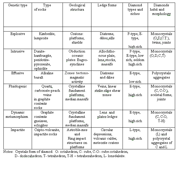 Table 7. Principles of petrology classification of kimberlite, picrite and lamproite (Milashev, 1994) 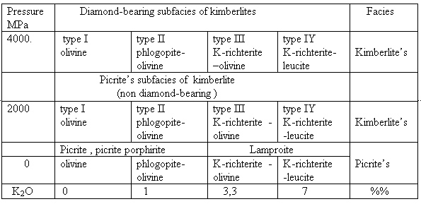 The diagram εNb – ε Sr shows the genetic relation between kimberlites, enriched of potassium volcanic rocks and mantle nodules, K-richterite phlogopite lamproites, garnet phlogopite and garnet peridotite xenolithes from the province Kimberley in Western Australia ( Figure 4) (Hawkeswoath at al.,1985). 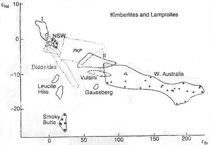 Figure 4. The diagrame εNb – ε Sr shows the variations of potassium in kimberlites, volcanic rocks and mantle xenoliths. PKP (phlogopite K-richterite), GPP (garnet-phlogopite) and GP ( garnet ) are whole-rock peridotite xenolithe from the Kimberley area. The Group II kimberlite are mostly from Finsch mine, South Africa, and the Group I kimberlite are of South African Cretaceous kimberlites ( Hawkesworth, Fraser and Rogers, 1985). Reprinted with permission of Geological Society of South Africa. It is necessary to note that the Australian geologists, who opened the first diamond-bearing olivine lamproite pipe Argyle in 1979 in West Australia, had suggested, that there was a genetic relation between lamproites and diamond-bearing kimberlites (Jagues et al.1982; Atkinson et al. 1984). 6. ZONING OF DISTRIBUTION DIAMONDIFEROUS KIMBERLITES The analysis of geotectonic conditions shows, that kimberlite magmatism was appeared only within the platforms. The epochs of kimberlite volcanism are connected to the certain stages of tectono-magmatic activity of cratons. The beginning of kimberlite volcanism is dated to the finishing stages of long and steady uplift of platforms. All evidences testify to the spatial distribution of different facies of rocks within the limits of kimberlite provinces to their concentric zonal structure. As a rule, in the center of provinces there are kimberlite or lamproite fields of diamond subfacies, where all bodies are diamond-bearing, however, only 8–10% from them have industrially profitable. In the transitive zone there are kimberlites of diamond-pyrope subfacies, where only 20% of bodies are weakly diamond-bearing and rarely profit to work. On the periphery of the provinces there are fields of pyrope subfacies without diamonds, which are frequently accompanied by picrite and carbonatite. It also meets incomplete zonal kimberlite provinces (Figure 5,6,7), (Krutoyarskiy, Milashev, 1964; Milashev, 1965; 1994). 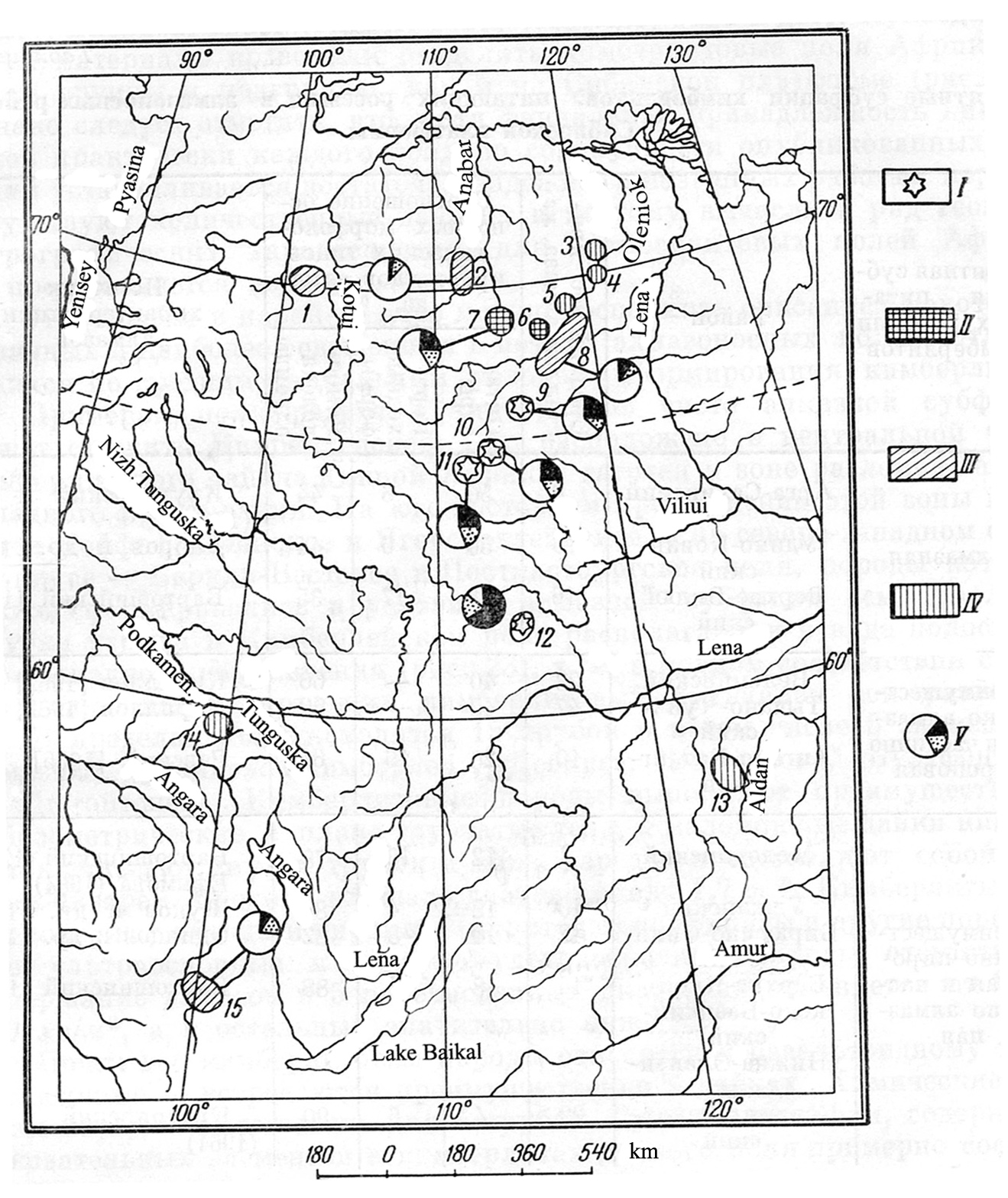 Figure 5. Facies of kimberlites and morphology of the diamond’s crystals relatedtokimberlites on the Siberian platform. Reprinted with the permission of the Publishing House “Nedra”. The fields of kimberlites subfacies: I – diamond’s, II – predominantly diamond’s and partly pyrope’s, III – predominantly pyrope’s and partly diamond’s, IV – pyrope’s. V – ratio of diamond crystals (%%): octahedral (black), dodecahedral (white) and transitive forms (shadow). Names of the kimberlite fields: 1 – Kotiy-Maimecha, 2 – Kuonamka, 3 - Kuoika-Beenchime , 4 - Merchimden, 5 Lower-Ukukit, 6 – Omonos-Kutugun, 7 – Luchakan, 8 – Ogonor-Chomurdach, 9 – Upper-Muna, 10 – Daldyn, 11 – Marcha-Alakit, 12 – Little-Botuoby, 13 – Upper-Aldan, 14 – Chadobets, 15 – Oka. The morphology of diamond crystals in the kimberlites bodies and fields testifies about various thermodynamic (facies) conditions of the formation of diamond deposits, their safety, rating and value. Flat face crystals of diamond,as a rule, prevail in kimberlite fields of diamond subfacies. They are represented by octahedrons, dodecahedrons and transitional forms, less often by cubic and tetrahedron habit. In kimberlite fields of diamond-pyrope subfacies, the curve face crystals of diamond prevail over the flat face, which proves the significant dissolution of diamond crystals at the slower rise kimberlite magma to the surface of the Earth (Table 8, Figure 5) (Krutoyarskiy, Milashev, 1964). Table 8. Subfacies of kimberlites and morphology of the diamonds on Siberian platform (Krutoyarskiy, Milashev, 1964) 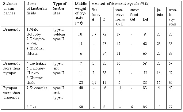 Note: Crystal’s form of diamond: H- hexahedron, O – octahedron, O-D – octahedron-dodecahedron, Od – octahedroid, Dd – dodecahedroid. 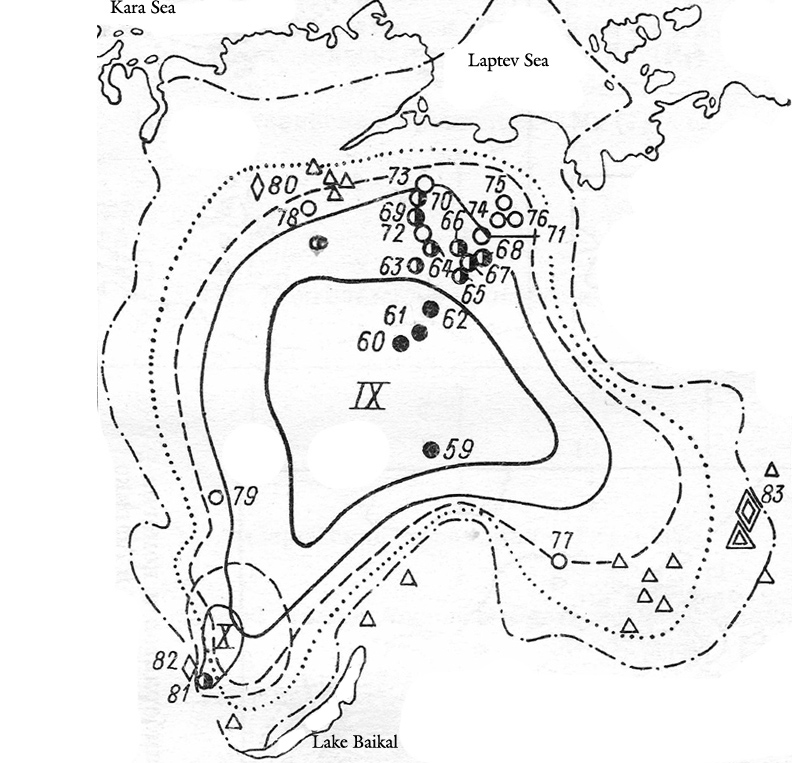 Figur 6. Regional schema of distribution facies of kimberlites and comagmatic rocks on Siberian platform. See the legend on figure 7. Reprinted with the permission of the Publishing House “Nedra”. 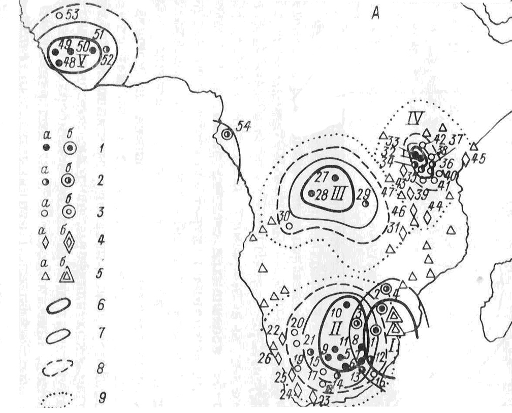 Figure 7. Regional schema of the distribution facies of kimberlites and comagmatic to them alkaline-ultrabasic rocks and carbonatites in Africa. Reprinted with the permission of the Publishing House “Nedra”. The fields of kimberlites subfacies: 1 – diamond’s ( a – Phanerozoic age, b – Proterozoic age); 2 – diamond’s and pyrope’s (a – Phanerozoic age, b - Proterozoic age ); 3 – pyrope’s (a – Phanerozoic age, b – Proterozoic age ); 4 - fields of pikrites and pikrite porphyrites ( a – Phanerozoic age, b – Proterozoic age); 5 – fields of alkaline-ultrabasic rocks and carbonatites ( a – Phanerozoic age, b – Proterozoic age ). The borders of distribution: 6 – kimberlite diamond’s subfacies, 7 – kimberlite diamond-pyrope’s subfacies, 8 – kimberlite pyrope’s subfacies, 9 – ultrabasic and alkaline-ultrabasic porphyres rocks of pikrites subfacies. Kimberlites provinces: I – Transvaal (PR3), II – Kalahari (MZ), III – Congolese (MZ), IV – Tanzania (MZ), V – Liberia (PR3, PZ2, MZ), VI – Gabon (PR3). 7. PHISICO - CHEMICAL CONDITIONS OF CRYSTALLIZATION DIAMONDS  It appears that the main process in the evolution of kimberlite magma is a layer magmatic differentiation. At different stages of layering the melt takes a chemical liquation and the magma is separated into two immiscible melts. Accumulation of heavy crystals in the bottom parts of the melts and squeezing will separate a portion of magmatic liquid from the earlier crystallized layer. Deep in the upper mantle, the magmatic differentiation into two squeezing of melts had passed with the different silica contents, that resulted in lower peridotite and in upper eclogite layers. It is assumpt that within the upper mantle there is a bimodal segregation of the rock-forming elements into two magmas: a relatively reduced by ultramafic components with higher hydrogen content; and a relatively enriched by oxidized components with lower water content. This difference in deep-seated magma chambers provides contrasting environments for the formation a different types of diamond (Marakushev et al., 1995). The differentiation of the rock-forming elements in the initial ultramafic melts is accompanied by contrasting distribution of the fluid components, that results in formation two different types of diamond crystals – eclogitic and peridotitic (Figure 8,9). The next stage of magma layering probably occurs at plutonic stage. The primary process at this stage is the separation of ilmenite rich magma from the silicate melt. The third and final step of magmatic evolution occurs during the hypabyssal stage. At this stage, after the separation of heavy mineral, the melts enriched by carbonate, is squeezed and apparently it is resulting in generation two types of magmas: kimberlite and carbonatite (Marakushev et al., 1995). 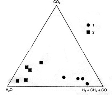 Figure 8. Compositions of fluids typical to eclogitic (1) and peridotitic (2) diamonds ( Marakushev et al., 1995). Reprinted with the permission of the Doklady Russian Academy of Science. 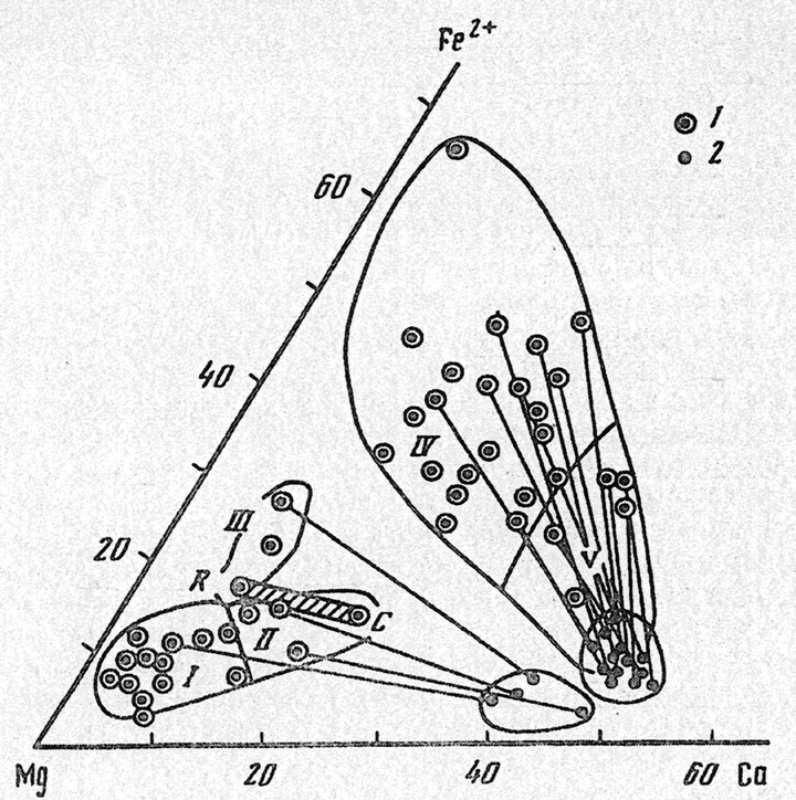 Figure 9. Types of diamond recognized at garnet and clinopyroxene inclusions, which characterize composition of original rocks: I – dunite-harzburgite, II – lherzolite-wehrlite, III – pegmatite ( recognized by garnets from megacrysts ), IV – clinopyroxene-eglogites, V – kyanite-eclogites. Shaden band – changing of composition within zonal garnet from the core (C) toward the rim (R), which characterizes the transition from peridotites to enstatite pegmatites. Legend: 1 –garnet, 2 – clinopyroxene ( Marakushev et al., 1995). Reprinted with permission of A.A.Marakushev. 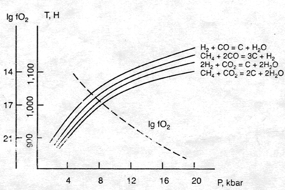 Figure 10. The increasing O2 activity with the decrease of pressure and approximate parameters of diamond formation within the system C-H-O-S (Portnov, 1982). Reprinted with the permission of Doklady of the Russian Academy of Sciences. Probably the most important change in physico-chemical conditions in the ascending kimberlite column is related to self-oxidation of volatile “bubble”. It is commonly accepted that kimberlite magmas are being initiated by the process of fluid diapirism. This fluid is chiefly composed of hydrogen methane that was accumulated in the mantle under the platform plates. During the ascent of the magmatic column, if the pressure of magmatic system drops below 20 kbar, the oxygen fugacity will increase, that resulting in the oxidation of the fluid to CO, CO2 and H2O (Figure10; Portnov, 1982). However, the rapid movement of the magma at the pressure lower than 20 kbar may preserve diamonds. Near the surface, water is absorbed by the kimberlite magma at the serpentinization. Due to hydrogen and methane oxidation, the initial volume of the kimberlite rocks may vastly decrease. 8. PETROCHEMISTRY OF KIMBERLITES AND FACTORS OF DIAMONDIFEROUS It is necessary to note the importance of establishing the dependence of grade diamond-bearing from the chemical composition of kimberlites and paragenic minerals of the megacrysts and nodules. For example, some specific kimberlite minerals with favorable geochemistry (high-Cr, low-Ca pyropes and picroilmenite ) can be used as direct indicators of the presence diamond. To the same lines concerns the idea of correlating the chemical composition of the kimberlite to the diamond content. 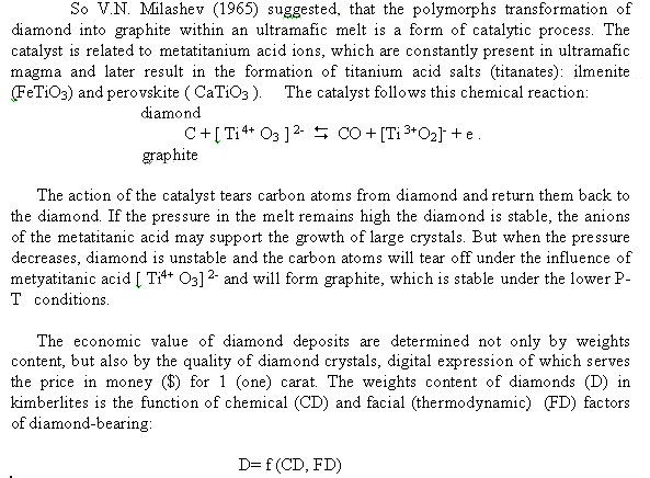 V.A.Milashev (1965) determined the formula for calculating the coefficient potential of diamond-bearing kimberlites (CPD), that allows on the date of chemical analysis define the rate of favorable alkaline-ultramafic magmas for diamond crystallization. The chemical composition of various kimberlites was compared to the sampling results of different pipes for diamond content and the chemistry showed a correlation with diamond content. The dependence between these two parameters was noted and it can be calculated using the content of Ti, Fe, Al and K. The data permits one to determine the degree of a melt’s favorability for diamond’s crystallization and consequent preservation of diamond crystals. 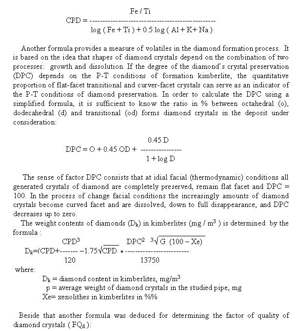 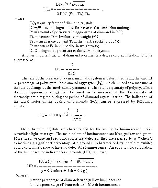 g = the percentage of diamonds with greenish luminescence others = the percentage of diamonds with “others” colors of luminescence By using the data from 37 kimberlite pipes from Yakutian the dependence between LID and CPD has been established with a positive correlation coefficient of + 0,66 - +0.09. It is suggested that the diamond potential of a lode source (CPD) can be assessed using the luminescence of diamonds (LID) obtained from panned samples and placers. The research of the factors of diamond-bearing kimberlites has opened the opportunity to assess diamond-bearings without taking huge-volume probes, but rather using several chemical analyses of kimberlites and the data of diamonds morphology from the near river placers to calculate the upper limit of the weight contents of diamonds in this body. By multiplying the resulting meaning on the price for 1 carat one can receive the forecasted cost of diamonds in 1 m3 of that kimberlite body. The information on the pipes' size in the cross-section allows to calculate its probable volume and then to forecast estimation of total reserves and cost of diamonds in that kimberlite pipe. These calculations have been done and found the verification on the elaborated kimberlite pipes and fields of the Yakutian province (M.A.Krutoyarskiy, 1968; Milashev, 1984). 9. FACIAL CONDITIONS OF SAFETY DIAMOND CRYSTALS IN ULTRAMAFIC ROCKS AND KIMBERLITES Diamond crystals are exceptionally stable mineral under a various thermodynamic conditions, because the temperature of melting of diamonds reaches 3570 oC at the absence of oxygen. The diamond starts transforming in graphite at the pressure 4.8-3.3 GPa and temperature less 1300 – 900 oC also at the absence of oxygen (Figure 11). Therefore, the crystals of diamond are preserved at considerable rate without free oxygen, if the original ultramafic or kimberlite melt are comparatively rapidly elevated to the terrestrial surface. However, under slow lifting conditions diamond-bearing magmas from the upper mantle to the terrestrial surface there is a gradual decrease the temperature of melts and at the presence of free oxygen the diamond crystals begin oxidize and turn into curved facet forms. Right of way there happened holocaust (“dissolution”) of diamond crystals in kimberlites of diamond-pyrope subfacies ( Fersman, 1955; Orlov, 1963; Krutoyarskiy, Milashev, 1964 ). If a diamond-bearing ultramafic melts slow rise to a terrestriasl surface in environment without oxygen the diamond crystals transform in graphite right-of-way to total paramorphose graphite upon diamond.  Figure 11. Thermodynamic conditions of formation the ophiolitic series of ultramafic rocks. 1,2,3 – massifs of Koryak highland, NE Russia; 4. massifs of New Zealand; 5.Adamsfield massif, Tasmania; 6. massifs of California; 7. the evolutionary trends of massifs denoted as (I) - the first ( New Zeland (NZ), California (CA), and (II) - the second (Koyak (KR), (Kaminsky, 1984). Reprinted with the permission of the Publishing House “Nedra”. The exclusive interest represents the Beni Bousera peridotite massif in NW Morocco, where mantle obduction slab, composed of altered spinel lherzolite accompanied by rare harzburgites and dunite pods. The four porphyroclastic eclogite layers within the massif are consisted by orange pyrope-almandine garnet and omphacite-pyroxene. The former diamond-bearing zones at Beni Bousera occur within garnet clinopyroxenites. Graphite paramorph of diamonds were identified in the garnet clinopyroxenite (Pearson et al. 1989). The graphite octahedrons are confined to four garnet clinopyroxenite composed magmatic cumulate layers in the lower portion of the ophiolite. Two of the layers are more than 2 m thick. They consist of orange pyrope-almandine garnet with compositions comparable to those found in diamond-bearing eclogites nodules and omphacitic pyroxene porphiroclasts including minor addition of plagioclase, spinel and sulfides. Along with wehrlites, lherzolites and diopsidites the graphite paramorph layers form an intercalated horizon up to 16 m thick at the apex of the massif. Graphite paramorphoses after diamond E-type in Beni Bousera massif form from 2-5% up to 15 % by volume of the layers. The size of this graphite paramorph after diamond octahedron and joints vary from 0.5 to 7 mm ( Figure 12).  Figure 12. The morphology of graphite paramorph upon diamond’s crystals from garnet pyroxenite of massive Beni Bousera (Slodkevich, 1982). Reprinted with the permission of the Publishing House “Nedra”. The X-ray diffraction upon these graphite paramorph of natural diamond shows, that it take place at the 4.8 to 10 GPa pressure and high temperature without access of oxygen at the processes of the metamorphism in 21.5 Ma years ago. Although the primary diamond was not preserved in the Beni Bousera obduction slab, the concentratoin of the graphitized diamonds indicates that the massif initially contained about 15 % diamond or approximately in 10,000 times as many diamonds per unit mass of rock as any know high-grade kimberlite. This grade is compatible with the diamond content of some of the small diamond-bearing eclogite xenoliths found in kimberlites pipes (Pearson et al., 1989 ). Thus, the content and quality of diamond crystals are connected by legible mathematical dependence to the chemical composition and the facial (thermodynamic) regime of formation and genesis the ultramafic rocks and related to them kimberlites. This dependence is an indisputable proof of their genetical connection and specifies simultaneously on the composition of environment, the mechanism and processes of formation diamonds. It is necessary to take into account by mining and choice the most proved models of crystallization diamonds in the ultramafic rocks and kimberlites (Milashev, 1994). Considering all of the above written, it is necessary to note, that the kimberlites enriched with diamonds can’t be simple transporters of diamonds from mantle ultramafic sources, but they are the genetic derivations of these primary sources. As any rich deposit of minerals, the diamond-bearing kimberlites are formed at the combination of the complex of favorable factors, which should be revealed and taken into account at forecast and searches a new diamond-bearing kimberlite provinces, fields and deposits (Krutoyarskiy et al. 2000). 10. MODEL OF FORMATION DIAMONDIFEROUS KIMBERLITES OF THE EARTH 1. At the passage of our Solar system through the magnetic and radioactive belts of the Galaxy during the sidereal years (225-215 Ма) there was taken periodic transfer of space energy to the Earth core. The results of these processes were a warming up and melting of the external sphere Е of the core (thickness about 2000 km) and the periodical pulsating-expanding growth of the Earth volume (Krutoyarskiy at al. 2000). According to the primordial hydridic hypothesis of the Earth, it was taking place the decomposition of hydrides in the core on metals Fe, Mg, Si and others with dissolved protonic hydrogen H+1 in them ( Vernadsky, 1960; Larin, 1980). 2. On the basis of studying deep intratelluric mineralization, which were forming inclusions in diamonds, it was established the places of diamond-bearing magmatic centers in the upper mantle on depths about 240-170 km. At these depths in ascending from decomposed hidridic core of the streams of hydrogen fluids there were generated of methane, water, carbon oxide and carbon components in amounts, sufficient for partly melting of the mantle substances. All these volatile components alongside with initial hydrogen are containing in the fluid inclusions of diamond and its paragenetic mineral sputniks. 3. Superheated volatile components was ascending through the mantle to the Earth surface at first by disorderly jets, and then gathered in streams in more top horizons, which in all probability formed “the hot spots and points " in the upper mantle on the depths of 240-170 km. The centers of partly melting mantle substratum have arisen in these “hot places” under the influence of superheated volatile, especially hydrogen and hydrocarbon. Then these initial magmatic melts were undergone to the processes of differentiation on the eclogite (top), pyroxenite (average) and peridotite (bottom) magmatic layers. Under the high thermodynamic conditions from volatile components (Н2, C, СН4, СО2, CO, Н2О) the crystallization of diamonds was derived, corresponding to the specified three types of melts: diamond Е-type from eclogites, diamonds Рх-type from pyroxenites and diamonds Р-type from peridotites (Figura 9) (Marakushev et al., 1995) . 4. Diamond and its barophilic mineral - satellites in the listed rocks concern to intratelluric mineralizations, arising in these centers before the introduction of diamond-bearing magmas to more high levels in earth's crust, where they were finally consolidated to forming diamond-bearihg initial intrusives. Basing on the definitions of radiometric age of inclusion minerals in diamonds, the following epochs of generation diamonds in non-depleted mantle (gipolite) we can emphasize: 3300, 2700, 1600, 1200, 900 and 300 Ма ago. 5. The processes of formation diamondiferous ultrabasic and alkaline-ultramafic rocks in the upper mantle are characterized by the long periods of maturation from 600-300 up to 1500-1000 Ma. During these periods there were heating, melting, magmatic differentiation and crystallization of diamond and its barophilic mineral - satellites in the intratelluric stage. Simultaneously, or somewhat later, there occured the transformation of non-depleted garnet peridotite in the upper mantle (gipolite) in depleted pyroxene-olivine mantle (pyrolite), enriched by lithophile and terra-rare elements. But the thickness of new pyrolite upper mantle is sharply increased because of increasing the volume of pyroxene-olivine rocks at such transformation. All it causes the uplift the surface of Mohorovichic discontinuity under continents and the swelling of earth’s crust with the formation cratons on the platforms. 6. The intrusives of diamondiferous peridotites, pyroxenites and eclogites, which have intruded into the bottom of platforms, represented the substrata for generation of the centers of secondary fluidalic kimberlite and lamproite magmas, developing by their replacement with an inherited diamond mineralization (the plutonic stage). These secondary, but related diamondiferous magmas, by the process of zonic melting, periodically derived from the upper mantle up to the bottom of earth’s crust (the hypabyssal stage). Along the deep faults and cracks in the earth crust kimberlite and lamproite magmas, eventually, reached the surface of the Earth, where they were preserved in the forms of the diamondiferous dikes, sills and explosive pipes (the explosive stage). 7. The generation of deep diamondiferous centers in the upper mantle, considering the absolute age of mineral inclusions in diamonds, occurred in Pre-Cambrian time, whereas the impulses of kimberlite and lamproite volcanism periodically renewed during an enormous geological time. These processes sometimes combined on the same territory, for example, in South-African and West-Australian cratons. Judging by the absolute age of mineral inclusions in diamonds and nodules of garnet peridotites, pyroxenites and eclogites in diamondiferous kimberlites and the time of kimberlite intrusions, the following epochs of kimberlite generation can be suggested: 3300, 2700, 2000, 1600,1000, 1200, 900, 600, 400-350, 380-340, 250-200, 160-140,110-90,70-50, 40-20 (Ma) (Table 1, Figure 1). 8. The formation of every separate kimberlite or lamproite pipe of explosion also occurred at some stages of repeated intrusion and explosion, that was accompanied by disintegration of rocks and minerals of the previous stages. For example, in kimberlite pipe Udachnaya (Siberian, Yakutian), which time of intrusion is defined as late Devonian (367-353 Ма), nodules of garnet peridotites, pyroxenites, eclogites and mineral inclusions in diamonds are found with absolute age: 3300, 2700, 2000, 1580, 1200, 650, 420, 370 Ма. 9. Kimberlite and lamproite are naturally entered in the general system of development of alkaline-ultramafic magmatism on platforms, representing facies of extremely high fluid pressure with its increasing alkaline magmatism gets more and more alkaline ultrabasic character. On the diagram εNb – ε Sr (Figure 7) we can see the gradual transitions from olivine kimberlite I type to olivine-phlogopite kimberlite II type, further to K-richterite-olivine lamproite (kimberlite III type) and, at last, to K-richterite-leucite lamproite (kimberlite IV type) (Milashev, 1994). 10. In the fluid pegmatite stage of development of kimberlite magmatism, selected by A.A.Marakushev (1995), the collective over-crystallization emanated from some fine diamonds to huge rare megacrystals of non-nitrogen diamonds of cubic habit and high quality, cleared from intratelluric mineral inclusions. The recordsman of size on the world are the famous diamond "Cullinan", which was found in kimberlite pipe Premier in Southern Africa and weighted 3,106 carats. 11. The most significant condition of preserving the degree of diamondiferous of the initial magmatic sources, except for the favorable chemical compound of alkaline-ultramafic magmas and thermodynamic conditions of diamond crystallization, is the speed of transportation diamondiferous kimberlites and lamproites from the upper mantle to the earth crust and, at last, to the surface of the Earth, where the diamond deposits were preserved. It is necessary to note, that the mantle diamonds are very stable against temperature influence, because the melting of diamond occurs at high temperature about 3570oC without any access of oxygen. The phase transition of diamond to graphite also happens without any access of oxygen, when the pressure in melts falls below 4.7-3,3 GPa (Figure 11). But in the presence of oxygen, crystals of diamond burn down at 1000oC, thus curved facet crystals of diamond are formed, and the weight of them decreases up to their full disappearance. 12. As a result of various speed and time of the elevation kimberlite magma to the surface of cratons and the vector’s extent of the uplift pathway from initial mantle sources of diamond in the limit of kimberlite provinces the zones with deposits of various degree of diamondiferous was formed. These zones are differed by average of weight, morphology and grade of value of the diamond crystals. Thus, in kimberlite provinces of Siberian and Africa the central zones are marked by diamond subfacies, then the intermediate zones – of diamond-pyrope subfacies and peripheral zones only by pyrope subfacies (Table 8, Figure 5,6,7) (Krutoyarskiy and Milashev, 1964; Milashev, 1974) 13. The high quality crystals of diamond are kept in diamondiferous kimberlites I and II types, in which flat facet of rather fine technical crystals prevail, with a significant quota of large jewel stones. There are worse quality of diamonds in lamproites (kimberlite III and IV types), where many fine technical crystals (up to 95 %) prevail and a few jewel stones. The high quality of diamonds is mainly dated to low degree diamondiferous kimberlites of diamond-pyrope subfacies, where large curve facet crystals prevail and a lot of jewel (70-80 %). The latter ones are genetically connected with the ancient late Proterozoic kimberlites, which usually settle on the periphery of cratons. 14. The next major condition of safety of the diamondiferous initial sources is the degree of the subsequent metamorphic and metasomatic changes of these rocks. As a vivid example can serve the graphitization of the initial octahedron crystals of diamond in Beni Bousera peridotite massif located in NW Morocco, that was obducted in Cretaceous period. That massif has undergone metamorphic transformation and graphitization in Miocene (21.5 Ма), therefore diamonds were completely destroyed (Figure 11.), (Pearson et al., 1993). 15. It was made the calculation of the recovered diamonds from kimberlite and lamproite deposits at the time of their formation, as well as the reserves of the diamonds, that were leftover in the bowels of the Earth. As a result it shows that out of 5 established diamond-bearing kimberlite epochs the most favorable were: late Proterozoic (16%), late Paleozoic (18 %), early Mezozoic (22), late Mesozoic (30%) and Cenozoic (14%) (Table 5, Figure 2). The resourses of diamonds in lamproites prevail above kimberlites only among late Proterozoic and middle Riphean deposits. In our opinion, the general increasing resources of diamonds in more younger epochs of kimberlite magmatism, is caused by the increasing the depth of occurrence of initial mantle sources of diamond in connection with growth of sickness of the depleted pyrolite upper mantle, consisted from pyroxene-olivine rocks (Krutoyarskiy at al., 2000). 16. Especially, it is necessary to emphasize the interrelation between favorable epochs of formation lithophilic terra-rare elements and diamonds, which settle within the limits of cratons, accordingly with the ages 2500, 1200, 600, 400, 220 and 100 Ма (Table 5, Figure 3.) (Krutoyarskiy et al., 2000). The lithophilic rare elements and alkaline was extracted from non-depleted hypolite layer of the upper mantle composed by garnet peridotite, pyroxenite and eclogite and its transformation in depleted pyrolite layer of the upper mantle, consisted from pyroxene-olivine rocks. They are carried out by abyssal intratelluric fluid which appearance is determined by the degassing of protonic hydrogen from hydridic core during the expansion of the Earth. At the same time in the non-depleted upper mantle at the depths of 240-170 km some " hot points " started up above the jets of superheat protonic hydrogen and partial melting of garnet peridotites layers began. The result of this was generation of alkaline-ultramafic magmas and than the displays of diamondiferous kimberlites and lamproites under the platforms. 17. In our opinion, each diamondiferous kimberlite epoch within the limits of platforms is finished by the formation of large ring impact structures, caused by brisant exhalation of superheated hydrogen gases of huge capacity from the hydridic earth’s core in places of crossing deep faults. If in such places the graphite gneisses or layers of carbonic schists are available, under influence of high temperatures (2000o C) and extreme impact pressure graphite passes in hexagonal diamond – lonsdaleite. For example, into the Popigay ring impact structure (diameter about 100 km) on the North Siberian platform was detected specific fine diamonds. They represent by polycrystalline aggregates of cubic and hexagonal modification (lonsdaleite) of carbon (Masaitis et al., 1998 ). The conditions of genesis and location of impact diamonds sharply differ from all known magmatic and metamorphic deposits of diamonds. The resources of diamonds, located in the impact rocks of the Popigay ring structure, as a whole, exceed those in all known in the World diamondiferous kimberlite provinces. However, the quality of impact diamonds is very low, because of small size of crystals and friable texture of joints, that’s why they are suitable only for the abrasive industry. 18. If take into account the time of the start intrusion of the diamondiferous kimberlites in the Yakutian province (376-353 Ма) and the age of the finishing non-diamond kimberlites and picrites of the pipe Obnagennaya (100 Ма), the duration of kimberlite magmatism will be approximately 276-253 Ма. However, if the time of formation Popigay impact diamonds (36 Ма) is taken into account to, the total duration of Yakutian diamond-bearing province will be 340-317 Ма or about 330 Ма. In our opinion, the general cause of the diamondiferous on this territory was the start and the end of exhalation the superheated protonic hydrogen gas from the hydridic core of the Earth, which has caused the global activity of tectono-magmatic processes into East-Siberian craton. 19. The content and the quality of diamonds are connected with precise mathematic dependence to the chemical compound and thermodynamic regime of formation kimberlites (Milashev, 1965). This dependence is the indisputable proof of their genetic connection with the structure of environment, the mechanism and processes of formation diamonds from the mantle primary ultramafic sources, with mechanisms and processes of transformation diamond crystals in kimberlites and lamproites melts during their migration from secondary magmatic centers in the earth’s crust before their preservation in the explosion pipes, sills and dikes at the surface of the Earth. This model of formation diamondiferous kimberlites should be taken into account at the processes of forecast and searching a new kimberlite provinces, fielfs and deposits rich of diamonds. REFERENCES Bulanova, G.P., Barashkov, Y.P., Talnikova, S.B., Smelova, G.B.,1993. – Natural Diamond – Genetic Aspects. Novosibirsk: Nauka (in Russian). Clufford, T.N., 1966. Tectono-metallogenic units and metallogenic provinces of Africa: Earth and Planetary Letters, 1, pp.421-434. Cole, D.I., et al., 1998. Diamond in the SADC Region. - Southern African Development Community, Council for Geosciences. Pretoria, p.36 Dawson, J.B., 1980. Kimberlites and Their Xenoliths. Berlin, Springer-Verlag. Erlich, E.I., Hausel, W.D., 2002. Diamond Deposits. Origin, Exploration and History of Discovery, SME, Denver, p.374. Garanin, V.K., Kudryavtseva, G.P., Marfunin A.S., Mikhalichenko, O.A., 1991. Inclusions in Diamonds and Diamond-Bearing Rocks. Moscow: Publishing House of Moscow University. ( Russian ). Gorina I.F., 1973. The Morphology of Diamond Crystals of the Northeast of Siberian Platform.- Leningrad, VSEGEI-Press ( in Russian). Gurney, J.J., 1989. Diamonds. Kimberlites and Related Rocks. Edited by J.Ross. Geological Society of Australia. Special Publication 14, pp. 935-965. Hawkesworth, C.J., Fraser, K.J. and Rogers, N.W., 1985. Kimberlites and Lamproites: Extrime products of mantle enrichment process. Geological Society of South Africa Transactions 88:2, pp.439-447. Hunt, C.W., Collins, L.G., Skobelin, E.A., 1992. Expanding Geospheres. Energy and Mass Transfers from Earth’s Interior. Polar Publishing, Calgary. 421 p. Janse,A.J.A. and Sheahah, P.A., 1995. Catalogue of world wide diamond and kimberlite occurrences: a selective and annotative approach: Journal of Geochemical Exploration, 53, pp. 73-111. Kaminsky, F.V., 1984. Almazonosnost’ nekimberlitovikh izverzhennikh porod. (Diamondiferous non-kimberlitic igneoous rocks). Moscow, Nedra ( in Russian). Kaminsky, F.V., and Vaganov V.I., 1976. Petrological prerequisites of diamondi- ferous of alpino-type ultrabasites. Izvestiya Academy of Science UEER 246:3, pp.679-682. (in Russian ). Krutoyarskiy,M.A., Larin,V.N., Magakian,I.G., Smyslov,A.A., 2000. The Brief Explanatory Note to “Metallogenic Map of the Geodynamic Systems of the Pulsating - Expanding Earth“ (scale 1: 15, 000, 000 ). St.-Petersburg - Chicago. p. 70. Krutoyarskiy, M.A., Milashev, V.A., 1964. About the Dependence of Morphology Diamond Crystals from Facial Conditions of Formation Kimberlites on the Siberian Platform.- Zapisky VMS, AS USSR, Moscow – Leningrad. edit.6, pp.697-703 (in Russian). Krutoyarskiy, M.A., 1958. About some Kimberlites Bodies of the Basin river Omonoos of the Olenek Region ( the Siberian Platform). – Zapisky VMO Akademy Nauk USSR, p.87,edit.2. Moscow – Leningrad, pp. 166-180 ( in Russian). Larin,V.N., 1980. The Hypothesis of the Primordial Hydridic Earth. Nedra, Moscow. 215 p.( in Russian ) Marakushev, A.A., Pertsev, N.N., Zotov, I.A., Paneyakh ,N.A., Cherenkova, A.F. 1995. Some petrological aspects of genesis of diamonds. Geologiya Rudnikh Mestorozhdeniy 37:2. pp.105-121 ( in Russian). Marakushev, A.A., 1995. Geological position, geochemistry and thermodynamics of diamond impactogenesis. Vestnik Moscow State University, Series 4, Geologia 1, pp.3-27 ( in Russian). Masaitis , V.L. (ed), Mashchak, M.S., Raikhlin, A.I., Selivanovskaya, T.V., Shafranovsky, G.I., 1998. Diamondiferous Impactities of the Popigai Astrobleme. S-Pb. VSEGEI-Press, p.179. ( in Russian ). Milashev, V.A., Krutoyarskiy, M.A., Rabkin, M.I., Erlich, E.N., 1963. Kimberlites and Picrytes Porphyrites of northeast part of Siberian Platform. Gosgeoltechizdat, Moscow. 215 p. (in Russian) Milashev, V.A., 1965. Petrochemistry of Kimberlites Yakutian and Factories of their Diamondiferous. Nedra, Leningrad. 159 p. (in Russian). Milashev, V.A., 1994. Environment and Processes of Formation Natural Diamonds. Nedra. St.- Petersburg. 142 p. ( in Russian ). Miller, P., 1987. The Outlook for Diamonds. A Rejuvenated Market. London: Messel. Miller, P.,1993. The Revitalized Diamond Market. London: Yorkton Natural Resourses. Navon, O., 1991. High interval Pressures in Diamond Fluid Inclusions Determined of Infra-red Absorption. Nature, vol.353. p.746-748. Pearson, D.G., Davies, G.R., Nixon, P.H., Millege, H.G., 1989. Graphitized diamonds from a peridotite massif in Morocco and implications for anomalous diamond occurrences. Nature 338:1. pp.60-62. Portnov, A.M., 1982. Self-oxidation of Mantle Fluid and the Genesis of Kimberlite Diamonds. Doclady Academy of Science USSR 267. pp.166-168 (in Russian). Shilo, N.A., Kaminsky, F.V., Palandzhyan,S.M., 1978. First diamond finds in Alpine-type ultramafic rocks of Northeastern USSR: Doclady Academy Nauk USSR, 241, pp. 179-182. ( in Russian ). Slodkevich, V.V., 1982. Graphite Paramorphosis upon Diamond. Zapisky VMS Academy Nauk, 1 ,pp. 13-33. ( in Russian ). Part 3 AURIFEROUS EPOCHS OF THE EARTH Krutoyarskiy M.A. ( 2008 ) – Independent Consultant Geologist INTRODUCTION Native gold, in essence, is the first metal discovered by people. Gold is known to mankind from the extreme antiquity. Since 4000 BC, products made of gold, at first as ornaments and in religious practices, were widely spread among the ancient peoples of Egypt, Phoenicia, Mesopotamia, Caucasus, China, India, Central and South America. For the first time the gold coins came into circulation near 1500 BC in Egypt, Babylonia, India, and in China. Altogether between 4000 BC and 1984 C.E. about 93,731 tons of gold were extracted (Bache,1987), and considering subsequent annual production of gold of 1,000 – 2,550 tons, the total production of gold in the World comes up to close 154,724 tons at the end of 2004, and the reconnoitered reserves of gold is approximately 49,000 tons. (Table 1) ( Mineral Summary, 2000; Minerals Yearbook, 2004). The most significant reserves of gold are owned by such countries as the South African Republic, USA, Australia, Canada, China and Russia. The World extraction of gold reached 2,430 t in 2004. Among these 342 t are produced by the South African Republic, then Australia – 259 t, USA – 258 t, China – 215 t, Peru – 173 t, Russia –169 t, Canada – 129 t, Uzbekystan – 93 t, Indonesia –93 t, Papuan –73 t, Ghana – 60 t, Brazil – 41 t, and from all other countries – 525 t (Minerals Yearbook, 2004). Table 1 World production of gold by the historical periods  Gold presents in rocks in a scattered state (5.10-7 %) , and also in river and ocean waters (0,01-0,05 mg / t), in plants and animal cells. In nature there is mainly native gold, which contain as impurities silver, copper, palladium, bismuth. It is frequently found in chemical compounds with tellurium. Crystals of gold are rare, mainly as octahedrons, occasionally as dodecahedrons and cubes. Native gold appears in lamellar and scaly grains, threadlike and spongy segregation, occasionally as dendrites. The size of gold grains varies: from submicroscopic segregations up to large incorrect nuggets of gold, raging in weight from many grams up to several tens kilogram. Chemical stability and high densities of gold causes formation of significant placers of gold at destruction of many bedrock deposits. Industrial concentrations of gold are genetically connected with granites of moderately acid composition, less often to alkaline, basic and ultra basic magmatic rocks. Gold is primarily connected with plagiogranites and also with pre-batholith small intrusion or post-batholith stocks and dykes of diorites and granodiorites. Gold does not stay in magmatic hotbed, forming mobile complex chemical compounds, which concentrate and are taken out mainly postmagmatic, by fluids and hydrothermal solutions. Usually, they form various, veins and metasomatic interspersed lodes deposits. Gold is partly connected with early sulfides. The most part of gold drops out from postmagmatic solutions after silica and sulfides of polymetals, closer in time to bulangerite, freibergite, tellurides and selenides . Native gold is more often associated with pyrite, arsenopyrite, faded ores, bulangerite, chalcopyrite, tellurides Bi, Pb, Ag, less often with galena, sphalerite, stibnite, pyrrhotite, pyrargyrite, molybdenite, producing with them joints or microscopic inclusions. In hypothermalic hydrothermal deposits industrial value is obtained by tellurium connections of gold, such as cavalerite AuTe2, sylvanite AuAgTe4, naguanite Au (Pb, Sb, Fe) 8 (S, Te) 11 and others. 1. GEOCHEMISTRY OF GOLD *)  Gold is not a lithophile element, it is more a siderophile than a chalcophile element. Gold concern to group of chalcophile elements such Cu, Ag, Au, but on geochemical properties it is closer to such siderophile elements as Fe, Pt. So, when the molted phase of pure iron is separated from a molted phase of iron sulfide, gold is found in higher concentration in pure iron (Bache, 1987). On the diagram of curve nuclear volumes chalcophile elements settle down in the bottom parts of the left ascending branches, forming the following three lines of associations: 1) Au, Hg, Tl, Pb, Bi, Po; 2) Pd, Ag, Cd, In, Sn, Sb, Te; 3) Cu, Zn, Gd, Ge, As, Se. It is necessary to note, that to Au from below adjoin such siderophile elements as Pt, Ir, Os, to Ag - Pd, and to Cu - Fe. Ni. Co (Figure 1). In aurous ores similar associations of minerals as polymetals, tellurides, selenides and platinumides of gold are frequently traced. Some geochemical types of native gold are allocated: Au-Ag, Au-Ag-Hg, Au-Ag-Cu, Au-Ag-Cu-Hg, Au-Hg, Au-Sb-Hg, Au-As-Hg, Au-Te and others. 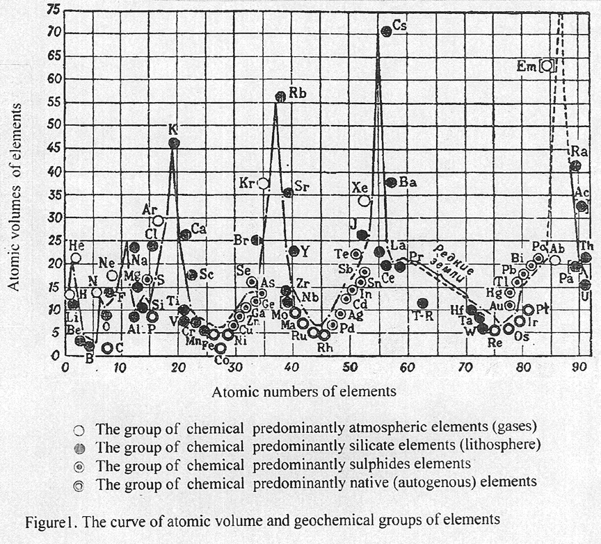 Reprinted with permission from Publishing House “Encyclopedia”, T.10. Gold is most frequently found in the free state. Gold is often alloyed with silver. Similarly gold can be alloyed with copper and more rarely with bismuth, antimony, platinum, palladium, rhenium or iridium. Gold also occurs combined with tellurium or selenium. Main auriferous minerals are represented by electrum Au-Ag,  2. CLASSIFICATION OF GOLD DEPOSITS There are a lot classifications of natural deposits of gold. One of the first has suggested by V.G.Emmons (1937), that based on various depths and temperatures of precipitation of ore minerals. So, he differentiated among them a hypothermal, mesothermal and epithermal deposits of gold. Moreover, he noted skarn and pegmatite sources of gold. Among hydrothermal deposits of gold he allocated hypothermal gold - quartz, mesothermal gold - sulphidic and epithermal gold - silver ore formations. N.V.Petrovskaya (1955) defined the follow three groups of hydrothermal auriferous ores: quartz - lowsulphidic, moderate - sulphidic and essential – sulphidic (kolchedanic) ores, connecting them to large massives of granite, small post-batholith intrusions and dykes of granodiorite and, at last, with keratophyre. The classification of auriferous deposits, offered by J.J.Bache (1980), has based on three aspects: on geostructural context, the nature of the environment rocks and on mineralogical ore associations. The gold deposits are subdivided into a three large groups: pre-orogenic submarine volcano-sedimentary deposits; post-orogenic subterranean plutono-volcanic deposits; and detrital deposits (placers). The first two groups of deposits have a fundamental difference in the mode of formation an auriferous ores. In the submarine pre-orogenic volcano-sedimentary group, the main cause of deposition the ore minerals is a sharp fall of temperature, when the hot hydrothermal solutions arrive into the cold sea water. In the terranean post-orogenic plutono-volcanic group the main parameter, whose variation induces deposition gold minerals is the suddenly fall of pressure: an explosive phenomenon that decompress the solution causing them to boil. Among the detrital deposits there are old ancient and young gold placers of eluvial, alluvial, deltaic or coastal beach genesis. In our opinion, the main reason of formation the auriferous epochs and deposits are caused by relay of geochemical and geodynamic mode at the development of the Earth, when on the change of waterless granulite metamorphism of early Archean has came waterfull amphibolite metamorphism and granite magmatism, that located in late Archean granite-green belts or in Phanerozoic geosynclinals and island volcanic arcs at the geodynamic conditions of pulsating-expanding Earth. The generation of large and super large deposits rich of gold is connected with processes of tectono-magmatic activity, rejuvenation, secondary concentration and introducing auric metals by the gas-fluid hydrothermal solution from a new deep underlying intrusions of granites and others magmatic rocks. In that reason we suggest a new “Geodynamic classification of gold deposits of the Earth”, based on the uniform hypothesis of the primordial hydridic Earth, designed by V.N.Larin (1980), in which the geodynamic and tectonic conditions of origin deposits of gold have been considered, as well as their genetic connection with magmatic, sedimentary and metamorphic formations; emphasizing mineralogical types of gold ores (Table 2). Table 2 Geodynamic classification of gold deposits of the Earth 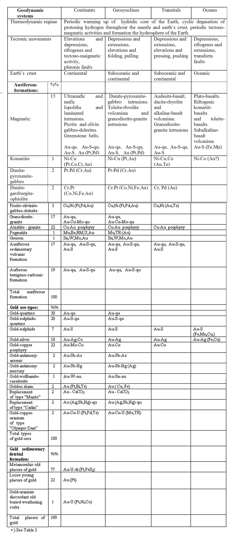
3. AURIFEROUS EPOCHS OF THE EARTH Scientific and practical interest represents the distribution amounts of gold in initial deposits and placers on a geological times of their formation. The calculations have shown, that out of the total reserves and resources of gold in the revealed deposits in amounts of 195,000 t the richest epochs appeared to be: late Archean (3.0 – 2.5 Gа) = 94,500 t (48.4%) and Phanerozoic (440-0 Ма) = 90,000 t (46.2%). In the Proterozoic epoch (2.5-0.5 Gа) it is revealed only 10,500 t (5.4 %) resources of gold (Table 3, Figure 2). It seems remarkable, that the total amounts of gold and the duration of formation rich deposits both in late Archean and in Phanerozoic are approximately equal and the intervals of times make nearly 450-500 Ма. The maximum formation of the richest gold deposits fall on follow period of time: 2.7-2.6 Gа, 320-280 Ma, 130-80 Ma and 20-0 Ма ( Konstantinov et.al., 2000; Krutoyarskiy et. al., 2000 ). The synthesis of petrochemical data on all diapason of geological time has demonstrated a sharp increase of concentration potassium in metamorphic, sedimentary and magmatic rocks in late Archean and early Proterozoic (Figure 2) (Crustal..,1974). The process of enrichment potassium in Earth's crust was universal, suddenly and global as a geochemical phenomenon. It has received in the geological literature the name " of potassium explosion ". The petrological consequence “of potassium explosion” was an extremely wide development of granites and formation a granite layer in the Earth's crust. The cause of this appearance it is necessary to search in evolution of composition of the mantle. The potassium is the strongest chemical base and carreing out of it is) connected with the change of an acid-basic mode of interaction in the bowels of the Earth. About it testifies the change of composition of fluids in the geological time. The granulite metamorphism of early Archean proceeded under influence of a waterless, sharply restored fluid, in which composition Н2 and СН4 prevailed. For late Archean and Proterozoic formations more typically was metamorphism of amphibolite facies, which mineral balance demand high pressures of Н2О and СО2, otherwise completely oxidized fluid. Thus, the occurrence of water in structure of a deep fluid and potassium explosion are synchronous and, probably, are mutually caused. That was the cause of wide display of acid granites and genetically connected to them deposits of gold, uranium and others lithophile elements. The most ancient granites have age near 3,7-3,5 Gа, however, it were mainly sodium granites – enderbites, whose volume was rather small. Deposits of gold in connection with enderbites are not fixed, that it is possible to explain by domination of waterless granulite at that time. 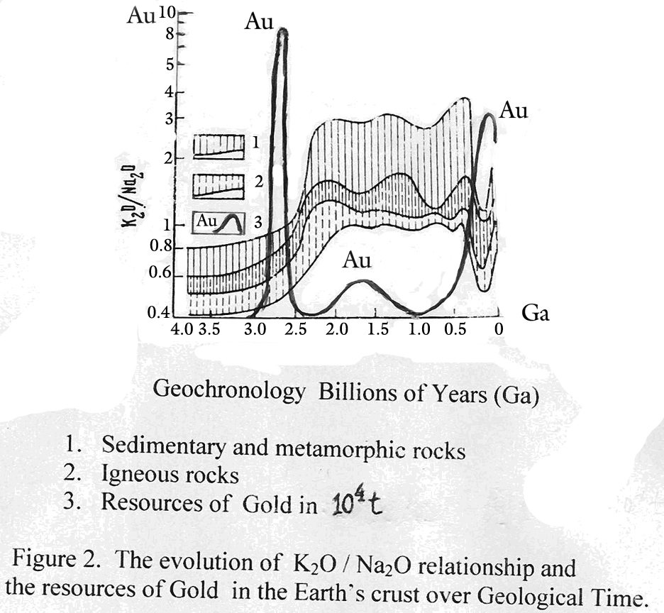 Reprinted with permission from Publishing House Nedra. Addition of the resources of gold is made by M.A. Krutoyarskiy ( 2004 ). The change of geodynamic regime at development of the Earth in late Archean was most likely caused by the beginning of its expansion. We explain the process of oceanic formation by the general expansion of the Earth and, consequently, on the area of the distribution oceanic crust. Relative distributions of the areas of continental and oceanic crust show, that in order to account for the oceanic formation it is possible to assume the increaseing of the Earth’s surface approximately in 2.5 times (Larin, 1980). The geosynclinal structures began to start on continents in Archean-Proterozoic time. The volcano-sediment formations were deposited on the oceanic type crust in the troughs, as the result of this process the green-stone belts were formed. Table 3 Auriferous formations and (their) resources of gold on the Earth 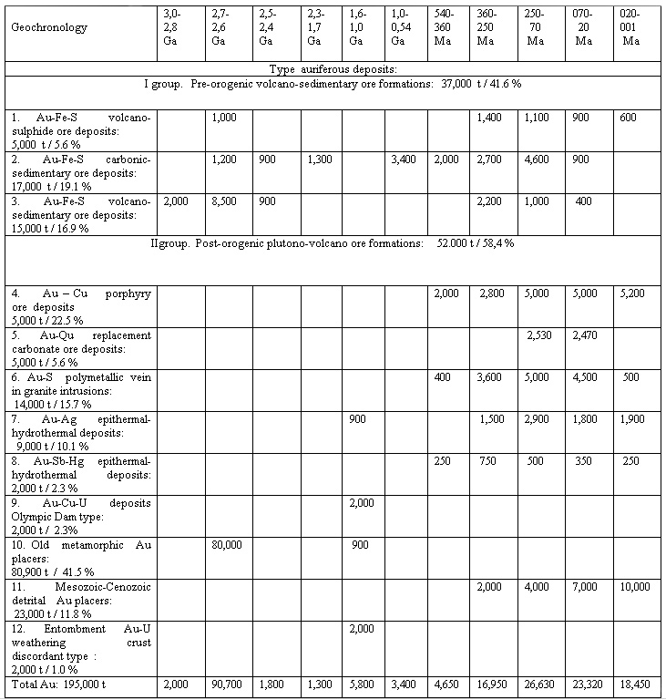
The formation of the ocean is a relatively young phenomenon. It is reliably dated to start in the late Paleozoic and continued with maximal activity in Mesozoic and Cenozoic aras. Most probably, the Pacific ocean is an exception, because its peripheral structural features do not preclude initial growth in early Precambrian time (Khain, 1971; Pushcharovsky,1972). The Earth’s expansion, as estimated by the rate of the growth of the oceans, evidently, accelerated in current of time. The total area of the “young” oceans ( the Atlantic, Indian, and Arctic), approximately equals to the “old” Pacific ocean. The area of the bottom of all oceans has particularly increased sharply at Mesozoic – Cenozoic eras, that is complied with the increasing volume of water in oceans and indirectly with formation of a rich deposits of gold, uranium and rare lithophile metals in the geosynclines and areas of tectono-magmatic activization. The lamination of external geosphere of the Earth on the crust, pirolite and gipolite with rather contrast distribution of potassium, rubidium and, accordingly, radiogenic strontium postulated in the past time the contrast between the geochemical character of allocation of these elements in the zone of sedimentation, depending on the process of the ocean formation, which subsequently resulted in disclosure of more and more deeper horizons of the planet. The carbonates of calcium fix the isotope composition of strontium in the water, from which they fall out, that allows to consider the evolution of the ratio 87 Sr / 86Sr in the ocean’s water of the Earth. The curve, describing the evolution of isotope composition of strontium in the oceans at that time appeared rather peculiar (Figyre 3),(Faure and Powell, 1972). Three cardinal perturbations are clearly prominent on it, which, obviously, reflects essential changes of the image of the Earth. The data show exponential increase of the relation 87Sr/ 86Sr in waters, circumfluent of the planet during the period from 3,0 up to 1,1 Ga. The extrapolation of this curve until now has resulted to the modern value of the isotopic relation of strontium in the continental crust. However, in late Precambrian, approximately on the boundary of middle and upper Riphean, this relation sharply deviates from the exponential dependence (perturbation А) that testifies to the appearance of a source with the low isotope attitude of strontium exposed on the extensive territory. According to V.N.Larin (1980), it is, most probably, connected with the beginning of active the ocean formation, during which low potassium emanated the tholeiite basalts in huge amounts, that accompanied the formation of the oceanic depressions. It is possible to connect the sharp failure of the curve (perturbation В), coming on the end of Paleozoic and beginning of Mesozoic, with the acceleration of the processes of ocean formation in Mesozoic era, when there was disclosure the Atlantic and Indian young oceanic depressions alongside with proceeding expansion of the existent Pacific ocean. The acceleration of the ocean formation, connected with the expansion of the Earth, by all means should cause the strain, and at the end the break of the mantle layer restite in the middle part of the ocean couch. It accompanied by the rise and output on the surface the again formed silicate mattress of the layer B, arising by the way of metasomatism of the intermetalic layer C of the upper mantle. The content of Rb in intermetalic connections of the layer C should indicate initial concentration of this element on the planet and, hence, should not be less, than in gipolite. In this connection, the sharp increase of the relation 87Sr / 86Sr in oceanic carbonate sediments (perturbation С) is explained (Figure 3). At the pressure of level 10 GPа and above, the formed silicate mattress should be represented by spinel-garnet mineral association, whereas at reduction of pressure will prevail ever more pyroxene-olivine paragenesis. As far as the isomorphic capacity of lattices olivine and pyroxene is much lower, than at garnet and spinel (in the attitude of potassium, uranium and others lithophile elements), the change of mineral paragenesis, formed by metasomatic way in the bowels of middle oceanic ridges, (necessarily) should necessarily be accompanied by an increasing the gab of these elements. Exactly here it possible that a huge source which was caused by late Jurassic the perturbation C in geochemistry of potassium and strontium in the zone of sedimentation at the bottom of oceans of the Earth (Larin, 1980). 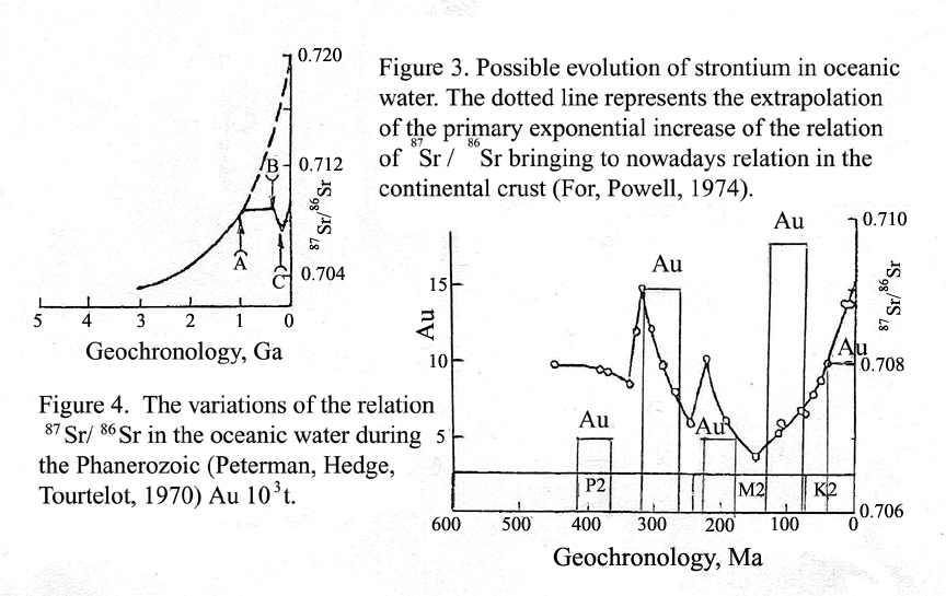 Reprinted with permission from Publishing House Nedra. Taken from Larin (1980). Modified by Krutoyarskiy ( 2004 ). The deep-water red clays of pelagian parts of the oceans along with the high contents of ore elements have a sharply increased concentration of potassium and uranium. In the light of what has been stated above, it should be connected, as far as the ore matter, to axial parts of oceans, with process of silication intermetalic joints of the upper mantle. Admit the community of sources for these elements and ore matter, and also the same cause of conditionality of characteristic "failures" on the curve evolution of potassion and radiogenic strontium in Mesozoic-Cenozoic, it is possible to involve the data of isotopic strontium for defining the time of the beginning of entrance ore matter through the axial zone of oceanic couch. According to the curve, reflecting variation of the relation strontium at ocean’s carbonates during the Phanerozoic, the first portions of ore matter could begin to enter from the end of late Jurassis time (150-140 Ma), but from the beginning of Cenozoic the process of endure of ore matter has become more intensive. At that same time on the continents and transitive zones to the oceans took place the processes of tectono-magmatic activity which generated a lot of gold deposits (Table 2, Figure 4). The formation of large and superlarge deposits of gold with reserves more than 500-1000 t is connected with the periods of tectono-magmatic activity, at the processes of reuvination and secondary concentration of gold by fluid and hydrothermal solutions, rising from more young intrusions of granites and other magmatic masses, lieing on significant depths from 1-5 up to 10 km (Boyle, 1955; Bache, 1987; Rundquist, 1993; Konstantin et.al, 2000; Safonov, 2003; Potters et al., 2004). REFERENCES Bache J.-J. (1987). - World gold deposits, a geological classification. - Elsevier Science Publishing Co., NY, p. 178. Boyle R.W. (1955). - The geochemistry and origin of the gold bearing quartz veins and lenses of the Yellowknife Greenstone belt. - Econ. Geol., N 50, pp.51-66. Betekhtin A.G. (1950). - Mineralogy. – State Publishing House, M., p.956. Emmons W.H. (1937). - Gold Deposits of the World. - NY. Engel A.E.J., Itson S.P. et. al. (1974). - Crustal evolution and global tectonics: a petrogenic view. - Geol. Soc. of America Bull., v.85, N 6, pp. 843-858. Gold. (2000). - Mineral Summary. - NDMP, Brazil, v.20, p.54. Gold. (2004) - Minerals Yearbook, Metals and Minerals. USGS. Washington,.pp. 32.1-32.13. Goldsmidt V.M. (1937). – Crystalochemistry. –Khimtheorizdat, M . Goncharov V.I., Vashilov Yu.Ya., Sidorov A.A.,, Volkov A.V., Gorjachev N.A. (2004) - The Deep structure of large precious metal deposits of northeast Asia. - ИГЕМ the Russian Academy of Science, M., pp.69-94. Hutchinson R.W. (1975). - Lode gold deposits; the case for volcanogenic derivation. - Portland, Oregon, Dep. Geol. Miner. Ind. Bull., , pp.64-105. Konstantinov M.M., Nekrasov E.M., Sidorov A.A. et.al. (200). The auriferous giants deposits of Russia and World. - Scientific world. M, p. 270. Krutoyarskiy M.A., Larin V.N.Larin, Magakian I.G., Smyslov A.A. (2000) – The Brief Explanatory Note to “ Metallogenic Map of the Geodynamic Systems of the Pulsatory – Expanding Earth,” scale 1:15,000,000. - IANSS, S-Pt.,Chicago, p.76. Larin V.V. (1980). – The hypothes of primary hydridic the Earth. – Nedra, M., p.215. Petrovskaya N.V. (1955). - . To the question on principles of mineralogical classification of types initial auric ores. – Trudy NIGRI, gold, vyp..20. Pushcharovskiy Yu.M. (1972). - Introduction at tectonic of the Pacific segment of the Earth. - Nauka, М.,, p. 222. Ridler R.H. (1976). - Relationship of mineralization to volcanic stratigraphy in the Kirkland lake - Larder lake area, Ontario.-Geol. Assoc. Can. Proc., N 21, pp.33-42. Rudnik V.A., Sobotovich E.V. (1984). - The Early history of the Earth. - М., Nedra, p.349. Rundquist D.V. (1993). – The epochs of reuvenation Precambrian crust and their metallogenic meaning. - Geology of ore deposits. N 6, pp. 467-480. Safonov Yu.G. (2003). – The auriferous deposits of the World - genesis and metallogenic potential. - Geology of ore deposits, т.45, N 4, pp. 305-320. For G., Pauell J. (1974) - Isotopes of strontium in geology. – Izdan. Mir, M. p.214. Shumilin M.V. (1996) - Balance of world production and resources of Uranium. – Rasvedka i okhrana nedra., N3, pp.10-11. About the Editor and Author. Mikhail A. Krutoyarskiy. Mikhail A. Krutoyarskiy graduated from the Leningrad State University (USSR) in 1953 as an exploration geologist. Since 1954 to 1971 his industrial and scientific activity was connected with the Leningrad Scientific Research Institute of Arctic Geology. Krutoyarskiy has worked in geological mapping and searching of diamondiferous kimberlites and placers on the Siberian Platform. In 1956 he participated in the discovery of a the Olenek region and exploration of the first in Russia diamondiferous kimberlite pipe “Leningrad”. Between 1959 and 1968, he has worked as a research geologist for exploration of the Yakut province, studying kimberlite rocks, mineralogy and physical properties of natural diamonds. In 1961 Krutoyarskiy has created the “Forecast map for searching of a new diamondiferous deposits on the North Siberian platform” (scale 1:500,000). From 1969 to 1971 he mapped an ancient complex of metamorphic terrain on Anabar shield. As a result of these explorations he had written a lot of scientific reports, articles and two books. In 1968 he successfully defended his Ph.D. thesis on the diamondiferous of the Western Yakut kimberlite province. Since 1972 until 1992 Krutoyarskiy worked for the Scientific Research Institute Okeangeologia as a senior scientific geologist, where he has led a new scientific direction - the estimation of prospects the Arctic shelf for the diamonds and gold placers. To resolve this problem he had made in 1972 the “Forecast map of auriferous North-Taimyr province” (scale 1:1,000,000), where he segregated 9 perspective areas for searching gold deposits and placers. Among them has been Cheliuskin peninsula, on which the Polar expedition has found two gold placers in 1981. As a result of these works the forecast was confirmed and the last “Gold Klondike” of the XX century in Arctic was detected. In 1996 Krutoyarskiy has written the doctoral thesis of the “Metallogeny of Geodynamic Systems of the Pulsating-Expanding Earth”, to which he has compiled the “Metallogenic Map of the Earth”. The doctoral thesis and the map have been completed after his emigration to USA at the end of 1996. Now he is working as a consultant geologist in U.S. Geological Survey and at the International Academy of Natural and Social Sciences. The vast scientific interests of Krutoyarskiy have found reflection in the numerous published works, devoted to various questions of the geology, petrology and mineralogy of kimberlites, diamonds and gold; to the forecast metallogenic diamondiferous and auriferous maps. He has authored or coauthored of 5 books and more than 100 professional reports, articles, geological and metallogical maps. The completion of the collective work " Metallogenic Map of the Geodynamic Systems of the Pulsating-Expanding Earth”(scale 1:15.000.000) and the “Explanatory Note” to it has allowed M.Krutoyarskiy (as responsible editor) to take part in the International Geological Congresses in Brazil (2000), Italy (2004) and Norway (2008). Presentation of this Metallogenic map and Explanatory note has caused the great interest of geologists of the world. The Russian Academician N.A.Shilo had written in his review, that this work “will be splendour of modern geology” and allows on a scientific basis to discover the deposits of useful minerals, where … “Sezam opened the vaults to his treasures”. |